
Awantipora: Difference between revisions
No edit summary Tags: Visual edit Mobile edit Mobile web edit |
m Added weather link |
||
| Line 177: | Line 177: | ||
==External links== |
==External links== |
||
* [http://www.bongblogger.com/kashmir-diary-ruins-of-ancient-temples-of-awantipora-srinagar/ Ruins of Ancient Temples of Awantipora] |
* [http://www.bongblogger.com/kashmir-diary-ruins-of-ancient-temples-of-awantipora-srinagar/ Ruins of Ancient Temples of Awantipora] |
||
* [https://www.weather-ind.com/en/india/awantipora Awantipora Weather] |
|||
==References== |
==References== |
||
Revision as of 16:00, 7 September 2020
Awantipora
Avantipur Awantipur, Aavantipur | |
|---|---|
Town | |
 Remains of Avantisvamin Temple | |
 Awantipora Location in Jammu and Kashmir, India  Awantipora Awantipora (India) | |
| Coordinates: 33°55′24″N 75°00′46″E / 33.9232602°N 75.012846°E | |
| Country | |
| Union territory | Jammu and Kashmir |
| District | Pulwama |
| Elevation | 1,582 m (5,190 ft) |
| Population (2011) | |
| • Total | 6,250 |
| Time zone | UTC+5:30 (IST) |
| Vehicle registration | JK13 |
| Sex ratio | ♂/♀ |
| Website | pulwama |
Awantipora, also known as Avantipur[1] or Aavantipur[2], is a town on the banks of the River Jehlum in the Pulwama district of the Indian union territory of Jammu and Kashmir. It is on the Jammu-Srinagar National Highway (now called the NH 44), south of Srinagar and north of Anantnag. Awantipora was named after the Kashmiri king Avantivarman and has the ruins of two 9th century Hindu temples built by him.
Awantipora tehsil is a subdistrict of Pulwama district.[3]
History
It is said that the town was founded by Avantivarman who was the first king of the Utpala dynasty, and ruled Kashmir from 855 to 883 AD.[4] Avantivarman built a Hindu temple in Awantipora dedicated to Vishnu called "Avantisvamin" before he became king, and during his reign he built a second Hindu temple in Awantipora called "Avantisvara" dedicated to Shiva. Both temples were built in spacious rectangular paved courtyards. They were destroyed in the middle ages. They were excavated by the archeologist Daya Ram Sahni in the early 20th century.[4] The Avantisvamin temple is located at 33°55′24″N 75°00′46″E / 33.9232602°N 75.012846°E and Avantisvara is at 33°55′41″N 75°00′16″E / 33.9279606°N 75.0045311°E. They are protected and maintained by the Archaeological Survey of India.
-
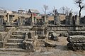 The Avantisvamin temple
 -
 The Avantisvara temple


Demographics
As of 2011[update] India census,[5] Awantipora had a population of 6,250. Males constitute 54% of the population and females 46%. As per 2011 census, awantipora has an average literacy rate of 84.38%, higher than the national average of 74%. Male literacy was 91.84%, and female literacy was 82.55% 9% of the population is under 6 years of age. As per 2011 census of India, Awantipora has 4% Hindu 6% Sikh and 90% Muslim population.
[Gulzarpora 1]Villages in Awantipora tehsil
The villages along with their patwar halqa (revenue circle) in Awantipora tehsil are listed below. There is a branch of Axis Bank in the village of Larkipora.[6]
| Village[7] | Patwar Halqa |
|---|---|
| Awantipora (town) | Awantipora |
| Kanjinag | Awantipora |
| Rajpora Uller | Awantipora |
| Jawbrari | Barsoo |
| Barsoo | Barsoo |
| Padgampora | Padgampora |
| Aghanjipora | Padgampora |
| Larkipora | Padgampora |
| Goripora | Padgampora |
| Kanlibagh | Padgampora |
| Udiipora | Padgampora |
| Dangerpora | Padgampora |
| Malanghpora | Malanghpora |
| Rakhwatalpora | Malanghpora |
| Kariwa Rambirabad | Malanghpora |
| Awanpora | Malanghpora |
| Tokna | Tokna |
| Gulzarpora | Tokna |
| Beighpora | Tokna |
| Shalltokna | Tokna |
| Reshipora | Reshipora |
| Nowgamuller | Reshipora |
| Khandaypora | Reshipora |
| Renzipora | Reshipora |
| Chakhar | Reshipora |
| Kanipora Uller | Reshipora |
| Dogripora | Dogripora |
| Kawni | Dogripora |
| Noorapora | Noorapora |
| Chersoo | Chersoo |
| Sail | Chersoo |
| K.Koot | K.Koot |
| Mirzapora | K.Koot |
| Larmoh Awanpora | K.Koot |
| Poshwan | K.Koot |
| Hariparigam | Hariparigam |
| Pratabpora | Hariparigam |
| Midoora | Midoora |
| Khankah | Midoora |
| Gorikadal | Midoora |
| Shabadballa | Midoora |
| Shabadpayeen | Midoora |
| Panzgam | Panzgam |
Air Force Station
Awantipur Air Force Station is situated near Awantipora at Malangpora about 5 km from Pulwama town.
See also
External links
References
- ^ Corlett, Dudley S. (1923), "The Gardens of Kashmir", Art and Archeology, The Archeological Society of Washington, affiliated with the Archeological Institute of America, p. 27
- ^ "Annual Report 1976-77", Ministry of Education and Social Welfare, Government of India, p. 223
- ^ "About District/ Administrative Setup/ Tehsil", Pulwama District, Government of Jammu and Kashmir, retrieved 22 July 2020
- ^ a b "Avantiswami Temple, Avantipur". Archeological Survey of India. Retrieved 23 July 2016.
This web-page spells the town Avantipur, and says that it is in Anantnag district, which it was before the creation of Pulwama district in 1979. - ^ "Census of India 2001: Data from the 2001 Census, including cities, villages and towns (Provisional)". Census Commission of India. Archived from the original on 16 June 2004. Retrieved 1 November 2008.
- ^ "Directory/Public Utilities/Banks", Pulwama District, Government of Jammu and Kashmir, retrieved 23 July 2020
- ^ "Property Rates 2018-2019 (Notification No: 02/DCP-SQ of 2018)" (PDF), Pulwama District, Government of Jammu and Kashmir, p. Tehsil Awantipora Form III (C9 to C12) (2018-19), 31 March 2018, retrieved 23 July 2020
Template:Indian Air Force bases
Cite error: There are <ref group=Gulzarpora> tags on this page, but the references will not show without a {{reflist|group=Gulzarpora}} template (see the help page).