
Munnar: Difference between revisions
Ruben Joseph (talk | contribs) |
|||
| Line 147: | Line 147: | ||
* [http://www.irisholidays.com/kerala/munnar-tourist-places.html Tourist Attractions in Munnar] |
* [http://www.irisholidays.com/kerala/munnar-tourist-places.html Tourist Attractions in Munnar] |
||
* [http://www.pbase.com/oochappan/munnar Munnar photo impressions] |
* [http://www.pbase.com/oochappan/munnar Munnar photo impressions] |
||
* [http://indigenoustour.com/destination/kerala--kerala-tourism-/munnar- Munnar Tourism] |
|||
* {{wikitravel}} |
* {{wikitravel}} |
||
Revision as of 06:56, 27 May 2011
This article needs additional citations for verification. (July 2010) |
Munnar
Munnar മൂന്നാര് | |
|---|---|
town | |
| Population | |
| • Metro | 68,205 |
| Website | idukki.nic.in tourism |
Munnar (Malayalam: മൂന്നാര്) is one of the most popular hill-resort towns in Kerala and in southern India. Munnar is located on the Western Ghats, situated in the Idukki district. The name Munnar is believed to be derived from the Malayalam/Tamil words Munu (three) and aaru (river), referring to the town's strategic location at the confluence of the Muthirappuzha, Nallathanni and Kundaly rivers.
The Munnar panchayat in the Devikulam block is the largest panchayat in the Idukki district having an area measuring nearly 557 km².
The nearest major railway stations are at Ernakulam and Aluva (approximately 110 km by road). The nearest airport is Cochin International Airport, which is 105 km away.

Geography and climate
The region in and around Munnar varies in height from Template:M to ft to Template:M to ft above mean sea level. Munnar enjoys a salubrious climate. The temperature ranges between Template:C to F and Template:C to F in winter and Template:C to F and Template:C to F in summer. The tourist season in Munnar is from August to May. However, even the monsoons are lovely with many streams and rivulets in the area and post drizzle the dew drenched tea gardens looking majestic and heavenly enshrouded in light mist . See:map
A drive from Udumalpet to Munnar gives one unforgettable views of the Western Ghats. Chinnar is 25 km from Udumalpet and is home to the Indra Gandhi wildlife sanctuary which is famous for known for the elephants that inhabit the area. Chinnar is also the border between Tamil Nadu and Kerala. As you cross the Tamil Nadu border and enter Kerala, you can see a distinct change in the vegetation. While the Tamil Nadu areas have vegetation dominated by shrubs and thorny trees, the vegetation in Kerala is lush green with tall trees. Marayur is 20 km from Chinnar, famous for its sandalwood forests which often fall prey to poachers.
As you drive past Marayur towards Munnar, you can see Anamudi, the highest mountain peak in south part of India to your right. This area also houses the Eravikulam National Park famous for its population of the Nilgiri Tahr, a mountain goat. This area offers abundant scope for mountain trekking. On the trekking route to the Anamudi peak, you can see a Trout farm. The rest of the drive towards Munnar is through neatly manicured tea estates owned by Tata Tea Ltd and Waterfall Estate. The landscape is also dotted by tea factories and labour lines.
Economy
Most residents of Munnar are employed in the tea industry, or are involved in the tourism business. In 2000, the Government of Kerala declared Munnar as a tourist spot. This has helped in attracting more tourists to this beautiful hill resort. Several protected wildlife areas and the regions attractive climate area attract many tourists who support the many hotels, restaurants and transport businesses in Munnar and constitute an important, if seasonal, mainstay for its economy. Besides hotels, Munnar also has fantastic options for alternative non-hotel stays like homestays, guest houses and independent villas.
Tourism


Eravikulam National Park
Located about 15 km from Munnar, this park is famous for its endangered inhabitant - the Nilgiri Tahr. Spread over an area of 97 km2., this park is also home to several species of rare butterflies, animals and birds. A great place for trekking, the park offers a magnificent view of the tea plantations and also the rolling hills caressed by blankets of mists. The park becomes a hot destination when the hill slopes here get covered in a carpet of blue, resulting from the flowering of Neelakurinji. It is a plant endemic to this part of the Western Ghats which blooms once in twelve years. The last time it bloomed was in 2006.
Anamudi Peak
Situated about 13 kilometres (8.1 mi) from Munnar town, Anamudi (2,695 metres (8,842 ft)) is Kerala's highest mountain and the highest Indian mountain south of the Himalayan range. Treks to the peak are allowed with permission from Forest and Wildlife authorities at Eravikulam.
Mattupetty
Another place of interest, located about 13 km from Munnar Town, is Mattupetty. Lying at a height of 1700 m above sea level, Mattupetty is known for its storage masonry dam and the lake, which offers boat rides, enabling one to enjoy the surrounding hills and landscape. Mattupetty's fame is also attributed to the dairy farm run by the Indo-Swiss Livestock Project, where one would come across different high yielding breeds of cows. Mattupetty with its lush green tea plantations, rolling grasslands and the Shola forests is also ideal for trekking and is home to a variety of birds.

Pallivasal
Pallivasal, located at about 3 km from Chithirapuram in Munnar is the venue of the first hydro-electric project in Kerala. It is a place of immense scenic beauty and is often favoured by visitors as a picnic spot.
Chinnakanal
Near the town of Munnar is Chinnakanal and the waterfalls here, popularly known as Power House Waterfalls, cascade down a steep rock 2000 m above sea level. The spot is enriched with the scenic view of the Western Ghat ranges.
Anayirangal
When you have traveled about seven kilometers from Chinnakanal, you reach Anayirangal. Anayirangal, 22 km from Munnar, is a lush green carpet of tea plants. A trip on the splendid reservoir is an unforgettable experience. The Anayirangal dam is surrounded by tea plantations and evergreen forests.
Top Station

Top Station, which is about 27 km from Munnar is at a height of 1700 m above sea level. It is the highest point on the Munnar-Kodaikanal road. Travellers to Munnar make it a point to visit Top Station to enjoy the panoramic view it offers of the neighboring state of Tamil Nadu. It is one of the spots in Munnar to enjoy the Neelakurunji flowers blooming over a vast area.
Tea Museum
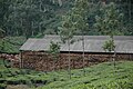
Munnar has a legacy of its own when to comes to the origins and evolution of tea plantations. Taking account of this legacy and to preserve and showcase some of the exquisite and interesting aspects on the genesis and growth of tea plantations in Kerala's high ranges, a museum exclusively for tea was opened some years ago by Tata Tea in Munnar. This Tea Museum houses curios, photographs and machineries; all of which have a story to tell on the origins and growth of tea plantation in Munnar. The museum is located at the Nallathanni Estate of Tata Tea in Munnar and is worth a visit.
Flora and fauna
Most of the native flora and fauna of Munnar have disappeared due to severe habitat fragmentation resultant from the creation of the plantations. However, some species continue to survive and thrive in several protected areas nearby, including the new Kurinjimala Sanctuary to the east, the Chinnar Wildlife Sanctuary, Manjampatti Valley and the Amaravati reserve forest of Indira Gandhi Wildlife Sanctuary to the north east, the Eravikulam National Park and Anamudi Shola National Park to the north, the Pampadum Shola National Park to the south and the proposed Palani Hills National Park to the east. These protected areas are especially known for several threatened and endemic species including Nilgiri Thar, the Grizzled Giant Squirrel, the Nilgiri Wood-pigeon, Elephant, the Gaur, the Sambar, and the Neelakurinji (that flowers once in twelve years). [2][3]
Gallery
-
-
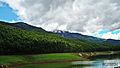
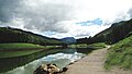
Mattupetty dam
-
 Mattupetty dam
 -
-
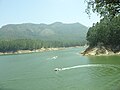 Boating in Mattupetty Dam reservoir
 -
 On the way to Mattupetty Dam
 -
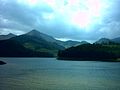
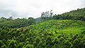
 Scenary in Munnar
 -
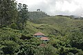
 Munnar tea plantations
 -
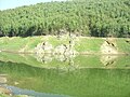
 Manager's bungalow in Kundaly, Munnar
 -
 Munnar Dam
 -

-
Mattupetty dam at Munnar -

-
-

-
-
-
 Nilgiri Thar
 -
 Eucalyptus trees were introduced by the British
 -
 Way to Munnar
 -
 View from Echo poin
 -
 View from Echo point in Munna
 -
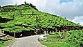
 Tea Gardens
 -
 Tea Gardens in Munnar
 -
 Tea Gardens in Munnar Town
 -
 Tea Garden
 -
 Podhanmedu View point
 -
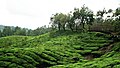
 Munnar Tea Gardens
 -
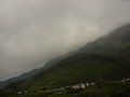
 Munnar covered in Mist
 -
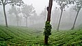 Mist covered Tea Gardens in Munnar
 -
 Mist Covered Eucalyptus trees
 -
 Echo Point in Munnar
 -
 Echo point


.jpg)
References
- ^ Public Relations Department, Govt. of Kerala., Statistical Data, retrieved 6/21/2007 Idukki
- ^ Government of Kerala, Forest and Wildlife Department, Notification No. 36/2006 F&WLD (6 October 2006) retrieved 5/12/2007 Kerala Gazette
- ^ Mathew Roy (Sep 25, 2006) "Proposal for Kurinjimala sanctuary awaits Cabinet nod" the Hindu, retrieved 5/12/2007 the Hindu
raja
