
Geography of Taiwan Island: Difference between revisions
undo content fork of Geography of Taiwan |
OjdvQ9fNJWl (talk | contribs) Undid revision 490882479 by Kanguole (talk) Not intended to be a content fork. Article should be similar to North Island or South Island |
||
| Line 1: | Line 1: | ||
{{Infobox islands |
|||
#REDIRECT [[Geography of Taiwan]] |
|||
| name = Taiwan Island |
|||
| image name = Taiwan NASA Terra MODIS 23791.jpg |
|||
| image caption = Satellite image of Taiwan Island |
|||
| image size = |
|||
| locator map = {{Location map|Asia|caption=|float=center|width=220|lat=24.05|long=120.15}} |
|||
| map caption = Taiwan Island (East Asia) |
|||
| native name = 臺灣 or 台灣 |
|||
| native name link = Chinese language |
|||
| nickname = Formosa |
|||
| location = [[East Asia]] |
|||
| coordinates = {{coord|23|46|N|121|0|E|display=inline,title}} |
|||
| archipelago = [[Taiwan]] |
|||
| total islands = |
|||
| major islands = |
|||
| area_km2 = 35801 |
|||
| length km = 394 |
|||
| width km = 144 |
|||
| highest mount = [[Yu Shan]] |
|||
| elevation m = 3952 |
|||
| country = [[Taiwan]] |
|||
| country admin divisions title = |
|||
| country admin divisions = |
|||
| country admin divisions title 1 = |
|||
| country admin divisions 1 = |
|||
| country admin divisions title 2 = |
|||
| country admin divisions 2 = |
|||
| country capital = [[Taipei]] |
|||
| country largest city = [[Taipei]] |
|||
| country largest city population = 2,630,191 |
|||
| population = 23,000,000 |
|||
| population as of = 2005 |
|||
| density km2 = 642.44 |
|||
| ethnic groups = '''[[Taiwanese people]]'''<br>98% [[Han Chinese]]<br>''70% [[Hoklo people|Hoklo]]''<br>''14% [[Hakka people|Hakka]]''<br>''14% [[Mainlander]]''<br>2% [[Taiwanese aborigines|Aboriginal Taiwanese]] |
|||
| additional info = |
|||
}} |
|||
{{Infobox Chinese |
|||
|pic=Taiwan_Chinese.png |
|||
|picsize=150px |
|||
|t=[[wikt:臺灣|臺灣]] or [[wikt:台灣|台灣]] |
|||
|s=[[wikt:台湾|台湾]] |
|||
|j=Toi<sup>4</sup> Waan<sup>1</sup> |
|||
|p=Táiwān |
|||
|w=T'ai²-wan¹ |
|||
|bpmf=ㄊㄞˊ ㄨㄢ |
|||
|poj=Tâi-oân |
|||
|h=Thòi-vàn |
|||
|buc=Dài-uăng |
|||
|gr=Tairuan |
|||
|wuu={{IPA-wuu|d̥e uɛ}} |
|||
|altname={{lang-pt|(Ilha) Formosa}} |
|||
|t2={{linktext|福爾摩沙}} |
|||
|s2=福尔摩沙 |
|||
|p2=fúěrmóshā |
|||
|bpmf2=ㄈㄨˊ ㄦˇ ㄇㄛˊ ㄕㄚ |
|||
|j2=fuk<sup>1</sup>ji<sup>5</sup>mo<sup>1</sup>saa<sup>1</sup> |
|||
|l2=beautiful island |
|||
}} |
|||
'''Taiwan''' (historically called "'''Formosa'''" especially prior to 1945, from [[Portuguese language|Portuguese]]: ''Ilha Formosa'', "Beautiful Island") is a medium-sized [[island]] part of the Taiwan [[archipelago]] in [[East Asia]], located at 23°30" N, 121°00" E and running through the middle of the [[Tropic of Cancer]] (23°5" N). It makes up the majority of the territories of the [[Republic of China]] (ROC, commonly known as "Taiwan"), after the ROC lost its [[mainland China]] territory in the [[Chinese Civil War]]. |
|||
== Physical boundaries == |
|||
{{Main|Geography of Taiwan}} |
|||
Taiwan Island is the main island of the Taiwan archipelago and comprises about 99%<ref>The land area of Taiwan island proper (Formosa) is 35,980 km2,the total area of [[Taiwan Area|the ROC jurisdiction]] is 36,191 km2.</ref> of the [[Taiwan Area|current jurisdiction of the Republic of China]]. The island is separated from [[China]] by the [[Taiwan Strait]], which ranges from {{convert|220|km|mi|0|abbr=on}} at its widest point to {{convert|130|km|mi|0|abbr=on}} at its narrowest point.<ref>{{cite web | url = http://www.gio.gov.tw/ct.asp?xItem=32610&ctNode=2581 | title = Geography | author = Government Information Office, Republic of China (Taiwan) | accessdate=2007-05-21}}</ref> Taiwan is bounded by the [[Bashi Channel]] in the south, the [[East China Sea]] in the north, and the [[Pacific Ocean]] in the east.<ref>{{cite web | url = http://twgeog.geo.ntnu.edu.tw/english/General/general.htm | title = Geography of Taiwan: A Summary | author = [[National Taiwan Normal University]], Geography Department | accessdate = 2007-05-21}}</ref> |
|||
Taiwan's area is {{convert|35980|km2|sqmi|0|abbr=on}} of which {{convert|32260|km2|sqmi|0|abbr=on}} is land and {{convert|3720|km2|sqmi|0|abbr=on}} is territorial water claims, making it slightly smaller than the combined area of [[Maryland]] and [[Delaware]], or slightly bigger than territory of [[Belgium]]. It is {{convert|394|km|mi|0|abbr=on}} long and {{convert|144|km|mi|0|abbr=on}} wide. It has a coastline of {{convert|1566.3|km|mi|abbr=on}}. The ROC claims an [[exclusive economic zone]] of {{convert|200|nmi|1|abbr=on|lk=in}} and a territorial sea of {{convert|12|nmi|abbr=on|1}}.<ref>{{cite web | url = |
|||
http://law.moj.gov.tw/Eng/Fnews/FnewsContent.asp?msgid=1116&msgType=en | title = Law on the Exclusive Economic Zone and the Continental Shelf of the Republic of China (中華民國專屬經濟海域及大陸礁層法) | accessdate = 2007-05-21}}</ref> |
|||
== Terrain == |
|||
{{Main|Geography of Taiwan}} |
|||
The terrain in Taiwan is divided into two parts: the flat to gently rolling plains in the west, where 90% of the population lives, and the mostly rugged forest-covered mountains in the eastern two-thirds. |
|||
The eastern part of the island is dominated by five mountain ranges, each running from north-northeast to south-southwest, roughly parallel to the east coast of the island. As a group, they extend {{convert|330|km|mi}} from north to south and average about {{convert|80|km|mi}} from east to west. They include more than two hundred peaks with elevations of over {{convert|3000|m|ft|0|abbr=on}}. |
|||
[[Image:Taiwan map large.gif|thumb|right|A [[Cartographic relief depiction|relief map]] of Taiwan.]] |
|||
== Geology == |
|||
[[File:Philippine Sea Plate br.JPG|thumb|left|Taiwan lies on the western edge of the Philippine Plate]] |
|||
{{main|Geology of Taiwan}} |
|||
The island of Taiwan was formed approximately 4 to 5 million years ago at a complex [[convergent boundary]] between the [[Philippine Plate|Philippine Sea Plate]] and the [[Eurasian Plate]]. |
|||
In a boundary running the length of the island and continuing southwards in the [[Luzon Volcanic Arc]] (including [[Green Island, Taiwan|Green Island]] and [[Orchid Island]]), the Eurasian Plate is sliding under the Philippine Sea Plate. |
|||
The western part of the island, and much of the central range, consists of sedimentary deposits scraped from the descending edge of the Eurasian Plate. |
|||
In the northeast of the island, and continuing eastwards in the [[Ryukyu]] Volcanic Arc, the Philippine Sea Plate slides under the Eurasian Plate.<ref>{{cite web |title=The Geology of Taiwan |url=http://twgeog.geo.ntnu.edu.tw/english/geology/geology.htm |publisher=Department of Geology, [[National Taiwan Normal University]] }}</ref><ref>{{cite web | |
|||
url=http://www.geo.arizona.edu/~anderson/taiwan/tai_index.html |title=Geology of Taiwan |publisher=Department of Geology, University of Arizona }}</ref> |
|||
The tectonic boundary remains active, and Taiwan experiences 15,000 to 18,000 [[earthquake]]s each year, of which 800 to 1,000 are noticed by people. The most catastrophic recent earthquake was the magnitude-7.3 [[Chi-Chi earthquake]], which occurred in the center of Taiwan on September 21, 1999, killing more than 2,400 people.<ref name="yearbook">{{cite book |title=The Republic of China Yearbook 2011 |url=http://www.gio.gov.tw/taiwan-website/5-gp/yearbook/ |chapter=Chapter 1: Geography |chapterurl=http://www.gio.gov.tw/taiwan-website/5-gp/yearbook/docs/ch01.pdf |publisher=Government Information Office, Republic of China (Taiwan) }}</ref><ref>{{cite web | |
|||
url=http://www.seismo.ethz.ch/GSHAP/eastasia/ |title=GSHAP Region 8: Eastern Asia |publisher=Global Seismic Hazard Assessment Program }}</ref> |
|||
On 4 March 2010 at about 01:20 UTC, [[2010 Taiwan earthquake|a magnitude 6.4 earthquake]] hit southern Taiwan.<ref>{{cite news |
|||
| url = http://www.cnn.com/2010/WORLD/americas/03/03/taiwan.quake/index.html?hpt=T1 |
|||
| title = 6.4-magnitude quake hits southern Taiwan |
|||
| first1 = Christine | last1 = Theodorou | first2 = Andrew | last2 =Lee |
|||
| accessdate = 4 March 2010 | date = 3 March 2010| work = CNN.com |
|||
}}</ref> |
|||
== Climate == |
|||
The climate on the island is generally [[Oceanic climate|marine]] and varies widely by season in the Northern part and the mountain areas. The South, however, belongs to the tropical belt and is warm and humid all year. From May to June it's rainy season, with almost daily showers. From July to October [[typhoon]]s are most likely to strike, on average about four direct hits per year. In the northern part of Taiwan, cloudiness is persistent and extensive during the year; in the south, however, the rainy days are always in the summertime, and 90% of the annual precipitation falls during this period. The annual rainfall is usually more than {{convert|2500|mm|in|1|abbr=on}}, close to {{convert|5000|mm|in|1|abbr=on}} in some Eastern regions. |
|||
Intensive rain from typhoons often leads to disastrous mudslides. |
|||
<gallery> |
|||
Image:Taiwanmountainbrace.JPG|Bracing on the side of a mountain in [[Chiayi County]] prevents [[landslides]] caused by typhoons. |
|||
Image:June 2011 Landslide Scars in Taiwan.jpg|Natural-colour satellite image of landslide scarred mountains in central Taiwan. |
|||
Image:Siouguluan-River-Hualien-Ta.jpg|[[Shiukuluan River]] in [[Hualien County]] |
|||
</gallery> |
|||
== Flora and fauna == |
|||
{{see also|Endemic species of Taiwan|List of national parks in Taiwan}} |
|||
[[File:長鬃山羊.jpg|thumb|right|[[Formosan Serow]]]] |
|||
The western mountain forests are very diverse, with several [[endemic (ecology)|endemic]] species such as [[Chamaecyparis formosensis|Formosan Cypress]] ''(Chamaecyparis formosensis)'' and [[Taiwan Fir]] ''(Abies kawakamii)'', while the Camphor Laurel ''([[Cinnamomum camphora]])'' was once also widespread at lower levels (now mostly cleared for agricultural land). Prior to major Taiwanese economic success, the mountainous areas held several endemic animal species and subspecies, such as the [[Swinhoe's Pheasant]] (''Lophura swinhoii''), [[Taiwan blue magpie]] (''Urocissa caerulea''), [[Formosan Black Bear]] (''Selanarctos thibetanus formosanus''), the Formosan [[Sika Deer]] (''Cervus nippon taiwanensis'' or ''Cervus nippon taiouanus'') and the [[Formosan landlocked salmon]] (''Oncorhynchus masou formosanus''). A few of these are now [[Extinction|extinct]], and many others have been designated [[endangered species]]. |
|||
Seven national parks in Taiwan showcase the diverse terrain, flora and fauna of the archipelago. [[Kenting National Park]] on the southern tip of Taiwan contains [[Tectonic uplift|uplifted]] [[coral reef]]s, [[Tropical and subtropical moist broadleaf forests|moist tropical forest]] and marine ecosystems. [[Yushan National Park]] has alpine terrain, mountain ecology, forest types that vary with altitude, and remains of ancient road. [[Yangmingshan National Park]] has volcanic geology, hot springs, waterfalls, and forest. [[Taroko National Park]] has marble canyon, cliff, and fold mountains. [[Shei-Pa National Park]] has alpine ecosystems, geological terrain, and valley streams. [[Kinmen National Park]] has lakes, wetlands, coastal topography, flora and fauna-shaped island. [[Dongsha Marine National Park]] has the Pratas reef atolls for integrity, a unique marine ecology, biodiversity, and is a key habitat for the marine resources of the South China Sea and Taiwan Strait.<ref>[http://np.cpami.gov.tw/index.php?option=com_content&task=blogcategory&id=146&Itemid=10004 National Parks of Taiwan]</ref> |
|||
Taiwan is a center of bird [[endemic (ecology)|endemism]]; see [[Endemic birds of Taiwan]] for further information. |
|||
== Natural resources == |
|||
Natural resources on the islands include small deposits of [[gold]], [[copper]], [[coal]], [[natural gas]], [[limestone]], [[marble]], and [[asbestos]]. The island is 55% forests and woodland (mostly on the mountains) and 24% arable land (mostly on the plains), with 15% going to other purposes. 5% is permanent [[pasture]]s and 1% is permanent crops. |
|||
Because of the intensive exploitation throughout Taiwan's pre-modern and modern history, the island's mineral resources (e.g. coal, gold, marble), as well as wild animal reserves (e.g. deer), have been virtually exhausted. Moreover, much of its forestry resources, especially [[Abies kawakamii|firs]] were harvested during Japanese rule for the construction of [[Shinto shrine|shrines]] and have only recovered slightly since then. To this day, forests do not contribute to significant timber production mainly because of concerns about production costs and environmental regulations. |
|||
[[Camphor]] extraction and [[sugarcane]] refining played an important role in Taiwan's exportation from the late 19th century through the first half of the 20th century. The importance of the above industries subsequently declined not because of the exhaustion of related natural resources but mainly of the decline of international market demands. |
|||
Nowadays, few natural resources with significant economic value are retained in Taiwan, which are essentially agriculture-associated. Domestic agriculture (rice being the dominant kind of crop) and [[fisheries]] retain importance to a certain degree, but they have been greatly challenged by foreign imports since Taiwan's accession to the [[World Trade Organization]] in 2001. Consequently, upon the decline of subsistent importance, Taiwan's agriculture now relies heavily on the marketing and exportation of certain kinds of specialty fruits, such as banana, [[guava]], [[lychee]], [[wax apple]], and high-mountain tea. |
|||
==Energy resources== |
|||
{{See also|Energy in Taiwan}} |
|||
[[File:Wind power-Kaumei.jpg|thumb|[[Wind power]] in [[Taichung]]]] |
|||
Taiwan has significant coal deposits and some insignificant [[petroleum]] and [[natural gas]] deposits. {{As of|2010}}, [[Petroleum|oil]] accounts for 49.0% of the total energy consumption. [[Coal]] comes next with 32.1%, followed by [[nuclear power|nuclear energy]] with 8.3%, [[natural gas]] (indigenous and liquefied) with 10.2%, and energy from renewable sources with 0.5%. Taiwan has [[List of nuclear reactors#Taiwan|six nuclear reactors]] and two under construction.<ref>''[http://www.moeaboe.gov.tw/Download/opengovinfo/Plan/all/files/EnergyStatisticalDataBook.pdf Energy Statistics Handbook]'', Bureau of Energy, Ministry of Economic Affairs, 2010.</ref> Nearly all oil and gas for transportation and power needs must be imported, making Taiwan particularly sensitive to fluctuations in energy prices. Taiwan is rich in [[Wind power|wind energy]] resources, with wind farms both onshore and offshore, though limited land area favors offshore wind resources.<ref>{{cite web | title=Taiwan's Energy Policy and Supply-Demand Situation | publisher=Bureau of Energy, Ministry of Economic Affairs | url=http://www.moeaboe.gov.tw/About/webpage/book_en3/index.htm }}</ref> By promoting renewable energy, Taiwan's government hopes to also aid the nascent renewable energy manufacturing industry, and develop it into an export market.{{Citation needed|date=September 2011}} |
|||
== Environmental issues == |
|||
[[Image:Scooters in taipei.jpg|thumb|left|[[Scooter (motorcycle)|Scooter]]s are a very common means of transportation in Taiwan and contribute to urban air pollution.]] |
|||
With its high population density and many factories, some areas in Taiwan suffer from heavy pollution. Most notable are the southern suburbs of Taipei and the western stretch from Tainan to Lin Yuan, south of Kaohsiung. In the past, Taipei suffered from extensive vehicle and factory [[air pollution]], but with mandatory use of unleaded petrol and the establishment of the Environmental Protection Agency, the air quality of Taiwan has improved dramatically.<ref>{{cite web |title= Taiwan: Environmental Issues |work=Country Analysis Brief — Taiwan |publisher=[[United States Department of Energy]] |url= http://www.eia.doe.gov/emeu/cabs/taiwanenv.html |archiveurl=http://web.archive.org/web/20061007165852/http://www.eia.doe.gov/emeu/cabs/taiwanenv.html |accessdate=8 March 2006 |archivedate=7 October 2006 |date=October 2003|quote = The government credits the APC system with helping to reduce the number of days when the country's pollution standard index score exceeded 100 from 7% of days in 1994 to 3% of days in 2001.}}</ref> [[Scooter (motorcycle)|Motor scooters]], especially older or cheaper [[Two-stroke engine|two-stroke]] versions, which are ubiquitous in Taiwan, also contribute disproportionately to urban air pollution.<ref>{{cite web|url=http://www.eia.doe.gov/emeu/cabs/taiwan.html#envir|title= Taiwan Country Analysis Brief|publisher=[[United States Department of Energy]]|date=August 2005|quote= Taipei has the most obvious air pollution, primary caused by the motorbikes and scooters used by millions of the city's residents.|archiveurl=http://web.archive.org/web/20070202151338/http://www.eia.doe.gov/emeu/cabs/taiwan.html|archivedate=2 February 2007}}</ref><ref>{{cite journal | title=A Viable Niche Market–Fuel Cell Scooters in Taiwan | first=Chunto | last=Tso | journal=International Journal of Hydrogen Energy | year=2003 | volume=28 | number=7 | pages=757–762 | doi=10.1016/S0360-3199(02)00245-8 | url=http://www.tfci.org.tw/Uploadfile/DownFile/8/1023155544541.pdf | year=2002 | quote=In Taiwan's cities, the main source of air pollution is the waste gas exhausted by scooters, especially by the great number of two-stroke engine scooters.}}</ref> |
|||
Other current environmental issues include [[water pollution]] from industrial emissions and [[raw sewage]], contamination of drinking water supplies, and trade in [[endangered species]]. Though regulation of sulfate aerosol emissions from petroleum production is becoming stringent, [[acid rain]] remains to be a threat to the health of the residents and the forests. Scholars in Taiwan point out that more than half of its acid rain is actually brought by monsoon rains from mainland China. |
|||
== See also == |
|||
{{Portal|Taiwan}} |
|||
*[[Geography of Taiwan]] |
|||
*[[List of mountains of Taiwan]] |
|||
*[[List of rivers of Taiwan]] |
|||
*[[List of volcanoes in Taiwan]] |
|||
*[[List of islands of the Republic of China]] |
|||
*[[Taiwanese hot springs]] |
|||
*[[List of metropolitan areas in Taiwan]] |
|||
== References == |
|||
{{reflist}} |
|||
== External links == |
|||
{{commons category|Geography of Taiwan}} |
|||
{{commons category|Maps of Taiwan}} |
|||
*[http://www.gio.gov.tw/taiwan-website/5-gp/yearbook/01Geography.htm Taiwan Yearbook 2006 -- Geography] |
|||
*[http://np.cpami.gov.tw/en/ National Parks of Taiwan] |
|||
*[http://np.cpami.gov.tw/en/index.php?option=com_content&task=view&id=436&Itemid=60 Clip that introduces Taiwan National Parks] |
|||
*[http://wiki.osgeo.org/wiki/Taiwan_datums Taiwan datums] |
|||
{{Topography of Taiwan}} |
|||
{{Taiwan related articles}} |
|||
{{Geography of Asia}} |
|||
{{Asia topic|Climate of}} |
|||
Revision as of 02:54, 6 May 2012
Nickname: Formosa | |
|---|---|
 | |
| Geography | |
| Location | East Asia |
| Coordinates | 23°46′N 121°0′E / 23.767°N 121.000°E |
| Archipelago | Taiwan |
| Area | 35,801 km2 (13,823 sq mi) |
| Administration | |
| Demographics | |
| Population | 23,000,000 |
| Geography of Taiwan Island | |||||||||||||||||||||||||||||||||
|---|---|---|---|---|---|---|---|---|---|---|---|---|---|---|---|---|---|---|---|---|---|---|---|---|---|---|---|---|---|---|---|---|---|
 | |||||||||||||||||||||||||||||||||
| Traditional Chinese | 臺灣 or 台灣 | ||||||||||||||||||||||||||||||||
| Simplified Chinese | 台湾 | ||||||||||||||||||||||||||||||||
| |||||||||||||||||||||||||||||||||
| Portuguese: (Ilha) Formosa | |||||||||||||||||||||||||||||||||
| Traditional Chinese | 福爾摩沙 | ||||||||||||||||||||||||||||||||
| Simplified Chinese | 福尔摩沙 | ||||||||||||||||||||||||||||||||
| Literal meaning | beautiful island | ||||||||||||||||||||||||||||||||
| |||||||||||||||||||||||||||||||||
Taiwan (historically called "Formosa" especially prior to 1945, from Portuguese: Ilha Formosa, "Beautiful Island") is a medium-sized island part of the Taiwan archipelago in East Asia, located at 23°30" N, 121°00" E and running through the middle of the Tropic of Cancer (23°5" N). It makes up the majority of the territories of the Republic of China (ROC, commonly known as "Taiwan"), after the ROC lost its mainland China territory in the Chinese Civil War.
Physical boundaries
Taiwan Island is the main island of the Taiwan archipelago and comprises about 99%[1] of the current jurisdiction of the Republic of China. The island is separated from China by the Taiwan Strait, which ranges from 220 km (137 mi) at its widest point to 130 km (81 mi) at its narrowest point.[2] Taiwan is bounded by the Bashi Channel in the south, the East China Sea in the north, and the Pacific Ocean in the east.[3]
Taiwan's area is 35,980 km2 (13,892 sq mi) of which 32,260 km2 (12,456 sq mi) is land and 3,720 km2 (1,436 sq mi) is territorial water claims, making it slightly smaller than the combined area of Maryland and Delaware, or slightly bigger than territory of Belgium. It is 394 km (245 mi) long and 144 km (89 mi) wide. It has a coastline of 1,566.3 km (973.3 mi). The ROC claims an exclusive economic zone of 200 nmi (370.4 km; 230.2 mi) and a territorial sea of 12 nmi (22.2 km; 13.8 mi).[4]
Terrain
The terrain in Taiwan is divided into two parts: the flat to gently rolling plains in the west, where 90% of the population lives, and the mostly rugged forest-covered mountains in the eastern two-thirds.
The eastern part of the island is dominated by five mountain ranges, each running from north-northeast to south-southwest, roughly parallel to the east coast of the island. As a group, they extend 330 kilometres (210 mi) from north to south and average about 80 kilometres (50 mi) from east to west. They include more than two hundred peaks with elevations of over 3,000 m (9,843 ft).

Geology

The island of Taiwan was formed approximately 4 to 5 million years ago at a complex convergent boundary between the Philippine Sea Plate and the Eurasian Plate. In a boundary running the length of the island and continuing southwards in the Luzon Volcanic Arc (including Green Island and Orchid Island), the Eurasian Plate is sliding under the Philippine Sea Plate. The western part of the island, and much of the central range, consists of sedimentary deposits scraped from the descending edge of the Eurasian Plate. In the northeast of the island, and continuing eastwards in the Ryukyu Volcanic Arc, the Philippine Sea Plate slides under the Eurasian Plate.[5][6]
The tectonic boundary remains active, and Taiwan experiences 15,000 to 18,000 earthquakes each year, of which 800 to 1,000 are noticed by people. The most catastrophic recent earthquake was the magnitude-7.3 Chi-Chi earthquake, which occurred in the center of Taiwan on September 21, 1999, killing more than 2,400 people.[7][8] On 4 March 2010 at about 01:20 UTC, a magnitude 6.4 earthquake hit southern Taiwan.[9]
Climate
The climate on the island is generally marine and varies widely by season in the Northern part and the mountain areas. The South, however, belongs to the tropical belt and is warm and humid all year. From May to June it's rainy season, with almost daily showers. From July to October typhoons are most likely to strike, on average about four direct hits per year. In the northern part of Taiwan, cloudiness is persistent and extensive during the year; in the south, however, the rainy days are always in the summertime, and 90% of the annual precipitation falls during this period. The annual rainfall is usually more than 2,500 mm (98.4 in), close to 5,000 mm (196.9 in) in some Eastern regions.
Intensive rain from typhoons often leads to disastrous mudslides.
-
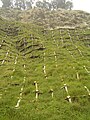 Bracing on the side of a mountain in Chiayi County prevents landslides caused by typhoons.
 -
 Natural-colour satellite image of landslide scarred mountains in central Taiwan.
 -


Flora and fauna

The western mountain forests are very diverse, with several endemic species such as Formosan Cypress (Chamaecyparis formosensis) and Taiwan Fir (Abies kawakamii), while the Camphor Laurel (Cinnamomum camphora) was once also widespread at lower levels (now mostly cleared for agricultural land). Prior to major Taiwanese economic success, the mountainous areas held several endemic animal species and subspecies, such as the Swinhoe's Pheasant (Lophura swinhoii), Taiwan blue magpie (Urocissa caerulea), Formosan Black Bear (Selanarctos thibetanus formosanus), the Formosan Sika Deer (Cervus nippon taiwanensis or Cervus nippon taiouanus) and the Formosan landlocked salmon (Oncorhynchus masou formosanus). A few of these are now extinct, and many others have been designated endangered species.
Seven national parks in Taiwan showcase the diverse terrain, flora and fauna of the archipelago. Kenting National Park on the southern tip of Taiwan contains uplifted coral reefs, moist tropical forest and marine ecosystems. Yushan National Park has alpine terrain, mountain ecology, forest types that vary with altitude, and remains of ancient road. Yangmingshan National Park has volcanic geology, hot springs, waterfalls, and forest. Taroko National Park has marble canyon, cliff, and fold mountains. Shei-Pa National Park has alpine ecosystems, geological terrain, and valley streams. Kinmen National Park has lakes, wetlands, coastal topography, flora and fauna-shaped island. Dongsha Marine National Park has the Pratas reef atolls for integrity, a unique marine ecology, biodiversity, and is a key habitat for the marine resources of the South China Sea and Taiwan Strait.[10]
Taiwan is a center of bird endemism; see Endemic birds of Taiwan for further information.
Natural resources
Natural resources on the islands include small deposits of gold, copper, coal, natural gas, limestone, marble, and asbestos. The island is 55% forests and woodland (mostly on the mountains) and 24% arable land (mostly on the plains), with 15% going to other purposes. 5% is permanent pastures and 1% is permanent crops.
Because of the intensive exploitation throughout Taiwan's pre-modern and modern history, the island's mineral resources (e.g. coal, gold, marble), as well as wild animal reserves (e.g. deer), have been virtually exhausted. Moreover, much of its forestry resources, especially firs were harvested during Japanese rule for the construction of shrines and have only recovered slightly since then. To this day, forests do not contribute to significant timber production mainly because of concerns about production costs and environmental regulations.
Camphor extraction and sugarcane refining played an important role in Taiwan's exportation from the late 19th century through the first half of the 20th century. The importance of the above industries subsequently declined not because of the exhaustion of related natural resources but mainly of the decline of international market demands.
Nowadays, few natural resources with significant economic value are retained in Taiwan, which are essentially agriculture-associated. Domestic agriculture (rice being the dominant kind of crop) and fisheries retain importance to a certain degree, but they have been greatly challenged by foreign imports since Taiwan's accession to the World Trade Organization in 2001. Consequently, upon the decline of subsistent importance, Taiwan's agriculture now relies heavily on the marketing and exportation of certain kinds of specialty fruits, such as banana, guava, lychee, wax apple, and high-mountain tea.
Energy resources

Taiwan has significant coal deposits and some insignificant petroleum and natural gas deposits. As of 2010[update], oil accounts for 49.0% of the total energy consumption. Coal comes next with 32.1%, followed by nuclear energy with 8.3%, natural gas (indigenous and liquefied) with 10.2%, and energy from renewable sources with 0.5%. Taiwan has six nuclear reactors and two under construction.[11] Nearly all oil and gas for transportation and power needs must be imported, making Taiwan particularly sensitive to fluctuations in energy prices. Taiwan is rich in wind energy resources, with wind farms both onshore and offshore, though limited land area favors offshore wind resources.[12] By promoting renewable energy, Taiwan's government hopes to also aid the nascent renewable energy manufacturing industry, and develop it into an export market.[citation needed]
Environmental issues

With its high population density and many factories, some areas in Taiwan suffer from heavy pollution. Most notable are the southern suburbs of Taipei and the western stretch from Tainan to Lin Yuan, south of Kaohsiung. In the past, Taipei suffered from extensive vehicle and factory air pollution, but with mandatory use of unleaded petrol and the establishment of the Environmental Protection Agency, the air quality of Taiwan has improved dramatically.[13] Motor scooters, especially older or cheaper two-stroke versions, which are ubiquitous in Taiwan, also contribute disproportionately to urban air pollution.[14][15]
Other current environmental issues include water pollution from industrial emissions and raw sewage, contamination of drinking water supplies, and trade in endangered species. Though regulation of sulfate aerosol emissions from petroleum production is becoming stringent, acid rain remains to be a threat to the health of the residents and the forests. Scholars in Taiwan point out that more than half of its acid rain is actually brought by monsoon rains from mainland China.
See also
- Geography of Taiwan
- List of mountains of Taiwan
- List of rivers of Taiwan
- List of volcanoes in Taiwan
- List of islands of the Republic of China
- Taiwanese hot springs
- List of metropolitan areas in Taiwan
References
- ^ The land area of Taiwan island proper (Formosa) is 35,980 km2,the total area of the ROC jurisdiction is 36,191 km2.
- ^ Government Information Office, Republic of China (Taiwan). "Geography". Retrieved 2007-05-21.
- ^ National Taiwan Normal University, Geography Department. "Geography of Taiwan: A Summary". Retrieved 2007-05-21.
- ^ "Law on the Exclusive Economic Zone and the Continental Shelf of the Republic of China (中華民國專屬經濟海域及大陸礁層法)". Retrieved 2007-05-21.
- ^ "The Geology of Taiwan". Department of Geology, National Taiwan Normal University.
- ^ "Geology of Taiwan". Department of Geology, University of Arizona.
- ^ "Chapter 1: Geography". The Republic of China Yearbook 2011. Government Information Office, Republic of China (Taiwan).
{{cite book}}: External link in|chapterurl=|chapterurl=ignored (|chapter-url=suggested) (help) - ^ "GSHAP Region 8: Eastern Asia". Global Seismic Hazard Assessment Program.
- ^ Theodorou, Christine; Lee, Andrew (3 March 2010). "6.4-magnitude quake hits southern Taiwan". CNN.com. Retrieved 4 March 2010.
- ^ National Parks of Taiwan
- ^ Energy Statistics Handbook, Bureau of Energy, Ministry of Economic Affairs, 2010.
- ^ "Taiwan's Energy Policy and Supply-Demand Situation". Bureau of Energy, Ministry of Economic Affairs.
- ^ "Taiwan: Environmental Issues". Country Analysis Brief — Taiwan. United States Department of Energy. October 2003. Archived from the original on 7 October 2006. Retrieved 8 March 2006.
The government credits the APC system with helping to reduce the number of days when the country's pollution standard index score exceeded 100 from 7% of days in 1994 to 3% of days in 2001.
- ^ "Taiwan Country Analysis Brief". United States Department of Energy. August 2005. Archived from the original on 2 February 2007.
Taipei has the most obvious air pollution, primary caused by the motorbikes and scooters used by millions of the city's residents.
- ^ Tso, Chunto (2002). "A Viable Niche Market–Fuel Cell Scooters in Taiwan" (PDF). International Journal of Hydrogen Energy. 28 (7): 757–762. doi:10.1016/S0360-3199(02)00245-8.
In Taiwan's cities, the main source of air pollution is the waste gas exhausted by scooters, especially by the great number of two-stroke engine scooters.
External links
- Taiwan Yearbook 2006 -- Geography
- National Parks of Taiwan
- Clip that introduces Taiwan National Parks
- Taiwan datums
| Mountain ranges |
|  |
|---|---|---|
| Plateaus and hill lands | ||
| Plains | ||
| Basins | ||
| Volcano groups | ||
* The place names listed above are mainly romanized as Wade–Giles that used in most of academic articles. | ||
| Sovereign states |
|
|---|---|
| States with limited recognition | |
| Dependencies and other territories | |
| Sovereign states |
|
|---|---|
| States with limited recognition | |
| Dependencies and other territories | |