
Sinai Peninsula: Difference between revisions
No edit summary |
No edit summary |
||
| Line 6: | Line 6: | ||
While the Levant region (present territories of Syria, Lebanon, Palestine and Israel) has historically been the center of conflict between Egypt on the one hand, and one or the other of the states of Mesopotamia (Babylonia, Assyria, Mitanni) or Asia Minor (the Hittite Empire), based largely on its strategic geopolitical location — the Sinai peninsula has remained under permanent Egyptian control since the First Egyptian Dynasty (ca. 3100 BC). In periods of foreign occupation, it was like the rest of Egypt, also occupied and controlled by the Ottoman Empire, and the United Kingdom (which occupied Egypt from 1882 until 1956). [[Israel]] invaded and occupied Sinai during the [[Suez Crisis]] (known in Egypt as the ''Tripartite Aggression'' due to the simultaneous coordinated attack by the UK, France and Israel) of 1956, and during the [[Six Day War]] of 1967. On 6 October 1973, Egypt launched the [[Yom Kippur War|October War]] to liberate the peninsula, which was the site of fierce fighting between Egyptian and Israeli forces. In 1982, after the [[Israel-Egypt Peace Treaty]] of 1979, Israel withdrew from the entirety of Sinai. Today, Sinai has become a [[Tourism in Egypt|tourist destination]] due to its natural setting, rich [[coral reef]]s, and biblical history. [[Mount Sinai]] is one of the most religiously significant places in [[Abrahamic]] faiths. |
While the Levant region (present territories of Syria, Lebanon, Palestine and Israel) has historically been the center of conflict between Egypt on the one hand, and one or the other of the states of Mesopotamia (Babylonia, Assyria, Mitanni) or Asia Minor (the Hittite Empire), based largely on its strategic geopolitical location — the Sinai peninsula has remained under permanent Egyptian control since the First Egyptian Dynasty (ca. 3100 BC). In periods of foreign occupation, it was like the rest of Egypt, also occupied and controlled by the Ottoman Empire, and the United Kingdom (which occupied Egypt from 1882 until 1956). [[Israel]] invaded and occupied Sinai during the [[Suez Crisis]] (known in Egypt as the ''Tripartite Aggression'' due to the simultaneous coordinated attack by the UK, France and Israel) of 1956, and during the [[Six Day War]] of 1967. On 6 October 1973, Egypt launched the [[Yom Kippur War|October War]] to liberate the peninsula, which was the site of fierce fighting between Egyptian and Israeli forces. In 1982, after the [[Israel-Egypt Peace Treaty]] of 1979, Israel withdrew from the entirety of Sinai. Today, Sinai has become a [[Tourism in Egypt|tourist destination]] due to its natural setting, rich [[coral reef]]s, and biblical history. [[Mount Sinai]] is one of the most religiously significant places in [[Abrahamic]] faiths. |
||
==Overview== |
|||
The two governorates of [[North Sinai]] and [[South Sinai]] comprise around 60,000 square kilometres (23,000 sq mi) and have a population (Jan. 2012) of 554,000. This figure rise to 1,400,000 if Western Sinai the parts of the [[Port Said]], [[Ismailia]] and [[Suez]] Governorates lying east of the Suez Canal were to be included. |
|||
| ⚫ | The two governorates of [[North Sinai]] and [[South Sinai]] comprise around 60,000 square kilometres (23,000 sq mi) and have a population (Jan. 2012) of 554,000. This figure rise to 1,400,000 if Western Sinai the parts of the [[Port Said]], [[Ismailia]] and [[Suez]] Governorates lying east of the Suez Canal were to be included. The name Sinai may have been derived from the ancient [[Lunar deity|moon-god]] [[Sin (mythology)|Sin]]<ref>{{cite web|url=http://www.britannica.com/EBchecked/topic/545586/Sinai-Peninsula |title=Sinai Peninsula (peninsula, Egypt) - Britannica Online Encyclopedia |publisher=Britannica.com |accessdate=14 January 2012}}</ref> or from the Hebrew word "Seneh" ({{lang-he|סֶ֫נֶּה}}, ''Senneh'')<ref>{{cite web |url=http://www.jewishencyclopedia.com/view.jsp?artid=817&letter=S&search=horeb |title=Sinai, Mount |publisher=JewishEncyclopedia.com |accessdate=14 January 2012}}</ref> The peninsula acquired the name due to the assumption that a mountain near [[Saint Catherine's Monastery]] is the [[Biblical Mount Sinai]]. However this is contested.<ref>See [[Biblical Mount Sinai]] for a fuller discussion.</ref> Since the arrival of the Bani Sulaiman tribe in the 14th century, its population has consisted largely of desert-dwelling Bedouin Arabs.<ref>The Human Biology of Pastoral Populations - Page 67, William R. Leonard, Michael H. Crawford - 2002</ref> The peninsulas eastern shore seperates the [[Arabian plate]] from the African plate.<ref>Evolution of the Levant Margin and Western Arabia Platform Since the Mesozoic, Catherine Homberg, Martina Bachmann - 2010, p 65</ref> |
||
==Etymology== |
|||
| ⚫ | The name Sinai may have been derived from the ancient [[Lunar deity|moon-god]] [[Sin (mythology)|Sin]]<ref>{{cite web|url=http://www.britannica.com/EBchecked/topic/545586/Sinai-Peninsula |title=Sinai Peninsula (peninsula, Egypt) - Britannica Online Encyclopedia |publisher=Britannica.com |accessdate=14 January 2012}}</ref> or from the Hebrew word "Seneh" ({{lang-he|סֶ֫נֶּה}}, ''Senneh'')<ref>{{cite web |url=http://www.jewishencyclopedia.com/view.jsp?artid=817&letter=S&search=horeb |title=Sinai, Mount |publisher=JewishEncyclopedia.com |accessdate=14 January 2012}}</ref> The peninsula acquired the name due to the assumption that a mountain near [[Saint Catherine's Monastery]] is the [[Biblical Mount Sinai]]. However this is contested.<ref>See [[Biblical Mount Sinai]] for a fuller discussion.</ref> |
||
==History== |
==History== |
||
Revision as of 12:14, 9 July 2014

The Sinai Peninsula or Sinai (/ˈsaɪnaɪ/;[1][2] Arabic: سيناء Sīnāʼ ; Egyptian Arabic: سينا Sīna, IPA: [ˈsiːnæ]) is a triangular peninsula in Egypt about 60,000 km2 (23,000 sq mi) in area. It is situated between the Mediterranean Sea to the north, and the Red Sea to the south, and is the only part of Egyptian territory located in Asia as opposed to Africa, effectively serving as a land bridge between two continents. The bulk of the peninsula is divided administratively into two of Egypt's 27 governorates (with three more straddling the Suez Canal area), and has a population of approximately 1,400,000 people. In addition to its formal name, Egyptians also refer to it asأرض الفيروز (Arḍ ul-Fairūz), "the Land of Turquoise". The ancient Egyptians called it Mafkat, or "land of the green minerals".[3]
While the Levant region (present territories of Syria, Lebanon, Palestine and Israel) has historically been the center of conflict between Egypt on the one hand, and one or the other of the states of Mesopotamia (Babylonia, Assyria, Mitanni) or Asia Minor (the Hittite Empire), based largely on its strategic geopolitical location — the Sinai peninsula has remained under permanent Egyptian control since the First Egyptian Dynasty (ca. 3100 BC). In periods of foreign occupation, it was like the rest of Egypt, also occupied and controlled by the Ottoman Empire, and the United Kingdom (which occupied Egypt from 1882 until 1956). Israel invaded and occupied Sinai during the Suez Crisis (known in Egypt as the Tripartite Aggression due to the simultaneous coordinated attack by the UK, France and Israel) of 1956, and during the Six Day War of 1967. On 6 October 1973, Egypt launched the October War to liberate the peninsula, which was the site of fierce fighting between Egyptian and Israeli forces. In 1982, after the Israel-Egypt Peace Treaty of 1979, Israel withdrew from the entirety of Sinai. Today, Sinai has become a tourist destination due to its natural setting, rich coral reefs, and biblical history. Mount Sinai is one of the most religiously significant places in Abrahamic faiths.
Overview
The two governorates of North Sinai and South Sinai comprise around 60,000 square kilometres (23,000 sq mi) and have a population (Jan. 2012) of 554,000. This figure rise to 1,400,000 if Western Sinai the parts of the Port Said, Ismailia and Suez Governorates lying east of the Suez Canal were to be included. The name Sinai may have been derived from the ancient moon-god Sin[4] or from the Hebrew word "Seneh" (Hebrew: סֶ֫נֶּה, Senneh)[5] The peninsula acquired the name due to the assumption that a mountain near Saint Catherine's Monastery is the Biblical Mount Sinai. However this is contested.[6] Since the arrival of the Bani Sulaiman tribe in the 14th century, its population has consisted largely of desert-dwelling Bedouin Arabs.[7] The peninsulas eastern shore seperates the Arabian plate from the African plate.[8]
History
| Sinai Peninsula in hieroglyphs | |||||||
|---|---|---|---|---|---|---|---|
| |||||||
Biau Bj3w [9] Mining country [9] | |||||||

Sinai was inhabited by the Monitu and was called Mafkat or Country of Turquoise.[10] From the time of the First dynasty or before, the Egyptians mined turquoise in Sinai at two locations, now called by their Arabic names Wadi Maghareh and Serabit el-Khadim. The mines were worked intermittently and on a seasonal basis for thousands of years. Modern attempts to exploit the deposits have been unprofitable. These may be the first historically attested mines.
According to the Jewish tradition the peninsula was crossed by the Israelites during The Exodus from Egypt as detailed in the Hebrew Bible. This included numerous halts over a 40 year period of travel in AM 2448 (1313 BCE) in the Jewish tradition. However, there has not been found any archaeological evidence for large scale nomadic wanderings from that time period.
The peninsula was governed as part of Egypt under the Mamluk Sultanate of Egypt from 1260 until 1517, when the Ottoman Sultan, Selim the Grim, defeated the Egyptians at the Battles of Marj Dabiq and al-Raydaniyya, and incorporated Egypt into the Ottoman Empire. From then until 1906, Sinai was administered by the Ottoman provincial government of the Pashalik of Egypt, even following the establishment of the Muhammad Ali Dynasty's rule over the rest of Egypt in 1805. In 1906, the Ottoman Porte formally transferred administration of Sinai to the Egyptian government, which essentially meant that it fell under the control of the United Kingdom, who had occupied and largely controlled Egypt since 1882. The border imposed by the British runs in an almost straight line from Rafah on the Mediterranean shore to Taba on the Gulf of Aqaba. This line has served as the eastern border of Egypt ever since.
At the beginning of the 1948 Arab-Israeli War, Egyptian forces entered the former British Mandate of Palestine from Sinai to support Palestinian and other Arab forces against the newly declared State of Israel. For a period during the war, Israeli forces entered the north-eastern corner of Sinai. With the exception of Palestine's Gaza Strip, which came under the administration of the All-Palestine Government, the western frontier of the former Mandate of Palestine became the Egyptian-Israeli frontier under the 1949 Armistice Agreement. In 1958, the Gaza Strip came under direct Egyptian military administration, though it was governed separately from Sinai, and was never annexed by Egypt. The Egyptian government maintained that Egyptian administration would be terminated upon the end of the conflict with Israel.
In 1956, Egypt nationalised the Suez Canal, a waterway marking the boundary between Egyptian territory in Africa and the Sinai Peninsula. Thereafter, Israeli ships were prohibited from using the Canal, owing to the state of war between the two states. Egypt also prohibited ships from using Egyptian territorial waters on the eastern side of the peninsula to travel to and from Israel, effectively imposing a blockade on the Israeli port of Eilat. Subsequently, in what is known in Egypt as the Tripartite Aggression, Israeli forces, aided by Britain, and France (which sought to reverse the nationalisation and regain control over the Suez Canal), invaded Sinai and occupied much of the peninsula within a few days. Several months later Israel withdrew its forces from Sinai, following strong pressure from the United States and the Soviet Union. Thereafter, the United Nations Emergency Force (UNEF) was stationed in Sinai to prevent any military occupation of the Sinai.

In 1967, Egypt reinforced its military presence in Sinai, renewed the prohibition of Israeli shipping using Egyptian territorial waters, (including the Suez Canal and western part of the Straits of Tiran), and on 16 May ordered the UNEF out of Sinai with immediate effect. Secretary-General U Thant eventually complied and ordered the withdrawal without Security Council authorisation. Subsequent to Egyptian actions, Israel attacked Egypt, Syria, and Jordan, starting the Six-Day War. Israel captured the entire Sinai Peninsula, and Palestine's Gaza Strip from Egypt, the Palestinian West Bank and East Jerusalem from Jordan (which it had ruled since 1949), and the Golan Heights from Syria. The Suez Canal, the east bank of which was now occupied by Israel, was closed. Israel expelled thousands of Egyptians from Sinai, and commenced efforts at large scale Israeli settlement in the peninsula, concurrently with similar settlement in the Gaza Strip, West Bank, and Golan Heights.
Following the Israeli conquest of Sinai, Egypt launched the War of Attrition aimed at forcing Israel to withdraw from Egyptian territory. The war saw protracted conflict in the Suez Canal Zone, ranging from limited to large scale combat. Israeli shelling of civilian areas in the cities of Port Said, Ismailia, and Suez on the west bank of the canal, led to high civilian casualties (including the virtual destruction of Suez), and contributed to the flight of some one million Egyptian internal refugees. Ultimately, the war concluded in 1970 with no change in the front line.
On 6 October 1973, Egypt commenced Operation Badr to liberate Sinai, while Syria launched a simultaneous operation to liberate the Golan Heights, thereby beginning the Yom Kippur War (known in Egypt as the October War). Egyptian engineering forces built pontoon bridges to cross the Suez Canal, and stormed the supposedly impregnable Bar-Lev Line, Israel's defensive line along the canal. Though the Egyptians maintained control of most of the east bank of the Canal, in the later stages of the war, the Israeli military crossed the southern section of Canal, cutting off the Egyptian 3rd Army, and occupied a section of the west bank. The war ended following a mutually agreed-upon ceasefire. After the war, as part of the subsequent Sinai Disengagement Agreements, Israel withdrew from the Canal, with Egypt agreeing to permit passage of Israeli ships. The canal was reopened in 1975, with President Sadat leading the first convoy through the canal aboard an Egyptian destroyer.
In 1979, Egypt and Israel signed a peace treaty in which Israel agreed to withdraw from the entirety of Sinai. Israel subsequently withdrew in several stages, ending in 1982. The Israeli pull-out involved dismantling almost all Israeli settlements, including the settlement of Yamit in north-eastern Sinai. The exception was the coastal city of Sharm el-Sheikh, which the Israelis had renamed as Ofira during the period of their occupation. The Treaty allows monitoring of Sinai by the Multinational Force and Observers, and limits the number of Egyptian military forces in the peninsula.
In recent years, Sinai has been the site of several terror attacks against tourists, the majority of which are Egyptian. Investigations have showed these were mainly motivated by a resentment of the poverty faced by many Bedouin in the area. Attacking the tourist industry was viewed as a method of damaging the industry so that the government would pay more attention to their situation.[11] (See 2004 Sinai bombings, Sharm el-Sheikh terrorist attacks and 2006 Dahab bombings). Since the 2011 Egyptian Revolution unrest has become more prevalent in the area including the 2012 Egyptian-Israeli border attack in which 16 Egyptian soldiers were killed by militants.
Also on the rise are kidnappings of refugees. According to Meron Estifanos, Eritrean refugees are often kidnapped by Bedouin in the northern Sinai, tortured, raped and only released after having received a large ransom for the kidnappee.[12][13]
Present

Since the Israeli-Egyptian peace treaty, Sinai became a tourist destination due to its natural setting, rich coral reefs, and biblical history. The most popular tourist destination in Sinai are Mount Sinai ("Jabal Musa") and St. Catherine's Monastery, which is considered to be the oldest working Christian monastery in the world, and the beach resorts of Sharm el-Sheikh, Dahab, Nuweiba and Taba. Most tourists arrive at Sharm el-Sheikh International Airport, through Eilat, Israel and the Taba Border Crossing, by train or bus from Cairo or by Ferry from Aqaba in Jordan.
Most of the Sinai Peninsula is divided among two Egyptian governorates, or provinces, named Ganub Sina ("South Sinai") and Shamal Sina ("North Sinai"). Three more governates span the Suez Canal, crossing into African Egypt. el-Sewais ("the Suez") is on the southern end of the Suez Canal, el-Isma'ileyyah in the center, and Port Said in the north.
Approximately 66,500 people live in Ganub Sina and 314,000 live in Shamal Sina. Port Said itself has a population of roughly 500,000 people. Portions of the populations of el-Isma'ileyyah and el-Suweis live in Sinai, while the rest live on the western side of the Suez Canal. The combined population of these two governorates is roughly 1.3 million (only a part of that population live in Sinai, while the rest live on the western side of the Suez Canal). Sinai is one of the coldest provinces in Egypt because of its high altitudes and mountainous topographies. Winter temperatures in some of Sinai's cities and towns reach −16 °C (3 °F).
Large numbers of Egyptians from the Nile Valley and Delta moved to the area to work in tourism, but development adversely affected the native Sinai Bedouin population.[citation needed] In order to help alleviate their problems, various NGOs began to operate in the region, including the Makhad Trust, a UK charity that assists the Bedouin in developing a sustainable income while protecting Sinai's natural environment, heritage and culture.
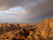
Gallery
-

-

-
 Sand dune and rocky exposure on the Sinai Peninsula
 -
 Mount Sinai ("Gabal Musa")
 -
 Dust Storm in the Peninsula


See also
|
|
References
- ^ "Definition of Sinai". The Free Dictionary. Retrieved 3 May 2014.
- ^ "Define Sinai". Dictionary.com. Retrieved 3 May 2014.
- ^ "ETUDE de la TURQUOISE de ses traitements et imitations", thesis by Claire Salanne, Université de Nantes, 2009.
- ^ "Sinai Peninsula (peninsula, Egypt) - Britannica Online Encyclopedia". Britannica.com. Retrieved 14 January 2012.
- ^ "Sinai, Mount". JewishEncyclopedia.com. Retrieved 14 January 2012.
- ^ See Biblical Mount Sinai for a fuller discussion.
- ^ The Human Biology of Pastoral Populations - Page 67, William R. Leonard, Michael H. Crawford - 2002
- ^ Evolution of the Levant Margin and Western Arabia Platform Since the Mesozoic, Catherine Homberg, Martina Bachmann - 2010, p 65
- ^ a b The translation mining country is not certain, see also Rainer Hannig: Großes Handwörterbuch Ägyptisch-Deutsch : (2800 - 950 v. Chr.). p. 1135.
- ^ Jean Claude Goyon, Christine Cardin, Eds. Joseph Davidovits and Ralph Davidovits Why Djoser's blue Egyptian faience tiles are not blue? Manufacturing Djoser's faience tiles at temperatures as low as 250 °C?. Vol. 1. p. 375.
{{cite book}}:|work=ignored (help)CS1 maint: multiple names: authors list (link) - ^ Serene Assir (23 July 2005). "Shock in Sharm". Al-Ahram Weekly. Retrieved 29 March 2014.
- ^ Meron Stefanos on the torture houses in north Sinai
- ^ Sound of torture documentary
External links
 Sinai Peninsula travel guide from Wikivoyage
- Guide to Sinai, covering background information on history, flora, fauna, desert, bedouin, safaris and geology of Sinai
- Sinai Local Magazine
- The Complete Guide To: The Sinai, The Independent, 15 March 2008.
- Sinai in ancient Egypt
- Broadcasting videos from Sinai
- Images of the Sinai Desert
- Sinais Safari Places[dead link]
- The Path Less Traveled
- IRIN humanitarian news: EU grant to tackle rural poverty in South Sinai
Further reading
- Gardner, Ann "At Home in South Sinai" Nomadic Peoples 2000. Vol. 4,Iss. 2; pp. 48–67. Detailed account of Bedouin women
- H. J. L. Beadnell (May 1926). "Central Sinai". Geographical Journal. 67 (5): 385–398. doi:10.2307/1782203. JSTOR 1782203.
- C. W. Wilson (1873). "Recent Surveys in Sinai and Palestine". Journal of the Royal Geographical Society of London. 43: 206–240. doi:10.2307/1798627. JSTOR 1798627.
- Jacobs, Jessica (2006). "Tourist Places and Negotiating Modernity: European Women and Romance Tourism in the Sinai". In Minca, Claudio; Oakes, Tim (eds.). Travels in Paradox: Remapping Tourism. Rowman & Littlefield. ISBN 978-0-7425-2876-5. Retrieved 7 January 2010.
- Haubitz, Zoche (2006). Sinai Hotels. Fotohof. ISBN 978-3-901756-64-1. Retrieved 7 January 2010.[dead link]
- Teague, Matthew; Moyer, Matt (March 2009). "The Sinai's Separate Peace". National Geographic Magazine. 215 (3). Washington, D.C.: National Geographic Society: 99–121. ISSN 0027-9358. Retrieved 7 January 2010.