
Harry Evans Covered Bridge
The Harry Evans Covered Bridge is a single span Burr Arch Truss structure that crosses Rock Run built in 1908 by J.A. Britton 1⁄2 mi (0.80 km) north of Coxville, Indiana.[1]
History
The story goes that one of the former neighbors of the bridge was incensed over naming the bridge after local resident Harry Evans. He claimed that because Harry lived at the top of the hill that it was named after another Evans who lived in the valley. However, county records show that Harry Evans owned the land near the bridge. The land stayed in the Evans name until the 1960s.[2]
It was added to the National Register of Historic Places in 1978.[3] The hills near the bridge are also riddled with numerous, and dangerous, old coal mines.[1]
Gallery
-
 Side view of the Harry Evans Bridge
 -
 Information Plaque
 -
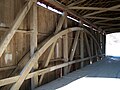 Interior of the Harry Evans Bridge


See also
- List of Registered Historic Places in Indiana
- Parke County Covered Bridges
- Parke County Covered Bridge Festival
References
- ^ a b "Harry Evans Covered Bridge (#19)". coveredbridges.com. Parke County Incorporated /Parke County Convention and Visitors Commission. Retrieved 20 September 2016.
- ^ "Indiana State Historic Architectural and Archaeological Research Database (SHAARD)" (Searchable database). Department of Natural Resources, Division of Historic Preservation and Archaeology. Retrieved 2016-06-01. Note: This includes Charles Felkner (December 1977). "National Register of Historic Places Inventory Nomination Form: Parke County Covered Bridge Historic District" (PDF). Retrieved 2016-06-01., Site map, and Accompanying photographs.
- ^ Cite error: The named reference
nriswas invoked but never defined (see the help page).
External links


This article about a bridge in Indiana is a stub. You can help Wikipedia by expanding it. |
- Covered bridges on the National Register of Historic Places in Parke County, Indiana
- Covered bridges in Parke County, Indiana
- Bridges completed in 1908
- Road bridges in Indiana
- Historic district contributing properties in Indiana
- Road bridges on the National Register of Historic Places in Indiana
- 1908 establishments in Indiana
- Wooden bridges in Indiana
- Burr Truss bridges in the United States
- Midwestern United States bridge (structure) stubs
- Indiana building and structure stubs
- Indiana transportation stubs
- Central Indiana Registered Historic Place stubs