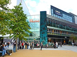
Westfield Stratford City
 | |
 | |
 | |
| Location | Stratford, London, England, United Kingdom |
|---|---|
| Opening date | 13 September 2011[1] |
| Management | Unibail-Rodamco-Westfield |
| Owner | Unibail-Rodamco-Westfield (50%) ABP Pension Fund (25%) CPP Investment Board (25%)[2] |
| No. of stores and services | 350 |
| No. of anchor tenants | 3 (Marks & Spencer, John Lewis & Waitrose) |
| Total retail floor area | 175,000 square metres (1,880,000 sq ft)[3] |
| No. of floors | 3 (some shops have extra floors) |
| Parking | 5,000[4] |
| Public transit access | |
| Website | westfield.com/stratfordcity |


Westfield Stratford City[5] is a shopping centre in Stratford, East London, which opened on 13 September 2011.[6][7] With a total retail floor area of 1,910,000 square feet (177,000 m2),[3] it is the largest urban shopping centre in the UK by land area and the 4th-largest shopping centre in the UK by retail space, behind Westfield London (White City), the MetroCentre, and the Trafford Centre. [8][9][10]
Originally fully owned by the Westfield Group, in November 2010 ABP Pension Fund and CPP Investment Board each purchased a 25% shareholding, with Westfield retaining 50%.[11] Westfield's holding is now owned by Unibail-Rodamco-Westfield following Unibail-Rodamco's acquisition of Westfield Corporation in 2018.
Westfield Stratford City is adjacent to the London Olympic Park, Stratford Cross, East Village, Stratford Regional and Stratford International stations. The shopping centre is part of a large multi-purpose development project called Stratford City. It is promoted as contributing significantly to the local economy, with the creation of up to 10,000 permanent jobs including 2,001 going to local people.[5] However, there are counter-reports of significant harm to other local businesses due to the preponderance of chain stores.[12]
The site was formerly occupied by Stratford Works and Locomotive Depot.
Retail area
[edit]The shopping centre is anchored by a 240,000 sq ft (22,000 m2) John Lewis department store, a 32,000 sq ft (3,000 m2) Waitrose supermarket, a 136,000 sq ft (12,600 m2) Marks & Spencer department store, a 24-hour casino (Aspers) and a 20 screen all-digital Vue cinema.[13] The shopping centre also has a 267-room Premier Inn hotel,[14] a Holiday Inn with 350 rooms[5][15] and Staybridge Suites. The shopping centre has approximately 280 stores and 70 restaurants.[16][17]
Transport
[edit]To the south of the site lies Stratford station which is served by London Underground's Central and Jubilee lines, Greater Anglia, Elizabeth line, London Overground, Docklands Light Railway, and a number of c2c services. To the north lies Stratford International station, which is served by Southeastern High Speed and Docklands Light Railway services.
Stratford bus station and Stratford City bus station are served by numerous London Buses routes[18][19] and National Express and Terravision long-distance services.
According to Westfield, while the site supports a 5,000 space car park, 80% of the shoppers arrive at the centre on public transport.[4]
In popular culture
[edit]In 13 September 2011, Nicole Scherzinger marked the opening of Westfield Stratford City with a performance.[20]
In January 2012, The X Factor singer Olly Murs filmed a music video for his single "Oh My Goodness" at Westfield Stratford City.[21]
See also
[edit]References
[edit]- ^ "Westfield Group Press Release". Westfield UK. Retrieved 14 September 2011.
- ^ "Westfield Group to Sell 50% Interest in Retail Component of Stratford City for £871.5 Million". CPP Investment Board. Retrieved 27 August 2012.
- ^ a b "Westfield Group Property Portfolio: Stratford City Overview". Westfield UK. Archived from the original on 19 October 2011. Retrieved 14 September 2011.
- ^ a b "Games gloom: Car park closure 'devastating'". The Guardian. 23 June 2012.
- ^ a b c "Press Toolkit". uk.westfield.com. Retrieved 7 September 2011.
- ^ "Launch date announced for Mega Mall". thisisLondon. Retrieved 7 September 2011.
- ^ "Westfield Stratford City: Opening date". uk.westfield.com. Retrieved 16 April 2011.
- ^ "Olympic shopping centre is opened". BBC News. 13 September 2011. Retrieved 9 April 2018.
- ^ "£20m spent in first week at Westfield Stratford City - News". London24. 21 September 2011. Retrieved 4 November 2013.
- ^ Barrett, Claer; Felsted, Andrea (13 September 2011). "Europe's biggest shopping centre opens". Financial Times. Archived from the original on 11 December 2022. Retrieved 9 April 2018.
- ^ Spybey, Kat (22 November 2010). "Westfield sells 50% of Stratford City for 872m to APG and CPPIB". Property Week.
- ^ "New Olympic Westfield leaves local traders fighting for survival - Business - London Evening Standard". Standard.co.uk. 3 January 2012. Retrieved 4 November 2013.
- ^ "Westfield Stratford City Cinema". uk.westfield.com. Retrieved 18 March 2020.
- ^ "Premier Inn News Release". Premier Inn.
- ^ "Masterplan". uk.westfield.com. Retrieved 7 September 2011.
- ^ "What's here". www.westfieldstratfordcity2011.com. Retrieved 7 September 2011.
- ^ "Westfield Stratford City Sign Inditex Trio". uk.westfield.com. Retrieved 7 September 2011.
- ^ "Buses from Stratford" (PDF). Transport for London. February 2009. Retrieved 27 May 2009.
- ^ "Night buses from Stratford" (PDF). Transport for London. 2009. Retrieved 27 May 2009.
- ^ "Westfield Stratford opening". Newham recorder. 13 September 2011. Retrieved 28 April 2019.
- ^ "Olly Murs Shoots New Music Video At Westfield Stratford". Capital FM. 17 January 2012. Retrieved 4 November 2013.


