Huron County, Ohio
Huron County | |
|---|---|
 Location within the U.S. state of Ohio | |
 Ohio's location within the U.S. | |
| Coordinates: 41°09′N 82°36′W / 41.15°N 82.6°W | |
| Country | |
| State | |
| Founded | March 7 1809[1] |
| Named for | the Huron tribe |
| Seat | Norwalk |
| Largest city | Norwalk |
| Population (2000) | |
| • Total | 59,487 |
| Time zone | UTC−5 (Eastern) |
| • Summer (DST) | UTC−4 (EDT) |
| Website | www |
Huron County is a county located in the state of Ohio, United States. As of 2000, the population was 59,487. Its county seat is Norwalk.6 The county was named in honor of the Huron Indians who once lived in the Great Lakes region. The word "Huron" may be French, although this origin is disputed.[2] The county lies in the former Connecticut Western Reserve and more specifically, in a subregion called the Firelands.
Geography
According to the U.S. Census Bureau, the county has a total area of 1,281 km² (495 mi²). 1,276 km² (493 mi²) of it is land and 5 km² (2 mi²) of it (0.37%) is water.
Adjacent counties
- Erie County (north)
- Lorain County (east)
- Ashland County (southeast)
- Richland County (south)
- Crawford County (southwest)
- Seneca County (west)
- Sandusky County (northwest)
Demographics
As of the census² of 2000, there were 59,487 people, 22,307 households, and 16,217 families residing in the county. The population density was 47/km² (121/mi²). There were 23,594 housing units at an average density of 18/km² (48/mi²). The racial makeup of the county was 95.98% White, 0.97% Black or African American, 0.18% Native American, 0.25% Asian, 0.01% Pacific Islander, 1.63% from other races, and 0.99% from two or more races. 3.56% of the population were Hispanic or Latino of any race.
There were 22,307 households out of which 36.30% had children under the age of 18 living with them, 58.50% were married couples living together, 10.40% had a female householder with no husband present, and 27.30% were non-families. 23.10% of all households were made up of individuals and 9.70% had someone living alone who was 65 years of age or older. The average household size was 2.64 and the average family size was 3.11.
In the county, the population was spread out with 28.30% under the age of 18, 8.50% from 18 to 24, 28.90% from 25 to 44, 21.90% from 45 to 64, and 12.40% who were 65 years of age or older. The median age was 35 years. For every 100 females there were 96.10 males. For every 100 females age 18 and over, there were 92.90 males.
The median income for a household in the county was $40,558, and the median income for a family was $46,911. Males had a median income of $35,760 versus $22,785 for females. The per capita income for the county was $18,133. About 6.50% of families and 8.50% of the population were below the poverty line, including 11.00% of those under age 18 and 7.70% of those age 65 or over.
Government

Main article: Ohio county government.
The Willard Memorial Library serves the communities of Huron County from its administrative offices in Willard, Ohio and branches in Greenwich, North Fairfield and Wakeman. In 2005, the library loaned more than 196,000 items to its 19,000 cardholders. Total holdings in 2005 were over 83,000 volumes with over 120 periodical subscriptions.
Localities
Municipalities
Townships
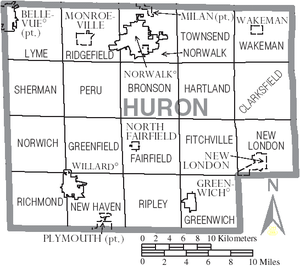
Huron County is subdivided into 19 townships:
Unincorporated places
|
|
|
Education
References
- ^ "Ohio County Profiles: Huron County" (PDF). Ohio Department of Development. Retrieved 2007-04-28.
- ^ "Huron County data". Ohio State University Extension Data Center. Retrieved 2007-04-28.
- Huron County Auditor
- Huron County Board of MRDD
- Huron County Clerk
- Huron County Commissioners
- Huron County Development Council
- Huron County Emergency Management Agency
- Huron County Fair Board
- Huron County General Health District
- Huron County Juvenile & Probate Court
- Huron County Soil & Water Conservation District
- Norwalk-Huron County Airport


