Ponmudi Dam
| Ponmudi Dam | |
|---|---|
 Ponmudi Dam and Reservoir | |
| Location | Idukki, Kerala, India |
| Coordinates | 9°57′1″N 77°3′37″E / 9.95028°N 77.06028°E |
| Opening date | 1963 |
| Operator(s) | Kerala State Electricity Board, Government of Kerala |
| Dam and spillways | |
| Impounds | Panniar River |
| Height | 59 metres (194 ft) |
| Length | 294 metres (965 ft) |
| Reservoir | |
| Total capacity | 51,540,000 cubic metres (1.820×10⁹ cu ft) |
| Surface area | 278.9 hectares (689 acres) |
| Power Station | |
| Turbines | 2x16 MW |
| Installed capacity | 32 MW |
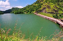
The Ponmudi Dam, in the Idukki district, State of Kerala, India, is a hydroelectric project constructed across the Panniar River, a tributary of the Periyar River which is the longest river in Kerala. Built in 1963, it has a length of 294 metres (965 ft). The hydropower component of the dam has an installed capacity of 30 MW with firm power of 17 MW, generating 158 GWh annually.[1]
Location
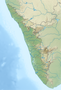
The dam, located near Munnar on the Panniar River in the Periyar River valley in Kerala, is part of the basin of the West flowing rivers of the Tadri to Kanyakumari. The nearest city is Udumbanchola.[1][2] Mattupetty to Ponmudi Dam is a distance of 39 kilometres (24 mi).[3]
Features
The Ponmudi Dam is a masonry gravity dam of 59 metres (194 ft) height with a total length of 294 metres (965 ft). At the Full Reservoir Level, the gross storage capacity of the reservoir is 51,540,000 cubic metres (1.820×10⁹ cu ft) and live storage is 47,400,000 cubic metres (1.67×10⁹ cu ft). The dam has a total volumetric content of 181,000 cubic metres (6,400,000 cu ft). The dam is located in Seismic Zone-III. The reservoir water spread area or submergence area is 2.79 square metres (30.0 sq ft). The spillway is designed for a design discharge of 1,416.03 cubic metres (50,007 cu ft) per second. The flood discharge is routed through a spillway which is fitted with three radial gates, each 10.9728 by 6.4008 metres (36.000 ft × 21.000 ft).[1][4][5] The stored water is diverted through a tunnel of 3,066 metres (10,059 ft) for power generation creating a head of 220 metres (720 ft).[4][6]
Hydro power development
The water stored in the reservoir is utilized for power generation by diverting the flows through a 3,066-metre (10,059 ft) tunnel[7] followed by two lines of penstock pipes each with a diameter of 1.7 metres (5 ft 7 in) and a length of 762 metres (2,500 ft). The two penstock pipe lines are designed to carry a discharge of 17.88 cubic metres (631 cu ft) per second. The power station located at Panniyar is provided with installation of 30 MW comprising two units, each of 15 MW capacity Francis turbines. The firm power generation is 17 MW and the annual power generated is 158 GWh. The first unit was commissioned on 29 December 1963 and the second unit on 26 January 1964. The units were renovated in 2001 and 2003.[4][8]
Major disaster
In a major disaster at the project site, which occurred 17 September 2007, one of the penstock valves burst causing the death of 7 people, destroying 15 houses, and damaging 150 acres (61 ha) of crops. The reason attributed to the pipe burst is the loosening of the flange bolt connection. The damaged valve was rectified in July 2009.[4][9][10]
References
- ^ a b c "Ponmudi (Eb) D03300". Government of India.
- ^ "Geography". National Information Centre.
- ^ "Mattupetty to Ponmudi Dam". Distancemonk.com.
- ^ a b c d "Indentifiers for Hydro: Panniyar Hydroelectric Power Plant India". Government of Kerala. Archived from the original on 1 December 2010. Retrieved 24 May 2015.
- ^ "Table 1.1 Important Reservoirs on the Periyar and Chakkodi River basins" (pdf). Shodhganga Inflibnet Centre.
- ^ Kerala (India); A. Sreedhara Menon (1975). Kerala District Gazetteers: Quilon. Superintendent of Government Presses. p. 181.
- ^ Irrigation & Power: The Journal of the Central Board of Irrigation & Power. The Board. 1962.
- ^ "Panniyar Power House PH01241". Government of India.
- ^ "Major Accidents In India Due To Negligence In Dam Safety / 1979 – 2014" (PDF). NAPM – National Alliance of People's Movements. Archived from the original (pdf) on 24 May 2015. Retrieved 24 May 2015.
- ^ "Idukki dam pipe burst: Toll rises to 4". Rediff.com. 18 September 2007.


