Ohio's 4th congressional district
| Ohio's 4th congressional district | |
|---|---|
 Ohio's 4th congressional district - since January 3, 2013. | |
| Representative | |
| Distribution |
|
| Population (2018) | 707,219[2] |
| Median household income | $55,425[3] |
| Ethnicity |
|
| Cook PVI | R+14[4] |
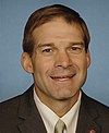
Ohio's 4th congressional district spans sections of the northeast, central, and southwest areas of the state.[5] Its nickname, "the duck district," refers to its geographical shape being similar to a duck.[6][7] The district zig-zags west and south from Cleveland's suburbs to Mercer County on the Indiana border. The largest city in the district is Elyria.[8] It also includes Oberlin, home of Oberlin College.[9] It is currently represented by Republican Jim Jordan, who has represented the district since 2007.[10]
Cities and towns represented
History of district boundaries
From 2002 to 2012 the district included the counties of Allen, Auglaize, Champaign, Hancock, Hardin, Logan, Marion, Morrow, Richland, Shelby, and part of Wyandot.[citation needed]
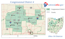
As part of the 2010 redistricting process, it was redrawn from the previous district to stretch from Lima, to include the northwestern suburbs of Columbus, up to Tiffin and Elyria on the shores of Lake Erie.[citation needed]
In May 2019, a panel of three federal judges ruled that Ohio's congressional district map was unconstitutional and based on gerrymandering. A new map was expected ahead of the 2020 election.[11] However, after the U.S. Supreme Court ruled in Rucho v. Common Cause that courts could not review allegations of gerrymandering, the district boundaries will not change until congressional district maps are redrawn in 2022.[12]
List of members representing the district
Recent election results
Election results from presidential races
| Year | Office | Result |
|---|---|---|
| 2000 | President | George W. Bush 62% - Al Gore 35% |
| 2004 | President | George W. Bush 65% - John Kerry 34% |
| 2008 | President | John McCain 54.4% - Barack Obama 43.7% |
| 2012 | President | Mitt Romney 56% - Barack Obama 42% |
| 2016 | President | Donald Trump 64.3% - Hillary Clinton 30.7% |
See also
References
- ^ https://www.census.gov/geo/maps-data/data/cd_state.html
- ^ https://www.census.gov/mycd/?st=39&cd=04
- ^ https://www.census.gov/mycd/?st=39&cd=04
- ^ "Partisan Voting Index – Districts of the 115th Congress" (PDF). The Cook Political Report. April 7, 2017. Archived from the original (PDF) on June 7, 2017. Retrieved April 7, 2017.
- ^ "Census.gov: Ohio 4th congressional district" (PDF). census.gov. 2013.
{{cite web}}: CS1 maint: url-status (link) - ^ "How GOP gerrymandering cracked northwest Ohio and what happens next". Toledo Blade. Retrieved 2019-11-13.
- ^ "Ohio voters may change way Congress districts drawn". The Lima News. 2017-12-28. Retrieved 2019-11-13.
- ^ "What Will It Take To Get Jim Jordan Out Of Congress?". Deadspin. Retrieved 2019-11-13.
- ^ Schultze, M. L. "How Did Ohio's Most Liberal City End Up With Its Most Conservative Congressman?". www.wksu.org. Retrieved 2019-11-13.
- ^ "Rep. Jim Jordan Denies He Knew Of Decades-Long Sexual Abuse At Ohio State". NPR.org. Retrieved 2019-11-13.
- ^ Exner, Rich (2019-05-03). "Federal judges toss out Ohio's congressional map as illegal gerrymander". cleveland. Retrieved 2019-11-13.
- ^ Balmert, Jessie; Borchardt, Jackie (2019-06-27). "No new maps for Ohio till 2022 after U.S. Supreme Court gerrymandering decision". Retrieved 2020-02-08.
- ^ a b c d e our campaigns OH - District 4 - History
- ^ "2012 Election Results". Ohio Secretary of State.
- Martis, Kenneth C. (1989). The Historical Atlas of Political Parties in the United States Congress. New York: Macmillan Publishing Company.
{{cite book}}: Cite has empty unknown parameter:|coauthors=(help) - Martis, Kenneth C. (1982). The Historical Atlas of United States Congressional Districts. New York: Macmillan Publishing Company.
{{cite book}}: Cite has empty unknown parameter:|coauthors=(help) - Congressional Biographical Directory of the United States 1774–present


