
Munnar
Munnar is a town and hill station located in the Idukki district of the southwestern Indian state of Kerala. Munnar is situated at around 1,600 metres (5,200 ft) above mean sea level,[1] in the Western Ghats mountain range. Munnar is also called the "Kashmir of South India" and is a favorite destination for honeymoon.
[2]History
The tradition that Col Arthur Wellesley, later to be the Duke of Wellington, leading a British detachment from Vandiperiyar to Bodinayakanur, then over the High Range and into the Coimbatore plains to cut off Tippu Sultan's retreat from Travancore, was the first Englishman in the High Range appears to be believed by the dates involved. If the story is a dozen years too early for Wellesley, it is quite possible that some other officer in General Meadow's Army may have had that distinction. Unfortunately, no record of that pioneering mountain crossing has been traced. What is available is a record of the surveying of this terrain in 1816-17 by Lt Benjamin Swayne Ward, son of Col Francis Swayne Ward to whom we owe many of the early views of Madras and South India now available in lithprints.
Ward and his assistant Lt Eyre Connor were on orders to map the unexplored country between Cochin and Madurai and so they followed the Periyar into the mountains and then headed north into what at that time was described as "the dark impenetrable forests of the High Range". They lost men to at least one elephant charge, suffered agony from leech bites and once ran so short of food that a deer run down and being feasted on by wild dogs was manna for the party and their jungle guides. The subsequent report by Ward and Connor was to lead to the Periyar Dam Project, completed only in the 1890s, but for the present they were more pre-occupied getting into the mountains that they could see towering in the distance from Bodi. Then. on October 14, 1817, "The weather having improved the ascent into the High Range began".
Their first major camp was at a flat promontory at 6000 feet. And this was ever afterwards to be known as Top Station. Moving North, they saw to their south the Cardamom Hills, a slope 45 miles long and 30 wide from the heights above Bodi stretching into Travancore. To their north there appeared to be grasslands on high rock peaks. And in front of them, "an outstanding mountain, shaped like elephant's head". On November 8, they established camp at the confluence of three rivers, which they judged to be the centre of the district, and from Munnar (Moonar - three rivers), as it came to be known, they surveyed the area, discovered the ancient village of Neramangalam in ruins but surmised that it might well have been from here that ivory and peacock feathers, pepper and cardamom, sandalwood and other timber went to the lands to the West across the Arabian Sea.
It was to be nearly 50 years later that Sir Charles Trevelyan, Governor of Madras, instructed Col Douglas Hamilton to explore the hill country in the western part of the Madras Presidency, requesting special advice on the feasibility of establishing sanatoria for the British in the South and of developing revenue-earning projects without endangering the environment, as had happened in Ceylon where coffee had destroyed not only the rain forest but also paddy cultivation in the north-central rice bowl of ancient Ceylon.
Marching south along the Anamallai, Hamilton saw "the grandest and most extensive (view) I have ever beheld; some of the precipices are of stupendous magnitude and the charming variety of scenery comprising undulating grassy hills, wooded valleys, rocky crags, overhanging precipices, the green rice fields far below in the valley on the Anchanad, the grand mass of the Pulunies (beyond) and the blue ranges in the far distance, present a view far beyond my power to describe....."
Etymology
The name Munnar is believed to mean "three rivers",[3] referring to its location at the confluence of the Mudhirapuzha, Nallathanni and Kundaly rivers.[4]
Location
Geographic coordinates of Munnar is 10°05′21″N 77°03′35″E. Munnar town is situated on the Kannan Devan Hills village in Devikulam taluk and is the largest panchayat in the Idukki district covering an area of nearly 557 square kilometres (215 sq mi).[citation needed]
Road

Munnar is well connected by both National highways, state highways and rural roads. The town lies in the Kochi - Dhanushkodi National highway (N.H 49), about 130 km (81 mi) from Cochin, 31 km (19 mi) from Adimali, 85 km (53 mi) from Udumalpettu in Tamil Nadu and 60 km (37 mi) from Neriyamangalam.
Distance from major cities
- from Kochi - Ernakulam - 150 km
Railway
The nearest major railway stations are at Ernakulam and Aluva (approximately 140 kilometres (87 mi) by road). The Nearest Functioning Railway station is at Udumalaipettai.
Airport
The nearest airport is Cochin International Airport, which is 110 kilometres (68 mi) away. The Coimbatore and Madurai airports is Template:Nowrap165 kilometres (103 mi) from Munnar.
Administration
The panchayath of Munnar formed in 1961 January 24 is divided into 21 wards for administrative convenience. Coimbatore district lies in the north, Pallivasal in south, Devikulam and Marayoor in east and Mankulam, Kuttampuzha panchayaths in the west.
- Vaguvarai
- Chokkanad
- Iravikulam
- Kannimalai
- Periyavarai
- Munnar colony
- Ikkanagar
- Old Munnar
- Chatta Munnar
- Nallathanni
- Sivanmalai
- Munnar town
- Cholamalai
- Kadalar
- Rajamalai
- Kallar
- Lakkam
- Thalayar
- Lakshmi
- Nadayar
- Moolakkada
Flora and fauna
Most of the native flora and fauna of Munnar have disappeared due to severe habitat fragmentation resultant from the creation of the plantations. However, some species continue to survive and thrive in several protected areas nearby, including the new Kurinjimala Sanctuary to the east, the Chinnar Wildlife Sanctuary, Manjampatti Valley and the Amaravati reserve forest of Indira Gandhi Wildlife Sanctuary to the north east, the Eravikulam National Park and Anamudi Shola National Park to the north, the Pampadum Shola National Park to the south and the proposed Palani Hills National Park to the east.
Endemic species

These protected areas are especially known for several threatened and endemic species including Nilgiri Thar, the grizzled giant squirrel, the Nilgiri wood-pigeon, elephant, the gaur, the Nilgiri langur, the sambar, and the neelakurinji (that blossoms only once in twelve years). [5][6]
Land ownership
There has been action to address the problems of property takeovers by the land mafia that have, according to successive governments, plagued the area. In 2011, the government estimated that 20,000 hectares of land had been illegally appropriated and launched a campaign of evictions that had first been mooted in 2007.[7]
Places of interest
There are four major directions are there in Munnar. Mattupatty Direction, Thekkedy Direction, Adimaly Direction and Coimbatore Direction. Climate and Tea Plantation is the base for Munnar Tourism. Tourists come here to see the plush green carpet that is strewn all around. The tourists count increases per year with a major number during the months of April – May when summer vacations begin across the country. In 2018, a huge number of tourists is expected during the months of August- September when the kurinji blooms once in 12 years.
Mattupatty Direction
Thekkedy Direction
- Signal Point View Point
- Idly Hill View Point
- Devikulam Sri Ayyappan Temple
- Munnar Heritage Tour, Lockhart Tea Factory
- Lockhart Tea Museum[8][1]
- Lockhart Tea Park
- Chokarmudy Trekking
- Thankaiah Cave
- Lockhart Gap View Point
- Periyakanal Water Falls
- Anayirangal Dam / Boating
Adimaly Direction
Coimbatore Direction
Other Direction
Geography and climate
The region in and around Munnar varies in height from 1,450 meters (4,760 ft) to 2,695 meters (8,842 ft) above mean sea level. The temperature ranges between 5 °C (41 °F) and 25 °C (77 °F) in winter and 15 °C (59 °F) and 25 °C (77 °F) in summer.[9] Temperatures as low as −4 °C (25 °F) have been recorded in the Sevenmallay region of Munnar.[10][failed verification]
Köppen-Geiger climate classification system classifies it as subtropical highland (Cwb).[11]
| Climate data for Munnar | |||||||||||||
|---|---|---|---|---|---|---|---|---|---|---|---|---|---|
| Month | Jan | Feb | Mar | Apr | May | Jun | Jul | Aug | Sep | Oct | Nov | Dec | Year |
| Mean daily maximum °C (°F) | 22.4 (72.3) |
23.7 (74.7) |
25.3 (77.5) |
25.6 (78.1) |
25.6 (78.1) |
23.7 (74.7) |
22.4 (72.3) |
22.8 (73.0) |
23.2 (73.8) |
22.7 (72.9) |
21.8 (71.2) |
21.9 (71.4) |
23.4 (74.2) |
| Daily mean °C (°F) | 17.6 (63.7) |
18.7 (65.7) |
20.2 (68.4) |
21 (70) |
21.4 (70.5) |
20.3 (68.5) |
19.3 (66.7) |
19.5 (67.1) |
19.6 (67.3) |
19.2 (66.6) |
18.3 (64.9) |
17.7 (63.9) |
19.4 (66.9) |
| Mean daily minimum °C (°F) | 12.9 (55.2) |
13.7 (56.7) |
15.1 (59.2) |
16.5 (61.7) |
17.3 (63.1) |
16.9 (62.4) |
16.3 (61.3) |
16.3 (61.3) |
16 (61) |
15.7 (60.3) |
14.8 (58.6) |
13.5 (56.3) |
15.4 (59.8) |
| Average precipitation mm (inches) | 18 (0.7) |
29 (1.1) |
47 (1.9) |
129 (5.1) |
189 (7.4) |
420 (16.5) |
583 (23.0) |
364 (14.3) |
210 (8.3) |
253 (10.0) |
164 (6.5) |
64 (2.5) |
2,470 (97.3) |
| Average rainy days | 2 | 2 | 3 | 6 | 8 | 9 | 10 | 9 | 10 | 12 | 8 | 5 | 84 |
| Mean monthly sunshine hours | 248 | 232 | 248 | 240 | 217 | 120 | 124 | 124 | 150 | 155 | 180 | 217 | 2,255 |
| Source 1: Climate-Data.org, altitude: 1461m[11] | |||||||||||||
| Source 2: Weather2Travel for sunshine and rainy days[12] | |||||||||||||

Gallery
-
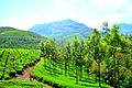 Tea plantations at Munnar
 -
 Munnar Tea Museum
 -
 Beautiful view of Munnar tea plantation
 -
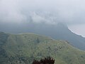 Mountain ranges covered by clouds at Munnar
 -
Tea plantations at Munnar
-
 Munnar Heritage Tour, Lockhart Tea Factory
 -
 Nilgiri Thar
 -
 Lockhart Plantation Museum
 -
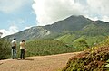 Chokarmudy View Point
 -
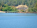 Kundala Dam and Lake
 -
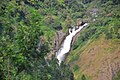 Attukad Water Falls
 -
 Lockhart Tea Park

_(13694719014).jpg)


See also
- Bisonvalley
- Kolukkumalai
- Kunchithanny
- Marayur
- Mattupetty Dam
- Munnar Tea Museum
- Pallivasal
- Rajakkad
- Wayanad
References
- ^ Munnar - the Hill Station of Kerala in Idukki | Kerala Tourism
- ^ S, Muthiah (1993). A Planting Century. Madras: East-West Pvt Ltd. pp. 59–72. ISBN 81 85938 04 0.
- ^ Munnar History Archived 5 February 2012 at the Wayback Machine
- ^ "Munnar".
- ^ "Government of Kerala, Forest and Wildlife Department, Notification No. 36/2006 F&WLD". Kerala Gazette. 6 October 2006. Retrieved 2007-12-05.
- ^ Roy, Mathew (25 September 2006). "Proposal for Kurinjimala sanctuary awaits Cabinet nod". The Hindu. Retrieved 2007-12-05.
- ^ Jacob, Jeemon (12 July 2011). "Kerala government launches eviction drive in Munnar". Retrieved 2014-07-10.
- ^ "Lockhart Tea Museum".
{{cite web}}: Cite has empty unknown parameter:|dead-url=(help) - ^ "Eravikulam National Park, Munnar, Kerala, India, the home of Nilgiri Tahr". Eravikulam National Park. Archived from Eravikulam the original on 12 May 2006. Retrieved 28 August 2013.
{{cite web}}: Check|url=value (help); Unknown parameter|deadurl=ignored (|url-status=suggested) (help) - ^ Frost hits plantations in Munnar[failed verification]
- ^ a b "Climate: Munnar — Climate graph, Temperature graph, Climate table". Climate-Data.org. Retrieved 2013-08-28.
- ^ "Munnar Climate and Weather Averages, Kerala". Weather2Travel. Retrieved 2013-08-28.
External links
![]() Munnar travel guide from Wikivoyage
Munnar travel guide from Wikivoyage
