
Varzahan Monastery
| Varzahan | |
|---|---|
 Varzahan Monastery in 1911. | |
| Religion | |
| Affiliation | Armenian Apostolic Church |
| Status | demolished sometime between the 1920s and the mid-1950s[1] |
| Location | |
| Location | near Uğrak village |
 Shown within Turkey | |
| Geographic coordinates | 40°20′00″N 40°07′00″E / 40.333333°N 40.116667°E |
| Architecture | |
| Style | Armenian |
| Completed | 12th century |
Varzahan (Armenian: Վարզահան վանք, Turkish: Uğrak Kiliseleri or Varzahan Kiliseleri), was an Armenian church founded in the 12th century near village Uğrak (formerly Varzahan), 10 km northwest of Bayburt, in eastern Turkey.
History
Situated in a settlement called Varzahan in Upper Armenia province of Historical Armenia's northern part. Varzahan was a large Armenian settlement in a 5.7 miles northwest to the Baberd city ( now Bayburt ) of a northernmost district of Upper Armenia called Sper. Most of its population was massacred by Turks during the 18th century. The monastery was damaged in the same period. The archaeologist Austin Henry Layard has described this place in 1849 while travelling from Trebizond to Mosul. Austin Henry Layard said:
---The only place of any interest, passed during our ride, was a small Armenian village, the remains of a larger, with the ruins of three early Christian churches, or Baptisteries.---
Gallery
-
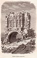
 Lynch's 1898 photograph of the graveyard.
 -
 A drawing of one of the churches.


Ruines d'eglise Georgienes
-
 Théophile Deyrolle "Ruines d'eglise Georgienes".
 -
 Théophile Deyrolle "Ruines d'eglise Georgienes".
 -
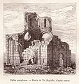 Théophile Deyrolle "Eglise Georgiene".


See also
References
- ^ Revue des Études Arméniennes, volume 2, 1965, page 184
External links
- THE CHURCH OF VARZAHAN at Virtual Ani


- Armenian churches in Turkey
- Oriental Orthodox congregations established in the 12th century
- Christian monasteries established in the 12th century
- Destroyed churches
- Demolished buildings and structures in Turkey
- 12th-century establishments in Asia
- 20th-century disestablishments in Turkey
- Buildings and structures demolished in the 20th century