Don Edwards San Francisco Bay National Wildlife Refuge
| Don Edwards San Francisco Bay National Wildlife Refuge | |
|---|---|
IUCN category IV (habitat/species management area) | |
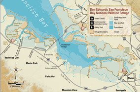
 Map of the DESFBNWR (2003) | |
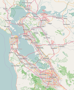
| Location | Alameda County, San Mateo County, Santa Clara County, California, United States |
| Nearest city | Fremont, California |
| Coordinates | 37°30′00″N 122°07′00″W / 37.5°N 122.116667°W[1] |
| Area | 30,000 acres (120 km2) |
| Established | 1974 |
| Governing body | U.S. Fish and Wildlife Service |
| Website | www |
Don Edwards San Francisco Bay National Wildlife Refuge (DESFBNWR) is a United States National Wildlife Refuge located in the southern part of San Francisco Bay, California. The Refuge headquarters and visitor center is located in the Baylands district of Fremont, next to Coyote Hills Regional Park, in Alameda County. The visitor center is on Marshlands Rd, off Thornton Ave.[2]
Most of the refuge stretches along the marshy shoreline north and south of the Dumbarton Bridge, but Bair Island, in San Mateo County, is also part of the system. The southernmost extent of the refuge is in northern Santa Clara County.
History
It was founded in 1974 as the first urban National Wildlife Refuge established in the United States, and it is dedicated to preserving and enhancing wildlife habitat, protecting migratory birds, protecting threatened and endangered species, and providing opportunities for wildlife-oriented recreation and nature study for the surrounding communities.
As of 2004, the Refuge spanned 30,000 acres (120 km2) of open bay, salt pond, salt marsh, mudflat, upland and vernal pool habitats located throughout south San Francisco Bay. About 9,000 acres (36 km2) of salt ponds within the refuge are managed by Cargill Salt, which has perpetual salt-making rights. Cargill uses the salt ponds to concentrate brines as part of its solar salt operation which produces salt for food, agriculture, medical, and industrial uses throughout the Western United States.
Located along the Pacific Flyway, the Refuge hosts over 280 species of birds each year. The variety of birds that may call the refuge home or as a stopover consist of the white pelicans, kites, hawks, ospreys, and eagles. Millions of shorebirds and waterfowl stop to refuel at the Refuge during the spring and fall migration. In addition to its seasonal visitors, the Refuge provides critical habitat to resident species like the endangered California clapper rail and salt marsh harvest mouse. Today, hundreds of thousands of people visit the Refuge each year to enjoy its diverse wildlife and habitats.
The Don Edwards San Francisco Bay National Wildlife Refuge is one of six wildlife refuges in the San Francisco Bay Area. The others are: Antioch Dunes, Ellicott Slough, Farallon, Marin Islands, and San Pablo Bay. It was renamed Don Edwards San Francisco Bay National Wildlife Refuge in 1995 in recognition of Congressman Don Edwards and his efforts to protect sensitive wetlands in south San Francisco Bay.
Gallery
|
See also
References
- ^ "Don Edwards San Francisco Bay National Wildlife Refuge". Geographic Names Information System. United States Geological Survey, United States Department of the Interior. 15 November 2011. Retrieved 29 December 2016.
- ^ "Refuge pamphlet with map" (PDF). 23 August 2013. Archived from the original (PDF) on August 23, 2013. Retrieved 19 January 2016.
{{cite web}}: Unknown parameter|deadurl=ignored (|url-status=suggested) (help)
![]() This article incorporates public domain material from websites or documents of the United States Fish and Wildlife Service.
This article incorporates public domain material from websites or documents of the United States Fish and Wildlife Service.
External links
- US HR Law 92-330
- Large collection of photos and trail descriptions of Don Edwards Wildlife Refuge
- Don Edwards San Francisco Bay National Wildlife Refuge – US Fish and Wildlife Service official site.
- Don Edwards San Francisco Bay National Wildlife Refuge: Final Comprehensive Conservation Plan US Fish and Wildlife Service
- San Francisco Bay National Wildlife Refuge Complex
- South Bay Salt Pond Restoration Project
- Cargill Salt – San Francisco Bay
- From Salt Ponds to Wetlands, Quest, KQED-TV.
- YouTube footage
- IUCN Category IV
- Don Edwards San Francisco Bay National Wildlife Refuge
- Wetlands of California
- Wetlands of the San Francisco Bay Area
- National Wildlife Refuges in California
- Protected areas of Alameda County, California
- Protected areas of San Mateo County, California
- Protected areas of Santa Clara County, California
- Protected areas established in 1974
- San Francisco Bay
- Tourist attractions in Fremont, California
- Landforms of Alameda County, California
- Landforms of San Mateo County, California
- Landforms of Santa Clara County, California
- San Francisco Bay Trail


