Paris metropolitan area: Difference between revisions
No edit summary |
wait, the first 'administrative' is actually needed to differentiate its borders from those of the non-administrative INSEE statistical zone. |
||
| (4 intermediate revisions by the same user not shown) | |||
| Line 4: | Line 4: | ||
[[File:Paris and vicinities, LandSat-5 false color satellite image, 2006-07-16.jpg|thumb|250px|right|Satellite image of the Parisian metropolitan area]] |
[[File:Paris and vicinities, LandSat-5 false color satellite image, 2006-07-16.jpg|thumb|250px|right|Satellite image of the Parisian metropolitan area]] |
||
The '''[[Paris]] [[aire urbaine]]''' (or "[[ |
The '''[[Paris]] [[aire urbaine]]''' (or "[[urban area]]") is a statistical area that describes the reach of commuter movement to and from Paris and its surrounding suburbs. Created by France's [[INSEE]] economy and census institution to describe suburban development around centres of urban growth, the ''aire urbaine'' is composed of a ''couronne (périurbaine)'' (or "rim") surrounding a more densely-constructed and densely-populated ''[[unité urbaine]]'' (or "urban cluster"). As of 2009 the [[Paris]] ''aire urbaine'', with its 14,549 km², extends slightly beyond Paris' administrative [[Île-de-France (region)|Île-de-France]] [[région in France|region]], an area also commonly referred to as the ''Région Parisienne'' ("Paris Region"). |
||
==Overview== |
==Overview== |
||
The Paris ''aire urbaine'' expands at each population census due to the rapid population growth in the Paris area: new [[communes of France|communes]] (municipalities) surrounding Paris |
The Paris ''aire urbaine'' expands at each population census due to the rapid population growth in the Paris area: new [[communes of France|communes]] (municipalities) surrounding Paris are included when they meet the 40% commuter threshold required. At the 1968 census, the earliest date for which population figures were retrospectively computed for French ''aire urbaines'', the Paris ''aire urbaine'' had 9 872 000 inhabitants in an area that only encompassed central Île-de-France. At the 1999 census the Paris ''aire urbaine'' was by then slightly larger than Île-de-France and had 11,174,743 inhabitants. In 2008 its was 12,089,098 million according to [[INSEE]]. |
||
==Demographics== |
==Demographics== |
||
The table below shows the population growth of the ''[[unité urbaine]]'' |
The table below shows the population growth of the Paris ''[[unité urbaine]]'', or Paris and the densely-constructed municipalities surrounding it. (Note: the area shown in red in [[:File:Paris uu ua jms.png|the map]] above): |
||
{| border="3" cellpadding="2" |
{| border="3" cellpadding="2" |
||
|- valign="top" |
|- valign="top" |
||
Revision as of 21:39, 28 August 2013


The Paris aire urbaine (or "urban area") is a statistical area that describes the reach of commuter movement to and from Paris and its surrounding suburbs. Created by France's INSEE economy and census institution to describe suburban development around centres of urban growth, the aire urbaine is composed of a couronne (périurbaine) (or "rim") surrounding a more densely-constructed and densely-populated unité urbaine (or "urban cluster"). As of 2009 the Paris aire urbaine, with its 14,549 km², extends slightly beyond Paris' administrative Île-de-France region, an area also commonly referred to as the Région Parisienne ("Paris Region").
Overview
The Paris aire urbaine expands at each population census due to the rapid population growth in the Paris area: new communes (municipalities) surrounding Paris are included when they meet the 40% commuter threshold required. At the 1968 census, the earliest date for which population figures were retrospectively computed for French aire urbaines, the Paris aire urbaine had 9 872 000 inhabitants in an area that only encompassed central Île-de-France. At the 1999 census the Paris aire urbaine was by then slightly larger than Île-de-France and had 11,174,743 inhabitants. In 2008 its was 12,089,098 million according to INSEE.
Demographics
The table below shows the population growth of the Paris unité urbaine, or Paris and the densely-constructed municipalities surrounding it. (Note: the area shown in red in the map above):
|
|
|
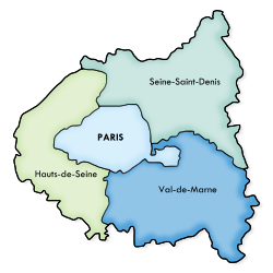
Petite Couronne


The Petite Couronne[1] (Little Crown, i.e. Inner Ring) is the hub of the urban agglomeration of Paris. It is formed by the 3 departments of Île-de-France bordering with the French capital and forming a geographical crown around it. The departments, until 1968 part of the disbanded Seine department, are Hauts-de-Seine, Seine-Saint-Denis and Val-de-Marne. The most populated towns of the Petite Couronne are Boulogne-Billancourt, Montreuil, Saint-Denis, Nanterre and Créteil.
The table below shows some statistical information about the area including Paris:
| Department | Area (km²) | Population | Municipalities |
|---|---|---|---|
| Paris (75) | 105.4
|
2,193,031[2]
|
1 (Paris)
|
| Hauts-de-Seine (92) | 176
|
1,536,100[3]
|
|
| Seine-Saint-Denis (93) | 236
|
1,502,340[3]
|
|
| Val-de-Marne (94) | 245
|
1,298,340[3]
|
|
| Petite Couronne | 657
|
4,336,780
|
123
|
| Paris + Petite Couronne | 762.4
|
6,529,811
|
124
|
According to INSEE in 2005 the GDP of the 3 departments plus Paris totaled 355 billion euros (€54.615 por capita).
Grande Couronne
The Grande Couronne[4] (Greater Crown, i.e. Outer Ring) includes the towns of the metropolitan area part of the other 4 departments of Île-de-France not bordering with Paris. They are Seine-et-Marne (77), Yvelines (78), Essonne (91) and Val-d'Oise (95). The latter three departments formed the Seine-et-Oise department until this was disbanded in 1968. The city of Versailles is part of this area.
See also
References
- ^ Template:Fr icon CIG "Petite Couronne" website (Centre Interdépartemental de Gestion)
- ^ Template:Fr icon INSEE. "Commune : Paris (75056) – Thème : Évolution et structure de la population". Retrieved 2010-07-01.
- ^ a b c 2006 estimate
- ^ Template:Fr icon CIG "Grande Couronne" website (Centre Interdépartemental de Gestion)
External links
- Template:Fr icon Document about the functioning of Paris Metropolitan Area
- Template:Fr icon Document about the extension of Paris Metropolitan Area
