
Door County, Wisconsin
Door County | |
|---|---|
 Door County Government Center | |
 Location within the U.S. state of Wisconsin | |
 Wisconsin's location within the U.S. | |
| Coordinates: 45°01′N 87°01′W / 45.02°N 87.01°W | |
| Country | |
| State | |
| Founded | 1861 |
| Named for | Door Peninsula |
| Seat | Sturgeon Bay |
| Largest city | Sturgeon Bay |
| Area | |
| • Total | 2,370 sq mi (6,100 km2) |
| • Land | 482 sq mi (1,250 km2) |
| • Water | 1,888 sq mi (4,890 km2) 80% |
| Population (2010) | |
| • Total | 27,785 |
| • Density | 58/sq mi (22/km2) |
| Time zone | UTC−6 (Central) |
| • Summer (DST) | UTC−5 (CDT) |
| Congressional district | 8th |
| Website | www |
Door County is a county in the U.S. state of Wisconsin. As of the 2010 census, the population was 27,785.[1] Its county seat is Sturgeon Bay.[2]
The county was created in 1851 and organized in 1861.[3] It is named after the strait between the Door Peninsula and Washington Island. The dangerous passage, known as Death's Door, is now scattered with shipwrecks, and was known to early French explorers and local Native Americans.
Door County is a popular vacation and tourist destination, especially for residents of Wisconsin and Illinois.[4]
History
The Door County peninsula has been inhabited for about 11,000 years.[5] Artifacts from an ancient village site at Nicolet Bay Beach have been dated to about 400 BC. This site was occupied by various cultures until about 1300 AD.[6]
Door County's name came from Porte des Morts, anglicized as "Death's Door," or the passage between the tip of the Door County Peninsula and Washington Island.[7] It is a common misconception that the name "Death's Door," or "Porte des Morts", arose from the number of shipwrecks associated with the passage. It was instead the result of Native American tales, heard by early French explorers and greatly embellished by Hjalmar Holand that related to a failed raid by the Ho-Chunk (Winnebago) tribe to capture Washington Island from the rival Pottawatomie tribe in the early 1600s.[8]
Prior to and during the 19th century, various groups of Native Americans occupied the area that would become Door County and its islands. 17th century French explorers made contact with various tribes, including Potawatomi living in the Door Peninsula, but by the end of the French rule over the area in 1763, the Potawatomi had begun a move to the Detroit area, leaving the large communities in Wisconsin. Later, some Potawatomi moved back from the lower peninsula of Michigan to northern Wisconsin. Some, but not all Potawatomi later left northern Wisconsin and settled into northern Indiana and central Illinois.[9]

The Menominee ceded their claim to the Door Peninsula to the United States in the 1836 Treaty of the Cedars following years of negotiations with the Ho-Chunk and the United States government over how to accommodate the incoming populations of Oneida, Stockbridge-Munsee, and Brothertown peoples who had been removed from New York.[10] At the same time, the more decentralized Potawatomi were divested of their land without compensation. Many emigrated to Canada. Reasons for emigrating included an invitation from other Native Americans already in Canada, favorable treaty arrangements, and a desire to avoid the harsh terms of the 1833 Treaty of Chicago. Although not all Potawatomi participated in the Treaty of Chicago, at the time it was Federal policy that any who did not relocate westwards as the treaty stipulated would not be compensated for their land.[11]
Potawatomi Chief Simon Kahquados traveled to Washington, D.C. multiple times in an attempt to get the land back. In 1906, Congress passed a law to establish a census of all Potawatomi formerly living in Wisconsin and Michigan as a first step towards compensation. The 1907 "Wooster" roll, named after the clerk who compiled it, documented 457 Potawatomi living in Wisconsin and Michigan and 1423 living in Ontario. Instead of returning the land, a meager monthly payment was issued.[11] Although Chief Simon Kahquados was unsuccessful he was able to increase public consciousness of Potawatomi history. In 1931, 15,000 people attended his burial in Peninsula State Park.[12]


The 18th and 19th centuries saw the immigration and settlement of pioneers, mariners, fishermen, loggers, and farmers, with the first white settler being Increase Claflin.[13] In the 19th century, a fairly large-scale immigration of Belgian Walloons populated a small region in southern portion of the county.[6] They built small roadside votive chapels, some still in use today.[14] Eagle Bluff Lighthouse was constructed in Peninsula State Park in 1868 on orders from President Andrew Johnson, at a cost of $12,000. It was restored by the Door County Historical Society in 1964, and opened to the public.[15] When the 1871 Peshtigo Fire burned the town of Williamsonville, 60 people were killed. The area of this disaster is now Tornado Memorial County Park, named for the whirlwinds of fire.[16]
In 1941, the Sturgeon Bay Vocation School opened, now it is the Sturgeon Bay campus of Northeast Wisconsin Technical College. A Civilian Conservation Corps camp was established at Peninsula State Park during the Great Depression. In the summer of 1945, Fish Creek was the site of a POW camp under an affiliation with a base camp at Fort Sheridan, Illinois.[17][18][19] The German prisoners engaged in construction projects, cut wood, and picked cherries in Peninsula State Park and the surrounding area.[20]
Geography

According to the U.S. Census Bureau, the county has a total area of 2,370 square miles (6,100 km2), of which 482 square miles (1,250 km2) is land and 1,888 square miles (4,890 km2) (80%) is water.[21] It is the largest county in Wisconsin by total area. The county also has 298 miles (480,000 m) of shoreline. Locals and tourists alike refer to the area as the "Cape Cod of the Midwest".[22] The county covers the majority of the Door Peninsula. With the completion of the Sturgeon Bay Shipping Canal in 1881, the northern half of the peninsula, technically became an island.[15] The 45th parallel north bisects this "island," and this is commemorated by Meridian County Park.[23]
Limestone outcroppings of the Niagara Escarpment are visible on both shores of the peninsula, but the karst formations are larger and more prominent on the Green Bay side as seen at the Bayshore Blufflands. Progressions of dunes have created much of the rest of the shoreline, especially on the easterly side. Flora along the shore provides clear evidence of plant succession. The middle of the peninsula is mostly flat or rolling cultivated land. The height of the escarpment made it attractive to development. At the time of its completion in 1999, the 30.5 acre (12.3 ha) Rosière Wind Farm was the largest in the Eastern United States.[24]
Soils overlaying the dolomite bedrock are very thin in the northern half of the county; thirty-nine percent of the County is mapped as having less than three feet (about a meter) to bedrock. Beyond the northern tip of the peninsula, the partially submerged ridge forms the Potawatomi Islands, which stretch to the Garden Peninsula in the Upper Peninsula of Michigan. The largest of these islands is Washington Island. Most of these islands form the Town of Washington.[25]
Biota
There are 24 state-defined natural areas in the county.[26] Besides Lake Michigan, there are 25 lakes, ponds or marshes and 37 rivers, creeks, streams, and springs in the county.[27]
Flora
Door County, along with nearby Marinette and Delta (see Garden Peninsula) counties, is home to endemic plants and disjunct populations,[28] such as those protected at Hog and Plum Islands, Coffee Swamp, Cave Point County Park, the adjacent Whitefish Dunes State Park, and The Ridges Sanctuary. 25 native orchid species are found at The Ridges.[29] As of 2019, 1201 species and hybrids of vascular plants[30] and 255 unique taxa of mosses, liverworts, and hornworts[31] have been identified in Door County. In 2006, 60 species of aquatic plants or macrophytic algae were found in Clark Lake and nearby upstream.[32] In 2017, 9 species of aquatic plants were found in the Forestville Millpond, also called the Forestville Dam or Forestville Flowage.[33] The U.S. Potato Genebank just north of Sturgeon Bay is the world's largest living collection of wild and domesticated potatoes.[34] As of 2019, 243 species of mushrooms and other macrofungi have been identified north of the canal,[35] with 326 species for the county as a whole.[36] As of 2019, 243 species of mushrooms and other macrofungi have been identified north of the canal.[37]
Fauna
From 1971 through 1976, 11 species of small mammals were found at Toft Point,[38] the Newport State Park Mammals Checklist has 34 species,[39] and in 1972 44 mammals were listed for the entire county.[40] In 1992, six amphibians and eight reptiles were found in and around Potawatomi State Park.[41] As of 2018, 166 species of birds have been confirmed to live in Door County, excluding birds seen which lack the habitat to nest and must only be passing through.[42] In 1999, the Wisconsin Natural Heritage Inventory listed 24 aquatic and 21 terrestrial animals in Door County as being "rare."[43] In particular, Kangaroo Lake State Natural Area has the largest breeding population of the endangered Hine's Emerald Dragonfly in the world.[44]
Air pollution

Most air pollution in Door County comes outside the county. This map shows how air travels to the pollution monitor in Newport State Park.[45] Because the monitor at Newport State park is near the shore, only the red lines (which show the lower air currents) meaningfully depict the path of ozone to the monitor. Unfortunately, as shown on the map, these lower air currents carry polluted air from major urban areas. But further inland, the air from higher up mixes more, so all color lines are significant when tracing the path of air pollution further inland. Fortunately, these higher air currents (shown in green and blue) blow in from cleaner, mostly rural areas.[46]
Tourism


Hjalmar Holand, an Ephraim resident, promoted Door County as a tourist destination in the first half of the 20th century. Leading a committee to protect and promote historically important sites, a series of county parks were established. Since then the tourism industry has grown. Although Door County has a year-round population of about 28,000, it experiences an influx of tourists each summer between Memorial Day and Labor Day. Most businesses are targeted to tourism and operate seasonally. In the summer, the population of Door County is much larger.[47] The majority of tourists and summer residents come from the metropolitan areas of Milwaukee, Chicago, Madison, Green Bay, and the Twin Cities.[48] The area has been called "the Cape Cod of the Midwest."[48] Tourism supports a Bohemian arts community from Sturgeon Bay northward.
Door County is home to five state parks: Newport State Park, northeast of Ellison Bay; Peninsula State Park, east of Fish Creek; Potawatomi State Park, along Sturgeon Bay; Rock Island State Park, off the tip of the Door Peninsula; and Whitefish Dunes State Park, along Lake Michigan.[49] A local land trust operates 14 privately owned parks open to the public,[50] and thousands of acres of other privately owned land are open to the public for hunting, fishing, hiking, sight-seeing and cross-country skiing under the Managed Forest Program.[51]
Door County has ten lighthouses. Most were built during the 19th century and are listed in the National Register of Historic Places: Baileys Harbor Range Lights; Cana Island Lighthouse; Chambers Island Lighthouse; Eagle Bluff Lighthouse; Pilot Island Lighthouse; Plum Island Range Lights; Pottawatomie Lighthouse; and Sturgeon Bay Canal Lighthouse. The other lighthouses in the county are: Baileys Harbor Lighthouse; Sherwood Point Lighthouse; and the Sturgeon Bay Canal North Pierhead Light.[52]
Door County has a history of cherry and apple growing that dates back to the 19th century.[53] Farmers were encouraged to grow fruit on the basis of the relatively mild climate on the peninsula. This is due to the moderating effects of the lake and bay on nearby land temperatures. U-pick orchards and fruit stands can be found along country roads when in season, and there are two frozen cherry processors.[54] However, the cherry business has declined since peaking in the late 1960s[55] due to lack of migrant labor and a difficulty in finding local help, the closing of a major cannery, unpredictable harvests, and better growing conditions to the east in the fruit belt, such as the nearby Traverse City area.[56]
Scandinavian heritage related attractions include fish boils,[57] The Clearing Folk School, two stave churches,[58] and Al Johnson's Swedish Restaurant, which features goats on its grassy roof.
Door County also has businesses which produce alcoholic beverages,[59] and as a result the county became part of a federally designated wine grape-growing region in 2012. In order to encourage more tourism, Ephraim residents passed referenda in 2016 to allow beer and/or wine sales within the village. Prior to this, Ephraim had been the last dry municipality in the state.[60]
Transportation
Major highways
 Wisconsin Highway 42, subsection on Door County
 Highway 57 (Wisconsin)
- Door County Coastal Byway (WIS 42 and 57 north of Sturgeon Bay to Northport is classified as a Coastal Byway)
Airports
- Door County Cherryland Airport (KSUE), located three miles west of Sturgeon Bay, Wisconsin
- Ephraim–Gibraltar Airport (3D2), located one mile southwest of Ephraim, Wisconsin
- Washington Island Airport (2P2), enhances local service.
Ferries
- Washington Island is served by two ferry routes. The first route is to take a 30-minute ferry ride from the Door Peninsula to Detroit Harbor on the island from a freight, automobile, and passenger ferry that departs daily from the Northport Pier at the northern terminus of Wisconsin Highway 42. The second route is a passenger-only ferry that departs from the unincorporated community of Gills Rock on a 20-minute route.[61]
- Rock Island State Park is reachable by the passenger ferry Karfi from Washington Island.[62] (During winter Rock Island is also accessible via snowmobile and foot traffic.)
Bridges across the bay

- Sturgeon Bay Bridge, (also called Michigan Street Bridge) (11.5 feet clearance)
- Oregon Street Bridge
- Bayview Bridge
Non-motorized
- The Ahnapee State Trail connects Sturgeon Bay to Kewaunee, winter snowmobile access is dependent on weather and trail grooming.[63]
Demographics
This section needs additional citations for verification. (January 2019) |
| Census | Pop. | Note | %± |
|---|---|---|---|
| 1860 | 2,948 | — | |
| 1870 | 4,919 | 66.9% | |
| 1880 | 11,645 | 136.7% | |
| 1890 | 15,082 | 29.5% | |
| 1900 | 17,583 | 16.6% | |
| 1910 | 18,711 | 6.4% | |
| 1920 | 19,073 | 1.9% | |
| 1930 | 18,182 | −4.7% | |
| 1940 | 19,095 | 5.0% | |
| 1950 | 20,870 | 9.3% | |
| 1960 | 20,685 | −0.9% | |
| 1970 | 20,106 | −2.8% | |
| 1980 | 25,029 | 24.5% | |
| 1990 | 25,690 | 2.6% | |
| 2000 | 27,961 | 8.8% | |
| 2010 | 27,785 | −0.6% | |
| 2016 (est.) | 27,587 | [64] | −0.7% |
| U.S. Decennial Census[65] 1790–1960[66] 1900–1990[67] 1990–2000[68] 2010–2014[1] | |||

As of the census of 2000,[69] there were 27,961 people, 11,828 households, and 7,995 families residing in the county. The population density was 58 people per square mile (22/km²). There were 19,587 housing units at an average density of 41 per square mile (16/km²). The racial makeup of the county was 97.84% White, 0.19% Black or African American, 0.65% Native American, 0.29% Asian, 0.01% Pacific Islander, 0.33% from other races, and 0.69% from two or more races. 0.95% of the population were Hispanic or Latino of any race. 39.4% were of German and 10.3% Belgian ancestry. A small pocket of Walloon speakers forms the only Walloon-language region outside of Wallonia and its immediate neighbors.[70] Out of a total of 11,828 households, 26.90% had children under the age of 18 living with them, 58.10% were married couples living together, 6.50% had a female householder with no husband present, and 32.40% were non-families. 28.10% of all households were made up of individuals and 12.70% had someone living alone who was 65 years of age or older. The average household size was 2.33 and the average family size was 2.84.[citation needed]
In the county, the population was spread out with 22.10% under the age of 18, 6.10% from 18 to 24, 25.40% from 25 to 44, 27.70% from 45 to 64, and 18.70% who were 65 years of age or older. The median age was 43 years. For every 100 females there were 97.10 males. For every 100 females age 18 and over, there were 94.50 males.[citation needed]
Communities
City
- Sturgeon Bay (county seat)
Villages
Towns
- Baileys Harbor (Cana Island is in Town of Baileys Harbor)
- Brussels
- Clay Banks
- Egg Harbor (was hit by an F3 tornado in 1998)
- Forestville
- Gardner
- Gibraltar (the Strawberry Islands, Hat, Horseshoe, and Chambers Island are in the Town of Gibraltar)
- Jacksonport
- Liberty Grove (Gravel Island, Spider Island, and the Sister Islands are in the Town of Liberty Grove)
- Nasewaupee
- Sevastopol
- Sturgeon Bay
- Union
- Washington Island
Census-designated places
Unincorporated communities
- Brussels
- Carlsville
- Carnot
- Detroit Harbor
- Fish Creek
- Gills Rock
- Idlewild
- Institute
- Jacksonport
- Juddville
- Kolberg
- Maplewood
- Namur
- North Bay
- Northport
- Peninsula Center
- Rosiere (partial)
- Rowleys Bay
- Salona
- Shoemaker Point
- Valmy
- Vignes
- Washington
- West Jacksonport
- Whitefish Bay
Adjacent counties
- Kewaunee County - South
- Brown County - Southwest
- Oconto County - West
- Marinette County - Northwest
- Menominee County, Michigan - Northwest
- Delta County, Michigan - North
Politics
Door County has voted for the winning candidate in every presidential election since 1996.
| Year | Republican | Democratic | Third parties |
|---|---|---|---|
| 2016 | 48.8% 8,580 | 45.6% 8,014 | 5.7% 998 |
| 2012 | 46.0% 8,121 | 53.0% 9,357 | 1.1% 193 |
| 2008 | 40.7% 7,112 | 58.0% 10,142 | 1.3% 227 |
| 2004 | 50.9% 8,910 | 47.8% 8,367 | 1.2% 214 |
| 2000 | 51.3% 7,810 | 43.1% 6,560 | 5.6% 850 |
| 1996 | 40.4% 4,948 | 45.6% 5,590 | 14.0% 1,713 |
| 1992 | 39.7% 5,468 | 34.4% 4,735 | 25.9% 3,574 |
| 1988 | 55.6% 6,907 | 43.7% 5,425 | 0.7% 90 |
| 1984 | 67.4% 8,264 | 31.9% 3,916 | 0.7% 91 |
| 1980 | 55.2% 7,170 | 38.2% 4,961 | 6.6% 851 |
| 1976 | 57.4% 6,557 | 39.9% 4,553 | 2.7% 307 |
| 1972 | 64.3% 6,503 | 33.9% 3,430 | 1.9% 188 |
| 1968 | 63.3% 5,647 | 30.6% 2,728 | 6.1% 541 |
| 1964 | 49.2% 4,289 | 50.7% 4,416 | 0.1% 9 |
| 1960 | 61.5% 5,790 | 38.4% 3,610 | 0.2% 14 |
| 1956 | 78.0% 6,722 | 21.6% 1,859 | 0.5% 41 |
| 1952 | 80.8% 7,621 | 19.0% 1,790 | 0.2% 19 |
| 1948 | 65.8% 4,911 | 32.7% 2,440 | 1.5% 108 |
| 1944 | 68.3% 5,668 | 31.3% 2,599 | 0.5% 38 |
| 1940 | 66.1% 5,461 | 33.3% 2,750 | 0.6% 49 |
| 1936 | 41.1% 3,146 | 51.6% 3,952 | 7.4% 566 |
| 1932 | 37.0% 2,488 | 61.6% 4,149 | 1.4% 97 |
| 1928 | 59.3% 3,636 | 40.0% 2,456 | 0.7% 42 |
| 1924 | 38.6% 1,891 | 4.8% 235 | 56.6% 2,778 |
| 1920 | 88.3% 3,817 | 8.9% 385 | 2.8% 119 |
| 1916 | 56.3% 1,656 | 40.9% 1,204 | 2.9% 84 |
| 1912 | 41.2% 1,167 | 27.1% 769 | 31.7% 900 |
| 1908 | 73.9% 2,463 | 23.3% 778 | 2.8% 93 |
| 1904 | 80.5% 2,689 | 15.4% 515 | 4.1% 136 |
| 1900 | 76.3% 2,362 | 21.8% 674 | 1.9% 60 |
| 1896 | 71.3% 2,402 | 26.6% 895 | 2.1% 72 |
| 1892 | 58.2% 1,596 | 36.7% 1,007 | 5.1% 140 |
Gallery
-
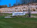 Door County Sign on Highway 57
 -
 Horseshoe Island
 -
 Rosière Wind Farm
 -
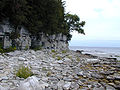
 Outcroppings at Newport State Park approximately 10 feet (3 m) from Lake Michigan
 -
 Cave Point County Park
 -
 Europe Bay Woods State Natural Area
 -
 Door Bluff County Park
 -
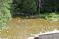 The Ahnapee River below the dam at Forestville
 -
 Sturgeon Bay Shipping Canal
 -
 Door County Fairgrounds
 -
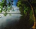
 Mink River Estuary

.jpg)


See also
References
- ^ a b "State & County QuickFacts". United States Census Bureau. Archived from the original on July 9, 2011. Retrieved January 18, 2014.
{{cite web}}: Unknown parameter|deadurl=ignored (|url-status=suggested) (help) - ^ "Find a County". National Association of Counties. Archived from the original on 2011-05-31. Retrieved 2011-06-07.
{{cite web}}: Unknown parameter|deadurl=ignored (|url-status=suggested) (help) - ^ "Wisconsin: Individual County Chronologies". Wisconsin Atlas of Historical County Boundaries. The Newberry Library. 2007. Retrieved August 13, 2015.
- ^ Rebecca L. Schewe; Donald R. Field; Deborah J. Frosch; Gregory Clendenning; Dana Jensen (15 May 2012). Condos in the Woods: The Growth of Seasonal and Retirement Homes in Northern Wisconsin. University of Wisconsin Pres. pp. 22–. ISBN 978-0-299-28533-3.
- ^ Long, C.A. (2008). The Wild Mammals of Wisconsin. Pensoft Series Faunistica. Coronet Books Incorporated. p. 25. ISBN 978-954-642-313-9. Retrieved 2017-04-23.
- ^ a b Soucek, G. (2011). Door County Tales: Shipwrecks, Cherries and Goats on the Roof. American Chronicles. Arcadia Publishing Incorporated. ISBN 978-1-61423-383-1. Retrieved 2017-04-23.
- ^ Gannett, Henry (1905). The Origin of Certain Place Names in the United States. Washington, D.C.: U.S. Government Printing Office. Retrieved May 7, 2018 – via Google Books.
- ^ Kohl, Cris & Joan Forsberg, Shipwrecks at Death's Door, Page 10.
- ^ Edmunds, R. David (1988). The Potawatomis: Keepers of the Fire. Norman, OK: University of Oklahoma Press (Civilization of the American Indian Series); ISBN 0-8061-2069-X
- ^ "Menominee Treaties and Treaty Rights". Indian Country Wisconsin. Retrieved 2018-10-05.
{{cite web}}: Cite has empty unknown parameter:|dead-url=(help) - ^ a b "Potawatomi Migration from Wisconsin & Michigan to Canada". Geni. Retrieved 2019-01-23.
{{cite web}}: Cite has empty unknown parameter:|dead-url=(help) - ^ "Kahquados, Chief Simon". Wisconsin Hometown Stories: Door County. Wisconsin Public Television. Retrieved 22 January 2019.
- ^ Hjalmar Holand. History of Door County Wisconsin, The County Beautiful. Chicago: S. J. Clarke, 1917, p. 77.
- ^ Lott, Katie (1 May 2009). "Southern Door County's Belgian Wayside Chapels". Door County Living. Retrieved 22 January 2019.
{{cite news}}: Unknown parameter|deadurl=ignored (|url-status=suggested) (help)doorcounty.com. "Where to Find Belgian Chapels in Door County". Door County Visitor Bureau. Retrieved 22 January 2019.{{cite web}}: Unknown parameter|deadurl=ignored (|url-status=suggested) (help), also Wisconsin Belgian Roadside Chapels in Google Maps - ^ a b Wardius, K.; Wardius, B. (2013). Wisconsin Lighthouses: A Photographic and Historical Guide, Revised Edition. Wisconsin Historical Society Press. pp. 100–25. ISBN 978-0-87020-610-8. Retrieved 2017-04-23.
- ^ Skiba, Justin (2 September 2016). "The Fire That Took Williamsonville". Door County Living. Retrieved 22 January 2019.
{{cite news}}: Unknown parameter|deadurl=ignored (|url-status=suggested) (help) - ^ Mariah Goode. "The Harvest of 1945: German POW Camps Filled Door County’s Labor Shortage". Door County Pulse, July 1, 2005.
- ^ cheyenne Lentz. "Story Of Wisconsin's German POWs Is A Piece Of Hidden History, Author Says". Wisconsin Public Radio, June 23, 2015.
- ^ Damien Jaques. "Cherry picking with German POWs in Door County". On Milwaukee, July 9, 2012.
- ^ Tishler, W.H. (2006). Door County's Emerald Treasure: A History of Peninsula State Park. Wisconsin Land and Life. University of Wisconsin Press. ISBN 978-0-299-22073-0. Retrieved 2017-04-23.
- ^ "2010 Census Gazetteer Files". United States Census Bureau. August 22, 2012. Archived from the original on September 4, 2015. Retrieved 2015-08-04.
{{cite web}}: Unknown parameter|deadurl=ignored (|url-status=suggested) (help) - ^ Lyttle, Bethany (September 11, 2008). "The Cape Cod of the Midwest". New York Times. Retrieved 23 April 2017.
- ^ "Meridian County Park". Door County Parks. Retrieved 2019-01-22.
{{cite web}}: Unknown parameter|deadurl=ignored (|url-status=suggested) (help) - ^ "Rosière Wind Farm". Madison Gas and Electric. Retrieved 2009-07-08. and "MGE Celebrates 10th Anniversary of State's First Wind Farm". Wisconsin Ag Connection. 2009-07-07. Retrieved 2009-07-08.
- ^ "Soil Survey of Door County, Wisconsin" (PDF). USDA SCS. December 1978. Retrieved 2019-01-22.
{{cite web}}: Unknown parameter|deadurl=ignored (|url-status=suggested) (help) - ^ Wisconsin DNR. "Door". State natural areas by county. Retrieved 22 January 2019.
{{cite web}}: Unknown parameter|deadurl=ignored (|url-status=suggested) (help) - ^ Wisconsin DNR (27 November 2009). "Page 20 of the pdf, Tables 4.15 and 4.16" (PDF). Door County Comprehensive Plan 2030: Chapter 4, Agricultural and Natural Resources. Retrieved 22 January 2019.
{{cite web}}: Unknown parameter|deadurl=ignored (|url-status=suggested) (help) - ^ Emmet Judziewicz and David Kopitzke (September 1999). "Wisconsin's Lake Michigan Islands Plant Survey-II" (PDF). Wisconsin Department of Natural Resources, Bureau of Endangered Resources. Retrieved 23 January 2019.
{{cite web}}: Unknown parameter|deadurl=ignored (|url-status=suggested) (help) - ^ Jones, Meg (September 17, 2013). "Rare native orchids in Door County get a helping hand". Jsonline. Retrieved 22 January 2019.
- ^ Wisflora Species list
- ^ Mycology Collections Portal. "Consortium of North American Bryophyte Herbaria". (CNABH). Retrieved 24 January 2019.
{{cite web}}: Unknown parameter|deadurl=ignored (|url-status=suggested) (help) - ^ Darrin Hoverson and Nancy Turyk (November 2006). "2006 Summary and Comparisons of Clark Lake - Door County Aquatic Macrophyte Community Surveys" (PDF). University of Wisconsin, Stevens Point Center for Watershed Science and Education. Retrieved 22 January 2019.
{{cite web}}: Unknown parameter|deadurl=ignored (|url-status=suggested) (help) - ^ Door County Soil and Water Conservation Department (June 2018). "7. Aquatic Plant Inventory, page 41" (PDF). Final Report for Comprehensive Lake Management Planning Grant Project #LPL162317 Forestville Millpond. Retrieved 22 January 2019.
{{cite web}}: Unknown parameter|deadurl=ignored (|url-status=suggested) (help) - ^ Jones, Gary (September 16, 2009). "Door County's Potato Genebank". Door County Pulse. Retrieved 22 January 2019., also see NRSP6: The US Potato Genebank: Acquisition, Classification, Preservation, Evaluation and Distribution of Potato (Solanum) Germplasm
- ^ Charlotte Lukes. "Biodiversity of Macrofungi in Northern Door County, WI". UWGB Cofrin Center for Biodiversity. Retrieved 22 January 2019.
{{cite web}}: Unknown parameter|deadurl=ignored (|url-status=suggested) (help) - ^ Mycology Collections Portal. "Search for Door, Wisconsin". Mycoportal. Retrieved 24 January 2019.
{{cite web}}: Unknown parameter|deadurl=ignored (|url-status=suggested) (help) - ^ Charlotte Lukes. "Biodiversity of Macrofungi in Northern Door County, WI". UWGB Cofrin Center for Biodiversity. Retrieved 22 January 2019.
{{cite web}}: Unknown parameter|deadurl=ignored (|url-status=suggested) (help) - ^ Johnson, Wendel J. (1978). "Small mammals of the Toft Point scientific area, Door County, Wisconsin: a preliminary survey". The State of Wisconsin Collection. Retrieved 6 February 2019.
{{cite web}}: Unknown parameter|deadurl=ignored (|url-status=suggested) (help) - ^ Melinda Kleinedler (March 2017). "Newport State Park Mammals Checklist" (PDF). Newport Wilderness Society. Retrieved 22 January 2019.
{{cite web}}: Unknown parameter|deadurl=ignored (|url-status=suggested) (help) - ^ Col. James M. Miller (October 1974). "Draft Environmental Statement for the Sturgeon Bay and Lake Michigan Canal, Wisconsin". U.S. Army Corps of Engineers. Retrieved 6 February 2019.
{{cite web}}: Unknown parameter|deadurl=ignored (|url-status=suggested) (help) - ^ Dreux J. Watermolen (December 1992). "page 6 of the pdf, Amphibians and Reptiles of the Potawatomi State Park Area with Notes on Other Door County Localities" (PDF). Chicago Herpetological Society. Retrieved 22 January 2019.
{{cite web}}: Unknown parameter|deadurl=ignored (|url-status=suggested) (help) - ^ Nick Anich (2 October 2018). "Season 4 Preliminary Results and Stats". UWGB Cofrin Center for Biodiversity. Retrieved 22 January 2019.
{{cite web}}: Unknown parameter|deadurl=ignored (|url-status=suggested) (help) and ebird.org. "Wisconsin Breeding Bird Atlas". Cornell Lab of Ornithology. Retrieved 22 January 2019.{{cite web}}: Unknown parameter|deadurl=ignored (|url-status=suggested) (help) - ^ Door County Soil and Water Conservation Department (27 June 1999). "Figure 11 General Distribution of Rare Species and Habitats in Door County, page 62 of the pdf" (PDF). Surface Water Inventory of Door County. Retrieved 22 January 2019.
{{cite web}}: Unknown parameter|deadurl=ignored (|url-status=suggested) (help) - ^ "Hines Dragonfly". Hinesdragonfly.org. Archived from the original on 2007-09-28. Retrieved 2007-08-03.
{{cite web}}: Unknown parameter|deadurl=ignored (|url-status=suggested) (help) - ^ Photo of the monitoring station on page 128 of WI DNR. "Air Monitoring Network Plan 2016 June 2015" (PDF). EPA. Retrieved 6 February 2019.
{{cite web}}: Unknown parameter|deadurl=ignored (|url-status=suggested) (help) - ^ US EPA. "Wisconsin: Northern Milwaukee/Ozaukee Shoreline Area, Sheboygan County Area, Manitowoc County Area, Door County Area Final Area Designations for the 2015 Ozone National Ambient Air Quality Standards Technical Support Document (TSD)" (PDF). Green Book. Retrieved 7 February 2019.
{{cite web}}: Unknown parameter|deadurl=ignored (|url-status=suggested) (help) - ^ Estimating the Seasonal Population of Door County by Greg Lamb, Door County University Extension]
- ^ a b Lyttle, Bethany (2008-09-11). "'The Cape Cod of the Midwest'". The New York Times. Archived from the original on 2017-10-22. Retrieved 2008-09-25.
{{cite news}}: Unknown parameter|deadurl=ignored (|url-status=suggested) (help) - ^ Five State Parks in Door County Archived 2018-03-31 at the Wayback Machine. Travel Wisconsin, Wisconsin Department of Tourism.
- ^ "Explore Our Preserves". Archived from the original on 2019-01-03. Retrieved 2019-01-22.
{{cite web}}:|archive-date=/|archive-url=timestamp mismatch; 2018-04-10 suggested (help); Unknown parameter|deadurl=ignored (|url-status=suggested) (help) - ^ Lands enrolled in the tax program are shown on the DNR Private Forest Lands Open for Public Recreation interactive map.
- ^ More Door County Lighthouses Archived 2018-05-07 at the Wayback Machine. Door County Maritime Museum.
- ^ Apple & Cherry Orchards: Door County Wisconsin Archived October 6, 2008, at the Wayback Machine
- ^ "Archived copy". Archived from the original on 2014-12-07. Retrieved 2014-12-04.
{{cite web}}: Unknown parameter|deadurl=ignored (|url-status=suggested) (help)CS1 maint: archived copy as title (link) - ^ Mariah Goode (1 September 2008). "Agriculture in Door County". Door County Living. Retrieved 22 January 2018.
{{cite web}}: Unknown parameter|deadurl=ignored (|url-status=suggested) (help) - ^ Jay Jones (April 1, 2015). "Cherries are always in season for Door County". Chicago Tribune. Retrieved 22 January 2018.
{{cite web}}: Unknown parameter|deadurl=ignored (|url-status=suggested) (help) - ^ Joy Marquardt. "Fish boils serve up food, fun". Wausau Daily Herald, August 31, 2016.
- ^ The Björklunden stave church is called Boynton Chapel and it is just south of Baileys Harbor, and the other is both part of and adjacent to Trinity Lutheran Church on Washington Island.
- ^ "Door County Wine Trail". Door County Visitor Bureau. Retrieved May 7, 2018. and "Archived copy". Archived from the original on 2014-12-09. Retrieved 2014-12-04.
{{cite web}}: Unknown parameter|deadurl=ignored (|url-status=suggested) (help)CS1 maint: archived copy as title (link) and "About Us - Island Orchard Cider". islandorchardcider.com. Archived from the original on 22 October 2017. Retrieved 7 May 2018.{{cite web}}: Unknown parameter|deadurl=ignored (|url-status=suggested) (help) - ^ Roberts, Rhonda (6 April 2016). "After 163 years, Door County's Ephraim no longer dry". WBAY-TV, Green Bay. Archived from the original on 18 April 2016. Retrieved 6 April 2016.
{{cite news}}: Unknown parameter|deadurl=ignored (|url-status=suggested) (help) - ^ "The Island Clipper & The Viking Train". www.islandclipper.com. Retrieved 2018-06-26.
- ^ "Rock Island Ferry". www.wisferry.com. Retrieved 2018-07-03.
- ^ Wisconsin Snow Report
- ^ "Population and Housing Unit Estimates". Archived from the original on May 29, 2017. Retrieved June 9, 2017.
{{cite web}}: Unknown parameter|deadurl=ignored (|url-status=suggested) (help) - ^ "U.S. Decennial Census". United States Census Bureau. Archived from the original on 2015-05-12. Retrieved 2015-08-04.
{{cite web}}: Unknown parameter|deadurl=ignored (|url-status=suggested) (help) - ^ "Historical Census Browser". University of Virginia Library. Archived from the original on August 16, 2012. Retrieved August 4, 2015.
{{cite web}}: Unknown parameter|deadurl=ignored (|url-status=suggested) (help) - ^ Forstall, Richard L., ed. (March 27, 1995). "Population of Counties by Decennial Census: 1900 to 1990". United States Census Bureau. Archived from the original on July 18, 2015. Retrieved August 4, 2015.
{{cite web}}: Unknown parameter|deadurl=ignored (|url-status=suggested) (help) - ^ "Census 2000 PHC-T-4. Ranking Tables for Counties: 1990 and 2000" (PDF). United States Census Bureau. April 2, 2001. Archived from the original (PDF) on December 18, 2014. Retrieved 2015-08-04.
{{cite web}}: Unknown parameter|deadurl=ignored (|url-status=suggested) (help) - ^ "American FactFinder". United States Census Bureau. Archived from the original on 2013-09-11. Retrieved 2011-05-14.
{{cite web}}: Unknown parameter|deadurl=ignored (|url-status=suggested) (help) - ^ "Belgian-American Research Collection" Archived 2011-01-06 at the Wayback Machine, University of Wisconsin
- ^ Leip, David. "Dave Leip's Atlas of U.S. Presidential Elections". uselectionatlas.org. Archived from the original on 23 March 2018. Retrieved 7 May 2018.
{{cite web}}: Unknown parameter|deadurl=ignored (|url-status=suggested) (help)
Further reading
- Holand, Hjalmar R. History of Door County, Wisconsin, The County Beautiful. Chicago: S. J. Clarke, 1917.
- Martin, Chas. I. History of Door County, Wisconsin. Sturgeon Bay, Wis.: Expositor Job Print, 1881.
External links
 Door County travel guide from Wikivoyage
- Door County government website
- Door County map from the Wisconsin Department of Transportation
- Door County Historical Society
- Door County Visitor Bureau
- Road Trip to Door County Video produced by Wisconsin Public Television
Places adjacent to Door County, Wisconsin | ||||||||||||||||
|---|---|---|---|---|---|---|---|---|---|---|---|---|---|---|---|---|
| ||||||||||||||||
Municipalities and communities of Door County, Wisconsin, United States | ||
|---|---|---|
| City |  | |
| Villages | ||
| Towns | ||
| CDPs | ||
| Other communities | ||
| Footnote | ‡Partially located in Kewaunee County | |