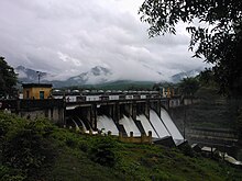
Mangalam Dam
This is an old revision of this page, as edited by Roland zh (talk | contribs) at 17:55, 14 June 2016 (added Category:Buildings and structures in Palakkad district using HotCat). The present address (URL) is a permanent link to this revision, which may differ significantly from the current revision.
This article does not cite any sources. Please help improve this article by adding citations to reliable sources. Unsourced material may be challenged and removed. Find sources: "Mangalam Dam" – news · newspapers · books · scholar · JSTOR (November 2009) (Learn how and when to remove this message) |
Mangalam dam is constructed across the river Cherukunnapuzha which is a tributary of Mangalam river. A canal system for irrigation purpose was completed and opened in 1966, in the Alathur taluk of Palakkad district in Kerala, South India.

Most of the inhabitants come from, Perumbavoor Kottayam or Chalakkudy. There are rubber, pepper, coffee, and tapioca plantations in the area.
Mangalam dam is 16 km away from Vadakkencherry. Odenthode, Kunjiarpathy, Kavilupara, Vattapara, Neethipuram, Ponkandam, Kadappara, Uppumanne, Olipara, Balaswaram-V.R.T and Choorupara are also in the area.
A big landslide occurred in Kavilupara near to Odenthode during the 2007 floods.You can also see thick forest in the area of Karimkayam, Odenthode, Kadappara.
10°30′33″N 76°32′06″E / 10.50917°N 76.53500°E / 10.50917; 76.53500
This article about a dam, floodgate or canal in India is a stub. You can help Wikipedia by expanding it. |

