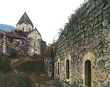
Yerits Mankants Monastery
Appearance
| Yerits Mankants Monastery | |
|---|---|
Երից Մանկանց Վանք | |
 | |
| Religion | |
| Affiliation | Armenian Apostolic Church |
| Location | |
| Location | Martakert Province, Nagorno-Karabakh Republic (de facto); Azerbaijan (de jure) |
| Lua error in Module:Location_map at line 526: Unable to find the specified location map definition: "Module:Location map/data/Nagorno-Karabakh Republic" does not exist. | |
| Geographic coordinates | 40°15′08″N 46°38′26″E / 40.252114°N 46.640669°E |
| Architecture | |
| Style | Armenian |
| Completed | 1691 |
Yerits Mankants Monastery (Armenian: Երից Մանկանց Վանք) is a 17th-century Armenian monastery in the Martakert Province of the Nagorno-Karabakh Republic. It is the most notable example of monasteries built during the late Middle Ages in Artsakh, after an interruption in church building from the 14th to 16th centuries. Yerits Mankants monastery was built around 1691 in the historical county of Jraberd. The monastery was established by the feudal family of Melik-Israelians, Lords of Jraberd, with an apparent purpose to rival the Holy See of Gandzasar and its hereditary patrons the Hasan-Jalalians, Lords of Khachen.


