Dubois County, Indiana: Difference between revisions
No edit summary |
No edit summary |
||
| Line 96: | Line 96: | ||
== Cities and towns == |
== Cities and towns == |
||
===Incorporated=== |
===Incorporated=== |
||
*[[Birdseye, Indiana|Birdseye]] [[Town]] |
*[[Birdseye, Indiana|Birdseye]] ([[Town]]) |
||
*[[Ferdinand, Indiana|Ferdinand]] [[Town]] |
*[[Ferdinand, Indiana|Ferdinand]] ([[Town]]) |
||
*[[Holland, Indiana|Holland]] [[Town]] |
*[[Holland, Indiana|Holland]] ([[Town]]) |
||
*[[Huntingburg, Indiana|Huntingburg]] [[City]] |
*[[Huntingburg, Indiana|Huntingburg]] ([[City]]) |
||
*[[Jasper, Indiana|Jasper]] [[City]] |
*[[Jasper, Indiana|Jasper]] ([[City]]) |
||
===Unincorporated=== |
===Unincorporated=== |
||
| Line 156: | Line 156: | ||
==Recreation== |
==Recreation== |
||
[[Patoka Lake]] is located along the county's eastern borders with both [[Crawford County, IN|Crawford]] and [[Orange County, IN|Orange]] Counties. Patoka lake is home to several annual national tournaments. |
[[Patoka Lake]] is located along the county's eastern borders with both [[Crawford County, IN|Crawford]] and [[Orange County, IN|Orange]] Counties. Patoka lake is home to several annual national tournaments. |
||
==External Links== |
|||
Dubois County Website |
|||
[http://www.duboiscountyin.org/ |
|||
==References== |
==References== |
||
Revision as of 14:06, 11 April 2008
Dubois County | |
|---|---|
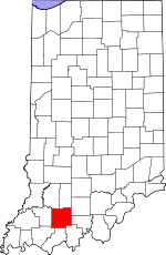
 Location within the U.S. state of Indiana | |
 Indiana's location within the U.S. | |
| Coordinates: 38°22′N 86°53′W / 38.36°N 86.88°W | |
| Country | |
| State | |
| Founded | 1818 |
| Named for | Toussaint Dubois |
| Seat | Jasper |
| Area | |
| • Total | 435 sq mi (1,127 km2) |
| • Land | 430 sq mi (1,114 km2) |
| • Water | 5 sq mi (13 km2) 1.18% |
| Population (2000) | |
| • Total | 41,212 |
| • Density | 36/sq mi (14/km2) |
Dubois County is a county located in the U.S. state of Indiana. The county seat is Jasper. As of 2006, the population was 41,212. Template:GR Dubois County switched to the Central Time Zone on April 2, 2006, and returned to the Eastern Time Zone on November 4, 2007; both changes were controversial. [1] [2]
Geography
According to the U.S. Census Bureau, the county has a total area of 435 square miles (1,127 km²), of which 430 square miles (1,114 km²) is land and 5 square miles (13 km²) (1.18%) is water.
Major highways
- Interstate 64
- U.S. Route 231
- Indiana State Road 56
- Indiana State Road 64
- Indiana State Road 145
- Indiana State Road 162
- Indiana State Road 164
Adjacent counties
- Martin County (north)
- Orange County (northeast)
- Crawford County (east)
- Perry County (southeast)
- Spencer County (south)
- Warrick County (southwest)
- Pike County (west)
- Daviess County (northwest)
History
Dubois County was formed in 1818. It is named for Toussaint Dubois, a Frenchman who fought in the Revolutionary War, the Battle of Tippecanoe and the War of 1812. DuBois was a merchant who lived mainly in Vincennes. He drowned in 1816 while crossing the Little Wabash River near Lawrenceville, Illinois.
The original county seat was Portersville. In 1830 the county seat was moved south to Jasper.
Demographics
| Dubois County Population by year | |
|
2000 39,674 | |
As of the censusTemplate:GR of 2000, there were 39,674 people, 14,813 households, and 10,739 families residing in the county. The population density was 92 people per square mile (36/km²). There were 15,511 housing units at an average density of 36 per square mile (14/km²). The racial makeup of the county was 97.54% White, 0.14% Black or African American, 0.10% Native American, 0.20% Asian, 0.04% Pacific Islander, 1.51% from other races, and 0.47% from two or more races. 2.78% of the population were Hispanic or Latino of any race. 64.7% were of German and 15.8% American ancestry according to Census 2000.
There were 14,813 households out of which 37.10% had children under the age of 18 living with them, 61.80% were married couples living together, 7.40% had a female householder with no husband present, and 27.50% were non-families. 23.50% of all households were made up of individuals and 9.90% had someone living alone who was 65 years of age or older. The average household size was 2.63 and the average family size was 3.13.
In the county the population was spread out with 27.40% under the age of 18, 7.90% from 18 to 24, 29.80% from 25 to 44, 22.10% from 45 to 64, and 12.90% who were 65 years of age or older. The median age was 36 years. For every 100 females there were 97.80 males. For every 100 females age 18 and over, there were 96.30 males.
The median income for a household in the county was $44,169, and the median income for a family was $50,342. Males had a median income of $32,484 versus $23,526 for females. The per capita income for the county was $20,225. About 2.90% of families and 6.20% of the population were below the poverty line, including 5.30% of those under age 18 and 7.30% of those age 65 or over.
Cities and towns
Incorporated
Unincorporated
- Bretzville
- Celestine
- Crystal
- Cuzco
- Dubois
- Duff
- Haysville
- Hillham
- Ireland
- Johnsburg
- Kellerville
- Kyana
- Mentor
- Millersport
- Portersville
- Schnellville
- St. Anthony
- St. Henry
- St. Marks
- Thales
- Zoar
Townships
Education
Public education in Dubois County is administered through four school corporations:
- Greater Jasper Consolodated Schools
- Southeast Dubois School Corporation
- Southwest Dubois School Corporation
- Northeast Dubois County School Corporation
High Schools
- Jasper High School (Greater Jasper Schools, Jasper)
- Forest Park High School (Southest Dubois Schools, Ferdinand)
- Southridge High School (Southwest Dubois Schools, Huntingburg)
- Northeast Dubois High School (Northeast Dubois Schools, Dubois)
Recreation
Patoka Lake is located along the county's eastern borders with both Crawford and Orange Counties. Patoka lake is home to several annual national tournaments.
External Links
Dubois County Website
[http://www.duboiscountyin.org/

