Amaras Monastery
| Amaras Monastery | |
|---|---|
Ամարաս վանք | |
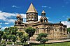
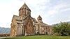
 Church of St. Grigoris of the Amaras Monastery (established in the 4th century, rebuilt in 1858) | |
| Religion | |
| Affiliation | Armenian Apostolic Church |
| Location | |
| Location | near the village of Sos |
| Country | Artsakh (de facto) Azerbaijan (de jure) |
 Shown within Republic of Artsakh  Amaras Monastery (Azerbaijan) | |
| Geographic coordinates | 39°41′02″N 47°03′25″E / 39.684°N 47.057°E |
| Architecture | |
| Style | Armenian |
| Completed | 4th century (established); 1858 (rebuilt) |
| Website | |
| www.amaras.org | |
Amaras Monastery (Armenian: Ամարաս վանք) is an Armenian monastery[1] near the village of Sos, de facto in the Martuni Province of the Republic of Artsakh, de jure in the Khojavend District of Azerbaijan, in the disputed region of Nagorno-Karabakh.[2] It was a prominent religious and educational center in medieval Armenia.[3] The successor state of Azerbaijan does not recognize any Armenian Apostolic identity, instead referring to it as "Caucasian Albanian".[4]
History

.JPG)
4th–5th centuries
According to medieval chroniclers Faustus Byuzand and Movses Kaghankatvatsi, St. Gregory the Illuminator, the patron saint and evangelizer of Armenia, founded the Amaras Monastery at the start of the fourth century.[5][6]
Amaras was the burial place of St. Gregory the Illuminator's grandson, St. Grigoris (died in 338). A tomb built for his remains survives under the apse of the nineteenth-century Church of St. Grigoris.
At the beginning of the fifth century Mesrop Mashtots, the inventor of the Armenian alphabet, established in Amaras the first-ever school that used his script.[7][8]
Destruction and restoration (13th–19th centuries)
The monastery was plundered in the thirteenth century by the Mongols, destroyed in 1387 during Tamerlane's invasion, and demolished again in the sixteenth century. It underwent radical restructuring in the second quarter of the seventeenth century when the surviving defensive walls were constructed.
Amaras was later abandoned, and in the first half of the nineteenth century the monastery was used as a frontier fortress by Russian imperial troops.
The Armenian Apostolic Church reclaimed the monastery in 1848. The monastery's church appears to have been severely damaged during the period of military occupation, to the extent that a new church had to be constructed on the site of the old one. This new church, dedicated to St. Grigoris, was built in 1858 and paid for by the Armenians of the city of Shushi.
Tomb of St. Grigoris
St. Grigoris was originally buried at the eastern end of the now-vanished St. Gregory Church. Archeologists think that the eastern entrance of the tomb, which is unusual for traditional church architecture, is based on the Church of the Holy Sepulchre in Jerusalem.[9] In 489 Vachagan III the Pious, king of Caucasian Albania, renovated Amaras, restoring the church and constructing a new chapel for the remains of St. Grigoris. In later centuries, a church was built over this chapel-tomb.
Under the altar of the St. Grigoris church is a tomb chamber, reached at its western end by twin flights of steps. A blocked passage at its eastern end indicates that there was originally an entrance from that direction as well. The barrel-vaulted tomb chamber is 1.9 m wide, 3.75 m long, and 3.5 m high. The upper half of the structure originally projected 1.5 to 2 m above ground level, but it is now entirely underground. Carved details date it stylistically to the 5th century.[10]
Gallery
-
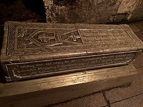 Sarcophagus of St. Grigoris in the funeral crypt
 -
 Protective walls
 -
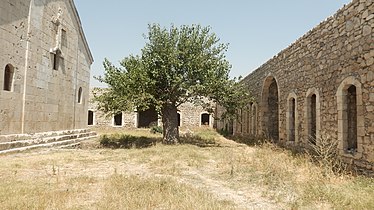 Courtyard
 -
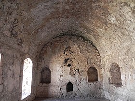 Monastery vaults
 -
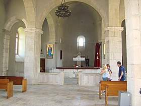 Church of St. Grigoris interior

.jpg)
.jpg)
.JPG)

See also
References
- ^ Thomas De Waal/ The Caucasus: An Introduction/ Oxford University Press -2018, p.103- pp.312
The demographics of the region have fluctuated sharply over time, but an Armenian presence has been recorded there off and on for centuries, and the hills are dotted with medieval Armenian churches, such as Amaras and Gandzasar.
- ^ Khatcherian, Hrair. Artsakh: A Photographic Journey. Eastern Prelacy of the Armenian Apostolic Church of America, 1997, p. 6. OCLC 37785365
- ^ Hasratyan, M. M. (1975). "Ամարասի ճարտարապետական համալիրը [Architectural complex of Amaras]". Lraber Hasarakakan Gitutyunneri (in Armenian) (5): 35–52.
- ^ "Amaras məbədi - XOCAVƏND RAYON Icra Hakimiyyəti". www.xocavend-ih.gov.az. Retrieved 2021-05-28.
- ^ Pavstos Byuzand. Armenian History. Yerevan. 1987. page 17
- ^ Movses Kaghankatvatsi. History of Aluank. Book I. Chapter XIV.
After accepting the rank of [the country's] high priest, he left to enlighten the countries of Iberia and Aluank. He arrived in the ghavar of Haband and preached and admonished not to break the commandments of the Son of God. Here he began the building of a church in Amaras and hired workers and foremen to finish it. After returning to Armenia, he consecrated and appointed instead of himself his son Vrtanes, filled with his father's virtues, who lived according to the [Christian] teaching and punished and admonished all those who adhered to the heresy of idol-worship.
- ^ Viviano, Frank. "The Rebirth of Armenia", National Geographic Magazine, March 2004
- ^ John Noble, Michael Kohn, Danielle Systermans. Georgia, Armenia and Azerbaijan. Lonely Planet; 3 edition (May 1, 2008), p. 307
- ^ "Armenians displaced from Nagorno-Karabakh fear their medieval churches will be destroyed".
- ^ M. Hasratyan, "Amaras", Yerevan 1990.