Erhai Lake
| Er Lake / Erhai | |
|---|---|
 | |
| Location | Yunnan |
| Coordinates | 25°45′48″N 100°11′15″E / 25.76333°N 100.18750°E |
| Basin countries | China |
| Max. length | 40 km (25 mi) |
| Max. width | 8 km (5.0 mi) |
| Surface area | 250 km2 (97 sq mi) |
| Average depth | 11 m (36 ft) |
| Water volume | 2.5 km3 (0.60 cu mi) |
| Surface elevation | 1,972 m (6,470 ft) |
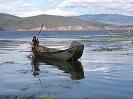
Er Lake or Erhai Lake, Chinese Erhai (ěrhǎi, 洱海), is an alpine fault lake in Yunnan province, China. Its name means "Ear-shaped Sea", due to its shape as seen by locals and travellers. Er Lake was also known as Yeyuze or Kunming Lake in ancient times.
Geography

Erhai is situated at 1,972 metres (6,470 ft) above sea level. In size, the North-South length of the lake is 40 kilometres (25 mi) and the East-West width is roughly 7–8 kilometres (4.3–5.0 mi). Its area is 250 square kilometres (97 sq mi), making it the second largest highland lake of China, after Dianchi Lake. Its circumference reaches 116 kilometres (72 mi), its average depth is of 11 metres (36 ft) and the total storage capacity of 2.5 billion cubic metres (2,000,000 acre⋅ft).
The lake is sandwiched between the Cangshan Mountains to the West and Dali City. It starts at Dengchuan at its northern extremity and finishes at Xiaguan city in the South, receiving water from the Miju and Mici Rivers (in the North), the Bolou River (in the East) and smallers streams from the Cangshan Mountains. Yangbi River is the lake's outlet in the South and eventually flows into the Lancang River (Mekong River).
Attractions

The lakeshore can be explored by hiking. Highlights include Erhai Lake Park and the Butterfly Springs on the Western bank. Islands on the lake – including Guanyin Ge, Jinsuo Island (金梭岛, "Golden Shuttle Island"), Nanzhao Folklore Island (南诏风情岛) and Xiaoputuo Island – are also available for visits.
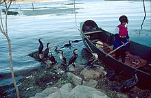
The lake is an important food source for the local people (Bais), who are famous for their fishing method: their trained cormorants catch fish and return them to fishmongers. The birds are prevented from swallowing their fish by rings fixed around their neck.
Biodiversity
Erhai also holds a high diversity of typical carps (Cyprinus), with for example the endemic species (C. barbatus, C. daliensis and the spring fish C. longipectoralis) being found only here. Zacco taliensis is another cyprinid endemic to Erhai.[1]
The lake used to be a royal deer ranch for the Nanzhao Kingdom.
References
- ^ Froese, Rainer; Pauly, Daniel (eds.) (2012). "Zacco taliensis" in FishBase. July 2012 version.
- Erhai Lake (chinaculture.org)
