Pune Camp
Pune Camp
Pune Cantonment Pune Camp, पुणे छावणी | |
|---|---|
city | |
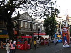
 MG Road in Pune Cantonment | |
 Pune Camp Location in Maharashtra, India | |
| Coordinates: 18°25′25″N 73°54′32″E / 18.42361°N 73.90889°E | |
| Country | |
| State | Maharashtra |
| Region | Paschim Maharashtra |
| Division | Pune |
| District | Pune |
| Established | 1817 |
| Talukas | Haveli taluka |
| Government | |
| • Body | Pune Cantonment Board |
| • Cantonment Executive Officer | Shri. Sanjeev Kumar[1] |
| Area | |
| • Total | 11.9 km2 (4.6 sq mi) |
| Elevation | 577 m (1,893 ft) |
| Population (2005)[2] | |
| • Total | 79,454 |
| • Density | 6,700/km2 (17,000/sq mi) |
| Languages | |
| • Official | Marathi |
| Time zone | UTC+5:30 (IST) |
| PIN | 411 0xx |
| Telephone code | (91)20 |
| Vehicle registration | MH 12 |
| Lok Sabha constituency | Pune |
| Vidhan Sabha constituency | Pune Cantonment |
| Civic agency | Pune Cantonment Board |
| Distance from Mumbai | 158 kilometres (98 mi) NNE (road) |
| Climate | Tropical Wet & Dry (Köppen) |
| Avg. annual temperature | 24 °C (75 °F) |
| Avg. summer temperature | 30 °C (86 °F) |
| Avg. winter temperature | 12 °C (54 °F) |
| Website | www |
Pune Cantonment, also known as Pune Camp, is a military cantonment located in Pune, Maharashtra in India. It was established in 1817 for accommodating troops of the British Indian Army. The cantonment houses many military establishments. It is also known for its many shopping locations like MG Road and East Street. The headquarters of Indian Army's Southern Command is located in Pune Cantonment. The National War Memorial Southern Command which commemorates the sacrifice of soldiers of the Indian Armed Forces is also situated in the cantonment.
History
The British Indian Army already had a small encampment west of the Mula River in Khadki. As more troops were required to be accommodated, a larger area was occupied to the west of the Mutha River, leading to the establishment of the Pune Cantonment in 1817[3] for accommodating troops of the British Indian Army. The villages of Mali, Munjeri, Wanowrie and Ghorpuri (Ghorpadi) were selected for this purpose.[4] Initially, a garrison for 4,620 troops was planned for the cantonment. This included two European regiments, a mountain battery, a native cavalry and three native regiments.[3] A central belt of 130 acres (0.53 km2) was designated for training and drills. The firing ranges were located at Golibar Maidan.[3] Soon a large number of civilians began settling in the area. This was encouraged since civilians provided services to troops garrisoned in the cantonment.


The limit of the cantonment were extended in 1822. In 1963, Ghorpuri Village (Ghorpadi) and Fatima Nagar were merged into cantonment area. The limit of the cantonment was again extended in the same year when Mundhwa village was included in the cantonment.
Government and politics
Pune Cantonment is a part of the Pune Lok Sabha constituency. Pune Cantonment is a separate constituency of the Maharashtra Legislative Assembly (Vidhan Sabha). The currently elected Member of Legislative Assembly from Pune Cantonment constituency is Dilip Kamble.[5]
Civic administration
The Pune Cantonment Board is responsible for the civic administration of the cantonment. Pune Cantonment is not a part of Pune Municipal Corporation, instead, the Chairman, Cantonment Board is the head of the civic administration within the Cantonment Board area. The Lashkar Police Station is responsible for maintaining law and order in Pune Cantonment.[6] The cantonment comes under Zone II of the Pune Police.
Transport
Pune Cantonment is connected by public transport buses operated by the Pune Mahanagar Parivahan Mahamandal Limited.[7] Autorickshaws are easily available in the cantonment. The NH-9 which connects Pune to Machilipatnam via Solapur and Hyderabad passes through the cantonment. The nearest rail link to the cantonment is the Pune Railway Station. The nearest airport is the Pune International Airport.
Utility services
The Pune Municipal Corporation supplies water to the residents of Pune Cantonment.[4] The Pune Cantonment Board has also set up public water posts for usage by economically backward sections. Electricity is distributed by the Maharashtra State Electricity Distribution Company Limited.
Cellular services
Cell phone coverage is extensive, and the main service providers are Vodafone Essar, Airtel, BSNL Mobile, Reliance GSM, Reliance CDMA Idea Cellular, Tata DoCoMo GSM, Tata DoCoMo CDMA, Jio, Aircel and Uninor.
Education
The Pune Cantonment Board runs three high schools and 6 primary schools in the cantonment area.[8] In addition to these, there are many other private schools and colleges in Pune Cantonment. The Armed Forces Medical College, a prominent landmark, is also located here.
Health
The Pune Cantonment Board runs the Cantonment General Hospital,[9] a 100 bedded hospital on the Solapur Road. It also runs 3 dispensaries in the Cantonment. A military hospital is also located in the cantonment. Also the Ruby Hall Clinic, the Jehangir Hospital (both privately operated) and the Sassoon Hospital (state operated) are located in the vicinity of the cantonment.
See also
References
- ^ http://www.punecantonmentboard.org/New_HTML/About_Us.htm
- ^ "Cities in India". Retrieved 16 January 2010.
- ^ a b c "History of the Southern Command". Retrieved 4 December 2010.
- ^ a b "Pune Cantonment Administration Report". Retrieved 28 November 2009.
- ^ http://myneta.info/maharashtra2014/candidate.php?candidate_id=982
- ^ "Pune Police Stations". Retrieved 15 January 2010.
- ^ "PMPML". Archived from the original on December 5, 2009. Retrieved 19 December 2009.
{{cite web}}: Unknown parameter|deadurl=ignored (|url-status=suggested) (help) - ^ "PCB Admin Report". Retrieved 28 November 2009.
- ^ "Pune Cantonment Board". Retrieved 25 November 2009.


