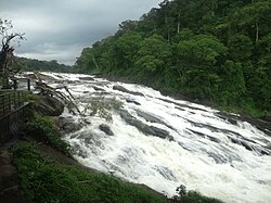
Vazhachal Falls
Tools
Actions
General
Print/export
Print/export
In other projects
From Wikipedia, the free encyclopedia
This is an old revision of this page, as edited by Frietjes (talk | contribs) at 15:52, 12 January 2017. The present address (URL) is a permanent link to this revision, which may differ significantly from the current revision.
Waterfall in Kerala, India
| Vazhachal Falls | |
|---|---|
| വാഴച്ചാൽ വെള്ളച്ചാട്ടം | |
 Vazhachal Falls | |
 | |
| Location | Thrissur District, Kerala, India |
| Coordinates | 10°18′5.12″N 76°35′33.95″E / 10.3014222°N 76.5927639°E / 10.3014222; 76.5927639 |
| Elevation | 120 m (390 ft) |
| Watercourse | Chalakkudi River |
Vazhachal Falls is situated in Athirappilly Panchayath of Thrissur district in Kerala on the southwest coast of India. Located on the west-flowing Chalakudy River near the Vazhachal Forest Division and at the edge of the Sholayar ranges, it is just 5 km from entrance of Athirappilly Falls. It is located 36 km from Chalakudy.[1][2][3][4]


References
- ^ "thirapally and Vazhachal Waterfalls, Thrissur". Kerala Tourism. Retrieved 2013-06-19.
- ^ "About Vazhachal Falls". Holidayiq. Retrieved 2013-06-19.
- ^ "Athirapally Waterfalls". Kerala Greenery. Retrieved 2013-06-19.
- ^ "ATHIRAPPILLY". Webindia.com. Retrieved 2013-06-19.
See also
- Athirappilly Falls
- Charpa Falls
- Chalakudy
- List of waterfalls in India
- List of waterfalls in India by height
External links
Wikimedia Commons has media related to Vazhachal Falls.
Tourist attractions in Thrissur | ||
|---|---|---|
| Dams | ||
| Beaches and waterfalls | ||
| Forts and palaces | ||
| Boatraces | ||
| Parks and zoos | ||
| Exhibitions and film festivals | ||
| Buildings | ||
| Festivals | ||
| Prehistoric | ||
| Museums | ||
This article related to a location in Thrissur district, Kerala, India is a stub. You can help Wikipedia by expanding it. |

