
Prefectures of Japan: Difference between revisions
Curb Chain (talk | contribs) →List in alphabetical order: this is sortable |
Curb Chain (talk | contribs) removed wordy heading |
||
| Line 55: | Line 55: | ||
== Lists of prefectures == |
== Lists of prefectures == |
||
===List in ISO order===<!-- Note to editors: The article [[Japan]] links to this header. If you alter this header, kindly alter the link to it in [[Japan]]. Fg2 June 28, 2006 --> |
|||
The prefectures are also often grouped into nine [[Regions of Japan|regions]] (''Chihō''). Those regions are not formally specified, they do not have elected officials, nor are they corporate bodies. However, the practice of ordering prefectures based on their geographic location is common. From north to south (numbering in [[ISO 3166-2:JP]] order), the prefectures of Japan and their commonly associated regions are: |
The prefectures are also often grouped into nine [[Regions of Japan|regions]] (''Chihō''). Those regions are not formally specified, they do not have elected officials, nor are they corporate bodies. However, the practice of ordering prefectures based on their geographic location is common. From north to south (numbering in [[ISO 3166-2:JP]] order), the prefectures of Japan and their commonly associated regions are: |
||
Revision as of 12:18, 6 December 2012

The prefectures of Japan are the country's 47 first-order subnational jurisdictions on a state or provincial level: one "metropolis" (都 to), Tokyo; one "circuit"/territory (道 dō), Hokkaidō; two urban prefectures (府 fu), Osaka and Kyoto; and 43 other prefectures (県 ken). Prefectures are governmental bodies larger than cities, towns, and villages. The prefecture system was established in 1871 during the Meiji Restoration.
The chief executive of each prefecture is a directly elected governor (ja:知事, chiji). Ordinances and budgets are enacted by a unicameral (single chamber) assembly (議会, gikai) whose elected members serve four-year terms.
Under the current Local Autonomy Law, each prefecture is further subdivided into cities (市 shi) and districts (郡 gun). Each district is further subdivided into towns (町 chō or machi) and villages (村 son or mura). For example, Hokkaidō has 14 subprefectures which act as branch offices (支庁 shichō) of the prefecture. Some other prefectures also have branch offices, which carry out prefectural administrative functions outside the capital. Tokyo, the capital is a merged city-prefecture, it has features of both cities and prefectures.
Historical background
The origins of the Western term prefecture being used to describe Japanese subdivisions date from 15th century Portuguese contact with Japan, whereby the word prefeitura was used to very roughly describe Japanese fiefdoms, in Portuguese the original meaning was more analogous to municipalities than provinces.
Those fiefs were headed by a local warlord or family, and despite that those fiefs have long since been dismantled, merged, and reorganized numerous times over, and given legislative governance and oversight, the rough translation stuck.
The current system was established by the Meiji government in July 1871 with the abolition of the han system and establishment of the prefecture system (廃藩置県 haihan-chiken). Although there were initially over 300 prefectures, many of them being former han territories, this number was reduced to 72 in the latter part of 1871, and 47 in 1888. The Local Autonomy Law of 1947 gave more political power to prefectures, and installed prefectural governors and parliaments.
In 2003, then-Prime Minister Junichiro Koizumi proposed that the government consolidate the current prefectures into about 10 regional states. The plan called for each region to have greater autonomy than existing prefectures. This process would reduce the number of sub-prefecture administrative regions and cut administrative costs.[1] The Japanese government is also considering a plan by which several groups of prefectures would merge, creating a sub-national administrative division system consisting of between nine and thirteen states, and giving these states more local autonomy than the current prefectures enjoy.[2] As of August 2012[update], no reorganization has been scheduled.
Types of prefectures
In the Japanese language there are four different terms for prefectures. The prefectures are sometimes collectively referred to as to-dō-fu-ken (都道府県) in Japanese, which is a simple combination of the four terms.
Historically, during the Edo period, the Tokugawa shogunate established bugyō-ruled zones (奉行支配地) around the nine largest cities in Japan, and 302 township-ruled zones (郡代支配地) elsewhere. When the Meiji government began to create the prefectural system in 1868, the nine bugyō-ruled zones became fu (府), while the township-ruled zones and the rest of the bugyo-ruled zones became ken (県). Later, in 1871, the government designated Tokyo, Osaka, and Kyoto as fu, and relegated the other fu to the status of ken. During World War II, in 1943, Tokyo became a to, a new type of pseudo-prefecture (see below).
Despite the differences in terminology, there is little functional difference between the four types of prefecture.
Ken
43 of the 47 prefectures are referred to as ken (県). The Classical Chinese character from which this is derived carries a rural or provincial connotation, and an analogous character is used to refer to the counties of China and counties of Taiwan.
Fu (Osaka/Kyoto)
Osaka and Kyoto Prefectures are referred to as fu (府). The Classical Chinese character from which this is derived implies a core urban zone of national importance. Before World War II, different laws applied to fu and ken, but this distinction was abolished after the war, and the two types of prefecture are now functionally the same.
To (Tokyo)
Tokyo is referred to as to (都), which is often translated as "metropolis." The Japanese government still translates Tōkyō-to as "Tokyo Metropolis" in almost all cases, and the government is officially called the "Tokyo Metropolitan Government". However, some people still call Tōkyō-to "Tokyo Prefecture" in English.
Following the abolition of the han system, Tōkyō-fu (an urban prefecture like Kyoto and Osaka) encompassed a number of cities, the largest of which was Tokyo City. Tokyo City was divided into 15 wards. In 1943, Tokyo City was abolished, Tōkyō-fu became Tōkyō-to, and Tokyo's wards became the special wards, local authorities falling directly under the prefecture in hierarchy, each with their own elected assemblies (kugikai) and mayors (kuchō). A number of suburban villages and towns of Tokyo City were changed to wards, bringing the total number of special wards to 35. The reason for this reorganization was to consolidate the administration of the area around the capital by eliminating the extra level of authority in Tokyo. The central government wanted to have a greater degree of control over Tokyo due to Japan's deteriorating position in World War II and the possibility of emergency in the metropolis.
After the war, Japan was forced to decentralize Tokyo again, following the general terms of democratization outlined in the Potsdam Declaration. Many of Tokyo's special governmental characteristics disappeared during this time, and the wards took on an increasingly municipal status in the decades following the surrender. Administratively, today's special wards are almost indistinguishable from other municipalities.
The postwar reforms also changed the map of Tokyo significantly. In 1947, the 35 wards were reorganized into the 23 special wards, because many had died in the bombardments during the war, many survivors had left the city, and many men who had been drafted had not returned.
There are some differences in terminology between Tokyo and other prefectures: police and fire departments are called chō (庁) instead of honbu (本部), for instance. However, the only functional difference between Tōkyō-to and other prefectures is that Tokyo administers wards as well as cities. Today, since the special wards have almost the same degree of independence as Japanese cities, the difference in administration between Tokyo and other prefectures is fairly minor (see 23 special wards for details).
In Osaka, several prominent politicians led by Governor Toru Hashimoto are currently proposing an Osaka Metropolis plan, under which the city of Osaka, and possibly other neighboring cities, would be replaced by special wards similar to Tokyo's.
Dō (Hokkaido)
Hokkaido is referred to as a dō (道) or circuit. This term was originally used to refer to regions of Japan consisting of several provinces (e.g. the Tōkaidō east coast region and Saikaidō west coast region). This was also an historical usage of the character in China.
Hokkaidō, the only remaining dō today, was not one of the original seven dō (it was known as Ezo in the pre-modern era). Its current name is believed to originate from Matsuura Takeshiro, an early Japanese explorer of the island. Since Hokkaidō did not fit into the existing dō classifications, a new dō was created to cover it.
The Meiji government originally classified Hokkaidō as a "Settlement Envoyship" (開拓使 kaitakushi), and later divided the island into three prefectures (Sapporo, Hakodate, and Nemuro). These were consolidated into a single Hokkaidō Department (北海道庁 Hokkaidō-chō) in 1886, at prefectural level but organized more along the lines of a territory. In 1947, the Department was dissolved, and Hokkaidō became a full-fledged prefecture. The -ken suffix was never added to its name, so the -dō suffix came to be understood to mean "prefecture."
When Hokkaidō was incorporated, transportation on the island was still very underdeveloped, so the prefecture was split into several "sub-prefectures" (支庁 shichō) that could fulfill administrative duties of the prefectural government and keep tight control over the developing island. These sub-prefectures still exist today, although they have much less power than they possessed before and during World War II: they now exist primarily to handle paperwork and other bureaucratic functions.
"Hokkaidō Prefecture" is, technically speaking, a redundant term, although it is occasionally used to differentiate the government from the island itself. The government of the prefecture calls itself the "Hokkaidō Government" rather than the "Hokkaidō Prefectural Government".
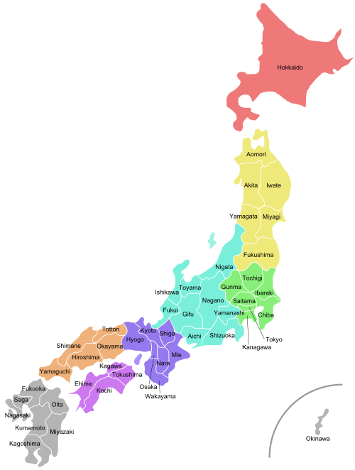
Lists of prefectures
The prefectures are also often grouped into nine regions (Chihō). Those regions are not formally specified, they do not have elected officials, nor are they corporate bodies. However, the practice of ordering prefectures based on their geographic location is common. From north to south (numbering in ISO 3166-2:JP order), the prefectures of Japan and their commonly associated regions are:
|
1. Hokkaidō 2. Aomori 8. Ibaraki |
15. Niigata 24. Mie 31. Tottori |
36. Tokushima 40. Fukuoka 47. Okinawa |
 |
| Prefecture | Japanese | Capital | Region | Major Island | Population¹ | Area² | Density³ | Distr. | Municip. | ISO |
|---|---|---|---|---|---|---|---|---|---|---|
| 愛知県 | Nagoya | Chūbu | Honshū | 7,043,235 | 5,153.81 | 1,366 | 7 | 54 | JP-23 | |
| 秋田県 | Akita | Tōhoku | Honshū | 1,189,215 | 11,612.11 | 102 | 6 | 25 | JP-05 | |
| 青森県 | Aomori | Tōhoku | Honshū | 1,475,635 | 9,606.26 | 154 | 8 | 40 | JP-02 | |
| 千葉県 | Chiba | Kantō | Honshū | 5,926,349 | 5,156.15 | 1,149 | 6 | 54 | JP-12 | |
| 愛媛県 | Matsuyama | Shikoku | Shikoku | 1,493,126 | 5,676.44 | 263 | 7 | 20 | JP-38 | |
| 福井県 | Fukui | Chūbu | Honshū | 828,960 | 4,188.76 | 198 | 7 | 17 | JP-18 | |
| 福岡県 | Fukuoka | Kyūshū | Kyūshū | 5,015,666 | 4,971.01 | 1,009 | 12 | 60 | JP-40 | |
| 福島県 | Fukushima | Tōhoku | Honshū | 2,126,998 | 13,782.54 | 154 | 13 | 59 | JP-07 | |
| 岐阜県 | Gifu | Chūbu | Honshū | 2,107,687 | 10,598.18 | 199 | 9 | 42 | JP-21 | |
| 群馬県 | Maebashi | Kantō | Honshū | 2,024,820 | 6,363.16 | 318 | 7 | 35 | JP-10 | |
| 広島県 | Hiroshima | Chūgoku | Honshū | 2,878,949 | 8,476.95 | 340 | 5 | 23 | JP-34 | |
| 北海道 | Sapporo | Hokkaidō | Hokkaidō | 5,682,950 | 83,452.47 | 68 | 66 | 180 | JP-01 | |
| 兵庫県 | Kobe | Kansai | Honshū | 5,550,742 | 8,392.42 | 661 | 8 | 41 | JP-28 | |
| 茨城県 | Mito | Kantō | Honshū | 2,985,424 | 6,095.62 | 490 | 7 | 44 | JP-08 | |
| 石川県 | Kanazawa | Chūbu | Honshū | 1,180,935 | 4,185.32 | 282 | 5 | 19 | JP-17 | |
| 岩手県 | Morioka | Tōhoku | Honshū | 1,416,198 | 15,278.51 | 93 | 10 | 33 | JP-03 | |
| 香川県 | Takamatsu | Shikoku | Shikoku | 1,022,843 | 1,861.70 | 549 | 5 | 17 | JP-37 | |
| 鹿児島県 | Kagoshima | Kyūshū | Kyūshū | 1,786,214 | 9,132.42 | 196 | 8 | 43 | JP-46 | |
| 神奈川県 | Yokohama | Kantō | Honshū | 8,489,932 | 2,415.42 | 3,515 | 6 | 33 | JP-14 | |
| 高知県 | Kōchi | Shikoku | Shikoku | 813,980 | 7,104.70 | 115 | 6 | 34 | JP-39 | |
| 熊本県 | Kumamoto | Kyūshū | Kyūshū | 1,859,451 | 6,908.45 | 269 | 9 | 45 | JP-43 | |
| 京都府 | Kyoto | Kansai | Honshū | 2,644,331 | 4,612.93 | 573 | 6 | 26 | JP-26 | |
| 三重県 | Tsu | Kansai | Honshū | 1,857,365 | 5,760.72 | 322 | 7 | 29 | JP-24 | |
| 宮城県 | Sendai | Tōhoku | Honshū | 2,365,204 | 7,285.16 | 325 | 10 | 35 | JP-04 | |
| 宮崎県 | Miyazaki | Kyūshū | Kyūshū | 1,170,023 | 6,684.67 | 175 | 6 | 26 | JP-45 | |
| 長野県 | Nagano | Chūbu | Honshū | 2,214,409 | 12,598.48 | 163 | 14 | 77 | JP-20 | |
| 長崎県 | Nagasaki | Kyūshū | Kyūshū | 1,516,536 | 4,092.80 | 371 | 4 | 21 | JP-42 | |
| 奈良県 | Nara | Kansai | Honshū | 1,442,862 | 3,691.09 | 391 | 7 | 39 | JP-29 | |
| 新潟県 | Niigata | Chūbu | Honshū | 2,475,724 | 12,582.37 | 197 | 9 | 30 | JP-15 | |
| 大分県 | Ōita | Kyūshū | Kyūshū | 1,221,128 | 5,804.24 | 210 | 3 | 18 | JP-44 | |
| 岡山県 | Okayama | Chūgoku | Honshū | 1,950,656 | 7,008.63 | 278 | 10 | 27 | JP-33 | |
| 沖縄県 | Naha | Kyūshū | Ryukyu Islands | 1,318,281 | 2,271.30 | 580 | 5 | 41 | JP-47 | |
| 大阪府 | Osaka | Kansai | Honshū | 8,804,806 | 1,893.18 | 4,652 | 5 | 43 | JP-27 | |
| 佐賀県 | Saga | Kyūshū | Kyūshū | 876,664 | 2,439.23 | 359 | 6 | 20 | JP-41 | |
| 埼玉県 | Saitama | Kantō | Honshū | 6,938,004 | 3,767.09 | 1,827 | 8 | 63 | JP-11 | |
| 滋賀県 | Otsu | Kansai | Honshū | 1,342,811 | 4,017.36 | 334 | 3 | 19 | JP-25 | |
| 島根県 | Matsue | Chūgoku | Honshū | 761,499 | 6,707.32 | 114 | 5 | 19 | JP-32 | |
| 静岡県 | Shizuoka | Chūbu | Honshū | 3,767,427 | 7,328.61 | 484 | 5 | 35 | JP-22 | |
| 栃木県 | Utsunomiya | Kantō | Honshū | 2,004,787 | 6,408.28 | 313 | 5 | 26 | JP-09 | |
| 徳島県 | Tokushima | Shikoku | Shikoku | 823,997 | 4,145.26 | 199 | 8 | 24 | JP-36 | |
| 東京都 | Shinjuku | Kantō | Honshū | 12,059,237 | 2,187.08 | 5,514 | 1 | 39 | JP-13 | |
| 鳥取県 | Tottori | Chūgoku | Honshū | 613,229 | 3,507.19 | 175 | 5 | 19 | JP-31 | |
| 富山県 | Toyama | Chūbu | Honshū | 1,120,843 | 4,247.22 | 264 | 2 | 15 | JP-16 | |
| 和歌山県 | Wakayama | Kansai | Honshū | 1,069,839 | 4,725.55 | 226 | 6 | 30 | JP-30 | |
| 山形県 | Yamagata | Tōhoku | Honshū | 1,244,040 | 9,323.34 | 133 | 8 | 35 | JP-06 | |
| 山口県 | Yamaguchi | Chūgoku | Honshū | 1,528,107 | 6,110.76 | 250 | 4 | 19 | JP-35 | |
| 山梨県 | Kofu | Chūbu | Honshū | 888,170 | 4,465.37 | 199 | 5 | 27 | JP-19 |
Notes: ¹ as of 2000; ² km²; ³ per km²
Former prefectures
In Japan
- Anotsu Prefecture merged into Mie
- Chikuma Prefecture merged into Nagano
- Kokura Prefecture merged into Fukuoka
Territories lost after World War II
- To Soviet Union/Russia (chō)
- To Republic of China (Taiwan) (shū and chō)
- To North Korea (dō)
- Heian-hokudō (North Pyongan Province)
- Heian-nandō (South Pyongan Province)
- Kōkaidō (Hwanghae Province)
- Kankyō-hokudo (North Hamgyong Province)
- Kankyō-nandō (South Hamgyong Province)
- part of Kōgendō (Kangwon Province)
- To South Korea (dō)
- Keikidō (Gyeonggi Province)
- Chūsei-hokudō (North Chungcheong Province)
- Chūsei-nandō (South Chungcheong Province)
- Zenra-hokudō (North Jeolla Province)
- Zenra-nandō (South Jeolla Province)
- Keishō-hokudō (North Gyeongsang Province)
- Keishō-nandō (South Gyeongsang Province)
- part of Kōgendō (Gangwon Province)
See also
- List of Japanese prefectures by population
- List of Japanese prefectures ranked by area
- List of prefectural capitals in Japan
- List of regions in Japan
- ISO 3166-2 codes for Japan
- Government of Japan
- List of governors of Japan
See also
| Administrative divisions of Japan |
|---|
| Prefectural |
| Prefectures |
| Sub-prefectural |
| Municipal |
| Sub-municipal |
References
- ^ Mabuchi, Masaru, "Municipal Amalgamation in Japan", World Bank, 2001.
- ^ "Doshusei Regional System" National Association for Research Advancement.
External links
- National Governors' Association Website (English)
- Map of Japan showing prefectures
- Japanese essay on types of prefectures
- Local Authorities for International Relations (English)
- CityMayors.com profile of prefectures

| History |
| ||||||||||||
|---|---|---|---|---|---|---|---|---|---|---|---|---|---|
| Geography | |||||||||||||
| Politics |
| ||||||||||||
| Economy | |||||||||||||
| Society | |||||||||||||