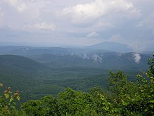
Ouachita Mountains


The Ouachita Mountains are a mountain range located in west central Arkansas and southeastern Oklahoma. The range's subterranean roots may extend as far as central Texas, or beyond it to the current location of the Marathon Uplift. Along with the Ozark Mountains, the Ouachita (pronounced [wɑˈʃiɾə], pseudophonetically: "wah-shi-tah") Mountains form the U.S. Interior Highlands, the only major mountainous region between the Rocky Mountains and the Appalachian Mountains.[1][2]
Geology and physiography
The Ouachita Mountains are a physiographic section of the larger Ouachita province (which includes both the Ouachita Mountains and the Arkansas Valley), which in turn is part of the larger Interior Highlands physiographic division.[3]
The Ouachita Mountains are fold mountains like the Appalachian Mountains to the east, and were originally part of that range. During the Pennsylvanian part of the Carboniferous period, about 300 million years ago, the coastline of the Gulf of Mexico ran through the central parts of Arkansas. As the South American plate drifted northward, a subduction zone was created in this region. The South American oceanic crust was forced underneath the less-dense North American continental crust. Geologists call this collision the Ouachita orogeny. The collision buckled the continental crust, producing the fold mountains we call the Ouachitas. At one time the Ouachita Mountains were very similar in height to the current elevations of the Rocky Mountains. Due to the Ouachitas' age, the craggy tops have eroded away leaving the low formations that used to be the heart of the mountains.
Unlike most other mountain ranges in the United States, the Ouachitas run east and west rather than north and south. Also, Ouachitas are distinctive in that volcanism, metamorphism, and intrusions are notably absent throughout most of the system.
The Ouachitas are noted for quartz crystal deposits around the Mount Ida area and for renowned Arkansas novaculite whetstones. This quartz was formed during the Ouachita orogeny, as folded rocks cracked and allowed fluids from deep in the Earth to fill the cracks. After intense pressure these areas became quartz.
The Ouachita Mountain area of Arkansas is dominated by Pennsylvanian classic sediments, known as the Atoka and Collier series. The Atoka Formation, formed in the Pennsylvanian Period, is a sequence of marine, mostly tan to gray silty sandstones and grayish-black shales. Some rare calcareous beds and siliceous shales are known. The Collier sequence is composed of gray to black, lustrous shale containing occasional thin beds of dense, black, and intensely fractured chert. An interval of bluish-gray, dense to spary, thin-bedded limestone may be present. Near its top, the limestone is conglomeratic and pelletoidal, in part, with pebbles and cobbles of limestone, chert, meta-arkose, and quartz. It was formed during the Late Cambrian.
Flora
The mountains are known to contain at least 15 endemic plant species (i.e. plants that occur nowhere else). These include Sabatia arkansana, Valerianella nuttallii, Liatris compacta and Quercus acerifolia.[4]
Tourism
The Ouachita Mountains contain the Ouachita National Forest and Hot Springs National Park as well as numerous state parks and scenic byways. They also contain the Ouachita National Recreation Trail, a 223 mile long hiking trail through the heart of the mountains. The trail runs from Talimena State Park in Oklahoma to Pinnacle Mountain State Park, near Little Rock, Arkansas. It is a well maintained, premier trail for hikers, backpackers, and mountain bikers (for only selected parts of the trail).
History
The area was well-known to Native Americans, who named the mountain 'Washitah' which meant 'good hunting grounds'. Later French explorers translated the name to its present spelling. The first recorded exploration was in 1541 by Hernando de Soto. Later, in 1804, President Jefferson sent William Dunbar and Dr. George Hunter to the area after the Louisiana Purchase. Hot Springs National Park became one of the nation's first parks in 1832. The Battle of Devil's Backbone was fought here at the ridge of the same name in 1863. In August 1990, the Forest Service discontinued clear-cutting as the primary tool for harvesting and regenerating short leaf, pine and hardwood forests on the Ouachita National Forest.
References
- ^ "Managing Upland Forests of the Midsouth". United States Forestry Service. Retrieved 2007-10-13.
- ^ "A Tapestry of Time and Terrain: The Union of Two Maps - Geology and Topography". United States Geological Survey. Retrieved 2007-10-13.
- ^ "Physiographic divisions of the conterminous U. S." U.S. Geological Survey. Retrieved 2007-12-06.
- ^ Pringle, J. S.; Witsell, T. (2005), "A new species of Sabatia (Gentianaceae) from Saline County, Arkansas" (PDF), Sida, 21 (3): 1249–1262, retrieved 2007-07-10
{{citation}}: Check date values in:|accessdate=(help)CS1 maint: multiple names: authors list (link)

