
Ho Chi Minh City
Ho Chi Minh City/Saigon
Thành phố Hồ Chí Minh Formerly Saigon (Vietnamese: Sài Gòn) | |
|---|---|
| Clockwise from right: Ho Chi Minh City skyline, Ho Chi Minh City Museum, Reunification Palace, & Ben Thanh Market Clockwise from right: Ho Chi Minh City skyline, Ho Chi Minh City Museum, Reunification Palace, & Ben Thanh Market | |
 Location in Vietnam | |
| Country | |
| Founded | 1698 |
| Renamed | 1976 |
| Government | |
| • Party Secretary | Lê Thanh Hải |
| • People's Committee Chairman: | Lê Hoàng Quân |
| • People's Council Chairwoman: | Phạm Phương Thảo |
| Area | |
| • Total | 809.23 sq mi (2,095 km2) |
| Elevation | 63 ft (19 m) |
| Population (Census April 1, 2009)[1] | |
| • Total | 7,123,340 |
| • Density | 8,805/sq mi (3,401/km2) |
| Time zone | UTC+7 |
| • Summer (DST) | UTC+7 |
| Area code | +84 (8) |
| Website | www.hochiminhcity.gov.vn |
Ho Chi Minh City (Saigon) (Vietnamese: Thành phố Hồ Chí Minh) is the largest city in Vietnam. It was once known as Prey Nokor, an important Khmer seaport prior to annexation by the Vietnamese in the 17th century.
Under the name Saigon (Vietnamese: Sài Gòn; ), it was the capital of the French colony of Cochinchina and later of the independent state of South Vietnam from 1954 to 1975. In 1976, Saigon merged with the surrounding province of Gia Định and was officially renamed Hồ Chí Minh City (although the name Sài Gòn—formally known as District 1—is still commonly used.)[2]
The city center is situated on the banks of the Saigon River, Template:Km to mi from the South China Sea[3] and Template:Km to mi south of Hanoi, the capital of Vietnam.
The metropolitan area, which consists of the Hồ Chí Minh City metropolitan area, Thủ Dầu Một, Dĩ An, Biên Hòa and surrounding towns, is populated by more than 9 million people,[4] making it the most populous metropolitan area[5] in Vietnam and the countries of the former French Indochina. The Greater Ho Chi Minh City Metropolitan Area, a metropolitan area covering most parts of Đông Nam Bộ plus Tiền Giang and Long An provinces under planning will have an area of 30,000 square kilometers with a population of 20 million inhabitants by 2020.[6]
Name
Traditional Vietnamese Name
After Prey Nokor was settled by Vietnamese refugees from the north, in time it came to be known unofficially as Sài Gòn. There is much debate about the origins of the Vietnamese name, Sài Gòn, the etymology of which is analyzed below.
However, before the French colonization the official Vietnamese name of Saigon was Gia Định (Chữ Nôm: 嘉定). In 1862, the French discarded this official name and adopted the name "Saigon", which had always been the popular name, although it was still written as 嘉定 on sinitic maps until at least 1891.[7]
The Vietnamese name, Sài Gòn, is sometimes written in two words, which is the traditional convention in Vietnamese spelling. Some people, however, write the name of the city as “SaiGon” or “Saigon” in order to save space or give it a more Westernized look.
Sino-Vietnamese etymology
A frequently heard, and reasonable, explanation is that Sài is a Chinese loanword (Chinese: 柴, pronounced chái in Mandarin) meaning “firewood, lops, twigs; palisade”, while Gòn is another Chinese loanword (Chinese: 棍, pronounced gùn in Mandarin) meaning “stick, pole, bole”, and whose meaning evolved into “cotton” in Vietnamese (bông gòn, literally “cotton stick”, i.e., “cotton plant”, then shortened to gòn).[8]
Some people say that this name originated from the many cotton plants that the Khmer people had planted around Prey Nokor, and which can still be seen at Cây Mai temple and surrounding areas.[8]
Another explanation is that the etymological meaning “twigs” (sài) and “boles” (gòn) refers to the dense and tall forest that once existed around the city, a forest to which the Khmer name, Prey Nokor, already referred.
In Chinese, the city is referred to as 西貢, pronounced “sai gung” in Cantonese, "sai goong" in Teochew and xīgòng in Mandarin. This represents “Saigon” written phonetically.
Cantonese etymology
Another reasonable etymology was offered by Vương Hồng Sển, a Vietnamese scholar in the early 20th century, who asserted that Sài Gòn had its origin in the Cantonese name of Cholon (Vietnamese: quoc ngu Chợ Lớn; chu nom File:Cholon.png) , the Chinese district of Saigon. The Cantonese (and original) name of Cholon is "Tai-Ngon" (堤岸), which means "embankment" (French: quais). The theory posits that "Sài Gòn" derives from "Tai-Ngon".
Khmer etymology
Another etymology often proposed, although held now as a least-likely etymology, is that “Saigon” comes from “Sai Côn”, which would be the transliteration of the Khmer word, Prey Nokor (Khmer: File:PreyNokor.png), meaning “god or heavenly”. Nokor is a Khmer word of Sanskrit origin meaning "city, land").
This Khmer etymology theory is quite interesting, given the Khmer context that existed when the first Vietnamese settlers arrived in the region. However, it fails to completely explain how Khmer “prey” led to Vietnamese "sài", since these two syllables appear phonetically quite distinct and as the least reasonable and least likely candidate from the Khmer etymology.
"Prey" is forest/jungle in Khmer. Nokor is Kingdom/city/land in Khmer. So, "Prey Nokor" is literally Forest Kingdom.
Current Vietnamese name
Immediately after the communist takeover of South Vietnam in 1975, a provisional government renamed the city after Hồ Chí Minh, the pre-eminent but by-then deceased North Vietnamese leader. The official name is now Thành phố Hồ Chí Minh, abbreviated Tp. HCM. In English, this is translated as Hồ Chí Minh City, abbreviated HCMC, and in French it is translated as Hô Chi Minh Ville (the circumflex is sometimes omitted), abbreviated HCMV. Sài Gòn is still the most common way to refer to the city in conversation inside Vietnam. Sài Gòn is used officially to refer to District 1; for example, in bus destinations. The name is also found in company names, book titles and even on airport departure boards (the code for Tân Sơn Nhất International Airport is SGN). Also, most Vietnamese that fled the country during the communist takeover do not recognize the name “Hồ Chí Minh City”, and will only refer to the city as Saigon.
History
Early history
Hồ Chí Minh City began as a small fishing village known as Prey Nokor. The area that the city now occupies was originally swampland, and was inhabited by Khmer people for centuries before the arrival of the Vietnamese. It should be noted that in Khmer folklore southern Vietnam was given to the Vietnamese government as a dowry for the marriage of a Vietnamese princess to a Khmer prince in order to stop constant invasions and pillaging of Khmer villages.
Khmer Territory
Beginning in the early 17th century, colonization of the area by Vietnamese settlers gradually isolated the Khmer of the Mekong Delta from their brethren in Cambodia proper and resulted in their becoming a minority in the delta.
In 1623, King Chey Chettha II of Cambodia (1618—-1628) allowed Vietnamese refugees fleeing the Trịnh–Nguyễn civil war in Vietnam to settle in the area of Prey Nokor, and to set up a custom house at Prey Nokor. Increasing waves of Vietnamese settlers, which the Cambodian kingdom could not impede because it was weakened by war with Thailand, slowly Vietnamized the area. In time, Prey Nokor became known as Saigon.
Prey Nokor was the most important commercial seaport to the Khmers. The city’s name was changed by Vietnam to Sài Gòn and then Hồ Chí Minh City. The loss of the city prevented the Cambodians access to the South China Sea. Subsequently, the Khmers' access to the sea was now limited to the Gulf of Thailand. It began as a small fishing village known as Prey Nokor. The area that the city now occupies was originally swampland, and was inhabited by Khmer people for centuries before the arrival of the Vietnamese.
Nguyễn dynasty rule

In 1698, Nguyễn Hữu Cảnh, a Vietnamese noble, was sent by the Nguyễn rulers of Huế by sea[9] to establish Vietnamese administrative structures in the area, thus detaching the area from Cambodia, which was not strong enough to intervene. He is often credited with the expansion of Saigon into a significant settlement. A large Vauban citadel called Gia Định was built, which was later destroyed by the French over the battle of Chí Hoà (see Citadel of Saigon).
Colonial French era
Conquered by France in 1859, the city was influenced by the French during their colonial occupation of Vietnam, and a number of classical Western-style buildings in the city reflect this, so much so that Saigon was called "the Pearl of the Far East" (Hòn ngọc Viễn Đông) or "Paris in the Orient" (Paris Phương Đông).[10] Saigon had, in 1929, a population of 123,890, including 12,100 French.[11]
Capital of North Vietnam
Former Emperor Bảo Đại made Saigon the capital of the State of Vietnam in 1949 with himself as head of state. After the Việt Minh gained control of North Vietnam in 1954, it became common to refer to the Saigon government as “South Vietnam”. The government was renamed the Republic of Vietnam when Bảo Đại was deposed in 1955. Saigon and Cholon, an adjacent city with many Sino-Vietnamese residents, were combined into an administrative unit called Đô Thành Sài Gòn ("Capital City Saigon").
Post-Vietnam War and today
At the conclusion of the Vietnam War, on April 30, 1975, the city came under the control of the Vietnamese People's Army. Among Vietnamese diaspora communities and particularly the U.S., this event is commonly called the “Fall of Saigon,” while the communist Socialist Republic of Vietnam calls it the “Liberation of Saigon.”
In 1976, upon the establishment of the unified communist Socialist Republic of Vietnam, the city of Saigon (including Cholon), the province of Gia Ðịnh and two suburban districts of two other nearby provinces were combined to create Hồ Chí Minh City in honour of the late communist leader Hồ Chí Minh. The former name Saigon is still widely used by many Vietnamese, especially in informal contexts.[10] Generally, the term Saigon refers only to the urban districts of Hồ Chí Minh City. The word "Saigon" can also be found on shop signs all over the country, even in Hanoi.
Landmarks


Today, the city's core is still adorned with wide elegant boulevards and historic French colonial buildings. The most prominent structures in the city center are Reunification Palace (Dinh Thống Nhất), City Hall (Ủy ban nhân dân Thành phố), Municipal Theatre, Ho Chi Minh City (Nhà hát thành phố), City Post Office (Bưu điện thành phố), State Bank Office (Ngân hàng nhà nước), City People's Court (Tòa án nhân dân thành phố) and Notre-Dame Cathedral (Nhà thờ Đức Bà). Some of the historic hotels are the Hotel Majestic, dating from the French colonial era, and the Rex Hotel, Caravelle hotel some former hangouts for American officers and war correspondents in the 1960s and 1970s.
The city has various museums, such as the Ho Chi Minh City Museum, Museum of Vietnamese History and concerning modern history the Revolutionary Museum (Bảo tàng cách mạng) and the War Remnants Museum (Ho Chi Minh City). The Saigon Zoo and Botanical Gardens dates from 1865.
Population and new urban areas
Ho Chi Minh City is home to a well-established ethnic Chinese population. Cholon, which is made up of District 5 and parts of Districts 6, 10 and 11, serves as its Chinatown.
With a population now 7,123,340 (as of Census 2009 on April 1, 2009)[1] (registered residents plus migrant workers as well as a metropolitan population of 10 million), Ho Chi Minh City is in need of vast increase in public infrastructure.[12] To meet this need, the city and central governments have embarked on an effort to develop new urban centers. The two most prominent projects are the Thu Thiem city center in District 2 and the Phu My Hung Urban Area, a new City Center in District 7 (as part of the Saigon South project) where various international schools such as Saigon South International School, the Japanese school, Australia's Royal Melbourne Institute of Technology, the Taiwan and Korea schools are located. In December 2007, Phu My Hung New City Center completed the 17.8 km 10-14 lane wide Nguyen Van Linh Roadway linking the Saigon port areas, Tan Thuan Export Processing Zone to the National Highway 1 and the Mekong delta area. In November 2008, a brand new trade center, Saigon Exhibition and Convention Center, also opened its door. Other projects include Grandview, Waterfront, Sky Garden, Riverside and Phu Gia 99. Phu My Hung New City Center received the first Model New City Award from the Vietnamese Ministry of Construction.[13]
Geography and climate


Ho Chi Minh City is located at 10°45'N, 106°40'E in the southeastern region of Vietnam, 1,760 km (1,090 mi) south of Hanoi. The average elevation is 19 metres (62 feet) above sea level. It borders Tay Ninh and Binh Duong provinces to the north, Dong Nai and Ba Ria-Vung Tau provinces to the east, Long An Province to the west and the South China Sea to the south with a coast of 15 km in length. The city covers an area of 2,095 km2 (809 sq mi) (0.63% of the surface of Vietnam), extending up to Cu Chi (12 mi (19 km) from the Cambodian border), and down to Can Gio on the Vietnam East Sea coast. The distance from the northernmost point (Phu My Hung Commune, Cu Chi District) to the southernmost one (Long Hoa Commune, Can Gio District) is Template:Km to mi, and from the easternmost point (Long Binh Ward, District Nine) to the westernmost one (Binh Chanh Commune, Binh Chanh District) is Template:Km to mi.
The city has a tropical climate, specifically a tropical wet and dry climate, with an average humidity of 75%. A year is divided into two distinct seasons. The rainy season, with an average rainfall of about 1,800 millimetres (71 in) annually (about 150 rainy days per year), usually begins in May and ends in late November. The dry season lasts from December to April. The average temperature is 28 °C (82 °F), the highest temperature sometimes reaches 39 °C (102 °F) around noon in late April, while the lowest may fall below 16 °C (61 °F) in the early mornings of late December.
| Climate data for Ho Chi Minh City | |||||||||||||
|---|---|---|---|---|---|---|---|---|---|---|---|---|---|
| Month | Jan | Feb | Mar | Apr | May | Jun | Jul | Aug | Sep | Oct | Nov | Dec | Year |
| Source 1: World Meteorological Organisation (UN)[14] | |||||||||||||
| Source 2: Embassy of Vietnam, London[15] | |||||||||||||
Political and administrative system


Saigon is a municipality at the same level as Vietnam's provinces. The city has been divided into twenty-four administrative divisions since December 2003. Five of these {Area: 1,601 km2} are designated as rural (huyện). The rural districts are Nhà Bè, Cần Giờ, Hóc Môn, Củ Chi, and Bình Chánh. A rural district consists of communes (Xã) and townships (Thị trấn). The remaining districts {Area: 494 km2} are designated urban or suburban (quận). This includes districts one to twelve, as well as Tân Bình, Bình Thạnh, Phú Nhuận, Thủ Đức, Bình Tân, Tân Phú and Gò Vấp. Each quận is sub-divided into wards ("Phường"). Since December 2006, the city has had 259 wards, 58 communes and 5 townships (see List of HCMC administrative units below).[12]
People's Committee
The Ho Chi Minh City People's Committee is a 13-member executive council for the city. The current chairman is Le Hoang Quan. There are several vice chairmen and chairwomen on the committee with responsibility for various city departments. The legislative branch of the city government is called the People's Council and consists of 95 deputies. Both the committee and the council are subordinate to the city's Communist Party, currently led by Party Secretary Lê Thanh Hải. The chairman of the People's Committee is the No. 2 position in the city government while chairman of the People's Council is No. 3.
| List of HCMC Administrative Units | |||||||
|---|---|---|---|---|---|---|---|
| Name of district (since December 2003) | Sub-division units (since December 2006) | Area (km2) (since December 2006) | Population as of Census October 1, 2004 | Population as of Mid 2005 | Population as of Mid 2006 | Population as of Mid 2007 | Population as of Census April 1, 2009 |
| Inner Districts: | |||||||
| District 1 | 10 wards | 7.73 | 198,032 | 199,899 | 200,768 | 203,214 | 178,878 |
| District 2 | 11 wards | 49.74 | 125,136 | 126,084 | 130,189 | 133,257 | 145,981 |
| District 3 | 14 wards | 4.92 | 201,122 | 199,297 | 199,172 | 201,515 | 189,764 |
| District 4 | 15 wards | 4.18 | 180,548 | 185,268 | 189,948 | 190,325 | 179,640 |
| District 5 | 15 wards | 4.27 | 170,367 | 192,157 | 191,258 | 195,841 | 170,462 |
| District 6 | 14 wards | 7.19 | 241,379 | 243,416 | 248,820 | 252,816 | 251,912 |
| District 7 | 10 wards | 35.69 | 159,490 | 163,608 | 176,341 | 198,958 | 242,284 |
| District 8 | 16 wards | 19.18 | 360,722 | 366,251 | 373,086 | 380,330 | 404,976 |
| District 9 | 13 wards | 114 | 202,948 | 207,696 | 214,345 | 221,314 | 255,036 |
| District 10 | 15 wards | 5.72 | 235,231 | 235,370 | 238,799 | 241,052 | 227,226 |
| District 11 | 16 wards | 5.14 | 224,785 | 225,908 | 227,220 | 229,616 | 226,620 |
| District 12 | 11 wards | 52.78 | 290.129 | 299,306 | 306,922 | 329,751 | 401,894 |
| Go Vap District | 16 wards | 19.74 | 452,083 | 468,468 | 496,905 | 514,518 | 515,954 |
| Tan Binh District | 15 wards | 22.38 | 397,569 | 394,281 | 387,681 | 399,943 | 412,796 |
| Tan Phu District | 11 wards | 16.06 | 366,399 | 372,519 | 376,855 | 386,573 | 397,635 |
| Binh Thanh District | 20 wards | 20.76 | 423,896 | 435,300 | 449,943 | 468,208 | 451,526 |
| Phu Nhuan District | 15 wards | 4.88 | 175,293 | 175,716 | 175,825 | 180,511 | 174,497 |
| Thu Duc District | 12 wards | 47.76 | 336,571 | 346,329 | 356,088 | 368,032 | 442,110 |
| Binh Tan District | 10 wards | 51.89 | 398,712 | 403,643 | 447,173 | 469,201 | 572,796 |
| Total Inner Districts | 259 wards | 494.01 | 5,140,412 | 5,240,516 | 5,387,338 | 5,564,975 | 5,841,987 |
| Suburban Districts: | |||||||
| Cu Chi District | 20 communes and 1 township | 434.50 | 288,279 | 296,032 | 309,648 | 321,663 | 343,132 |
| Hoc Mon District | 11 communes and 1 township | 109.18 | 245,381 | 251,812 | 254,598 | 271,506 | 348,840 |
| Binh Chanh District | 15 communes and 1 township | 252.69 | 304,168 | 311,702 | 330,605 | 347,278 | 421,996 |
| Nha Be District | 6 communes and 1 township | 100.41 | 72,740 | 73,432 | 74,945 | 76,985 | 99,172 |
| Can Gio District | 6 communes and 1 township | 704.22 | 66,272 | 66,444 | 67,385 | 68,535 | 68,213 |
| Total Suburban Districts | 58 communes and 5 townships | 1,601 | 976,839 | 999,422 | 1,037,181 | 1,085,967 | 1,281,353 |
| Whole City | 259 wards, 58 communes and 5 townships | 2,095.01 | 6,117,251 | 6,239,938 | 6,424,519 | 6,650,942 | 7,123,340 |
Demographics

The population of Ho Chi Minh City, as of the October 1, 2004 Census, was 6,117,251 (of which 19 inner districts had 5,140,412 residents and 5 suburban districts had 976,839 inhabitants).[12] In the middle of 2007 the city's population was 6,650,942 (of which 19 inner districts had 5,564,975 residents and 5 suburban districts had 1,085,967 inhabitants). The result of Census 2009 shows that the city's population was 7,123,340 people[1] or about 8.3% of the total population of Vietnam; making it the highest population-concentrated city in the country. As an administrative unit, its population is also the largest at the provincial level. As the largest economic and financial hub of Vietnam, HCMC has attracted more and more immigrants from other Vietnamese provinces in recent years; therefore, its population is growing rapidly. Since 1999 the city population has increased by over 200,000 people per year.
The majority of the population are ethnic Vietnamese (Kinh) at about 90%. Other ethnic minorities include Chinese (Hoa) with 8%, (the largest Chinese community in Vietnam) and other minorities (Khmer, Cham, Nung, Rhade) 2%. [citation needed] The inhabitants of Ho Chi Minh City are usually known as "Saigonese" in English, "Saigonnais" in French and "dân Sài Gòn" in Vietnamese.
The Kinh speak Vietnamese with their respective regional accents: southern (about 50%), northern (30%) and central Vietnam (20%); while the Hoa- in addition- speak Cantonese, Teochew (Chaozhou), Hokkien, Hainanese and Hakka dialects of Chinese (only a few speak Mandarin Chinese). [citation needed] A varying degree of English is spoken especially in the tourism and commerce sectors where dealing with foreign nationals is a necessity, so English has become a de facto second language for some Saigonese. [citation needed]
According to some researchers[who?] the religious breakup in HCMC is as follows: Buddhism (all sects and/or including Taoism, Confucianism) 80%, Roman Catholic 11%, Protestant 2%, others (Cao Dai, Hoa Hao, Islam, Hinduism, Bahá'í Faith) 2%, and no religion or unknown 5%[citation needed].
Economy
Ho Chi Minh City is the most important economic center in Vietnam as it accounts for a high proportion of Vietnam's economy. Ho Chi Minh City plays an important driving impetus of Economy of Vietnam. This city just accounts for 0.6% land area, 7.5% population of Vietnam nevertheless accounts for 20.2% GDP, 27.9% industrial output and 34.9% FDI projects in this country in 2005.[16] In 2005, this city had 4,344,000 laborers, of which 130,000 are over the labor age norm (in Vietnam it’s 60 for male and 55 for female workers).[17] In 2009, GDP per capita reached 2,800 USD, compared to this country’s average level of $US 1042 in 2009.[18]
The economy of Ho Chi Minh City covers different fields, from mining, seafood processing, agriculture, construction to tourism, finance, industry, trading. The state-owned sector makes up 33.3%, private sector of 4.6%, the other remaining percentage lays in foreign businesses. As far as economic structure is concerned, service sector accounts for 51.1%, industry and construction accounts for 47.7%, forestry, agriculture and others make up just 1.2%.[19]
As of June of 2006, this city is home to 3 Export Processing Zones, 12 Industrial Parks.[20] Ho Chi Minh City is the leading FDI abosorber of Vietnam, with 2,530 FDI projects, 16.6 $ billion at the end of 2007.[21] In 2007, it got over 400 FDI projects with $US 3 billion.[22] In 2008, it attracted $US 8.5 billion from FDI.[23]
The consumption demand of Ho Chi Minh City is much higher than other provinces and municipalities of Vietnam, 1.5 times higher than that of Hanoi.[24]
Some 300,000 businesses, including many large enterprises, are involved in high-tech, electronic, processing and light industries, also in construction, building materials and agro-products. Also crude oil is a popular economic base in Ho Chi Minh City. Investors are still pouring money into the city. Total local private investment was 160,000 billion dong ($10 billion) with 18,500 newly founded companies. [citation needed] Investment is trended to hi-tech and services, real estate projects. Currently, the city has 15 industrial parks and export-processing zones, in addition to the Quang Trung Software Park and the Saigon Hi-Tech Park. Intel invested about 1 billion dollars in a factory in the city. There are 171 medium and large scale markets, several supermarket chains, shopping malls, fashion, and beauty centers. Additional malls and shopping plazas are being developed within the city. Over 50 banks with hundreds of branches and about 20 insurance companies are also located inside the city. [citation needed] The first stock exchange in Vietnam was opened in the city in 2001.
Quang Trung Software Park is a software park situated in District 12. The park is approximately 15 km from down town Saigon and hosts software enterprises, dot.com companies. The park also includes a software training school. Dot.com investors here are supplied with other facilities and services such as residences, high speed access to internet as well as favorable taxation. Together with the Hi-tech Park in District 9 and the 32 ha. software park inside Tan Thuan Export Processing Zone in District 7 of the city, Ho Chi Minh City is ambitious to become an important hi-tech city of the country and the South-East Asian region. This park helps the city in particular and Vietnam in general to be an outsourcing place for other enterprises in developed countries as India has performed.

In 2007, the city's Gross Domestic Product was estimated at $14.3 billion, or about $2,180 per capita, (up 12.6 percent on 2006) and accounting for 20 percent GDP of the country. The GDP adjusted to Purchasing Power Parity (PPP) reached $71.5 billion, or about $10,870 per capita (approximately 3 times higher than the country's average). The city's Industrial Product Value was $6.4 billion, equivalent to 30 percent of the whole nation. Export - Import Turnover through HCMC ports accounted for $36 billion, or 40 percent of the national total, of which, export revenue reached $18.3 billion (40 percent of Vietnam’s total export revenues). In 2007, Ho Chi Minh City contribution to the annual revenues in the national budget increased by 30 percent, accounting for about 20.5 percent of the total revenues.[25]
In 2007, 3 million foreign tourists, about 70 percent of total number of tourists to Vietnam, visited the city. Total cargo transport to Ho Chi Minh City’s ports reached 50.5 million metric tonnes, nearly one-third of the total for Vietnam.[26][27]
Education
There are many famous high schools in Ho Chi Minh City such as High School for the Gifted (Pho Thong Nang Khieu), Le Hong Phong High School, Tran Dai Nghia High School, Nguyen Thi Minh Khai High School,etc.
Higher education in Ho Chi Minh City is quite developed, concentrating over 80 universities and colleges with a total of over 400,000 students[12] in such places as: Vietnam National University, Ho Chi Minh City with 50,000 students, the most important university in the Southern Region, consisting of 6 main member schools: The University of Sciences (formerly Saigon College of Sciences); The University of Social Sciences and Humanities (formerly Saigon College of Letters); The University of Technology (formerly Phu Tho National Institute of Technology); The International University, Faculty of Economics and Law and the newly-established University of Information Technology.
Some other important higher education establishments include: HCMC University of Pedagogy, University of Economics, University of Architecture, University of Medicine and Pharmacy, Nong Lam University (formerly University of Agriculture and Forestry), University of Law, University of Technical Education, University of Banking, University of Industry, Open University, University of Sports and Physical Education, University of Fine Art, University of Culture the Conservatory of Music, the Saigon Institute of Technology, Open University,[28] and Hoa Sen University
The RMIT University with about 2,000 students, the unique foreign-invested higher-education unit in Vietnam at the present, was founded in 2002 by the Royal Melbourne Institute of Technology (RMIT) of Australia.
Several reputable English language schools following international curricula are located in Ho Chi Minh City as well.
Public Health
The health care system of the city is relatively developed with a chain of about 100 government owned hospitals or medical centers and dozens of privately owned clinics.[12] The 1,400 bed Chợ Rẫy Hospital, upgraded by Japanese aid and the French-sponsored Institute of Cardiology, are among the top medical facilities in Indochina. The Hoa Hao Medical Diagnosis Center (Medic) and FV Hospital have recently attracted many clients, including foreigners, because of their good quality of service and modern equipment. Patients come from cities in nearby provinces and Cambodia as well. The Franco-Vietnam Hospital (FVH) is certified to French health standards.
Media, Culture and Entertainment


The city's media is the most developed in the country. At present, HCMC has 7 daily newspapers: Sai Gon Giai Phong (Liberated Saigon) and its Chinese, investment and finance, sports, evening and weekly editions; Tuoi Tre (Youth), the highest circulation newspaper in Vietnam; Thanh Nien (Young Men), the second largest circulation in the south of Vietnam; Nguoi Lao Dong (Labourer); The Thao (Sports); Phap Luat (Law) and the Saigon Times Daily, the business newspaper in English, and over 30 other newspapers and magazines. HCMC Television (HTV) is the second largest television network in the nation, just behind the national Vietnam Television (VTV), broadcasting 24/7 on 7 different channels (using analog and digital technology). The Voice of HCMC People is also the largest radio station in the Southern region. The major international TV channels are provided through two cable networks (SCTV and HTVC), with over one million subscribers. [citation needed]
Ho Chi Minh City is home to hundreds of cinemas and theatres, with cinema and dramatic ticketing revenue accounts for 60-70% of Vietnam’s total revenue in this industry. Unlike other dramatic teams in Vietnam’s provinces and municipalities, those in Ho Chi Minh City live on their own income and keep their theaters active everyday, and are not subsidized by the Vietnamese government. The city is home to most of the private movie companies in Vietnam.[29]
The city has over 2 million fixed telephones and about 15 million cellular phones (the latter growing annually by 20%). The Internet, especially through ADSL connections, is also rapidly expanding with over 2,200,000 subscribers and around 5.5 million frequent users. [citation needed]
The city has hundreds of printing and publishing houses, many bookstores and a widespread network of public and school libraries. The HCMC General Library with over 1.5 mìllion books, is a beautiful architectural building. One can visit the Museum of History, the Museum of Revolution, the Museum of Southern Women, the Museum of Southeastern's Armed Forces, the Museum of Fine Art, the Gallery for War Remnants, the Nha Rong Memorial House, the Ben Duoc Relic of Underground Tunnels and many private art galleries. Besides the Municipal Theatre, there are other great places of entertainment such as: the Bến Thành and Hòa Bình Theaters and the Lan Anh Music Stage. The Đầm Sen Tourist and Cultural Park, Suoi Tien Amusement and Culture Park, and the Can Gio Eco beach resort are three recreational sites inside the city which are popular with visitors. Furthermore, Saigon is as modern as other city in the world with many plazas, for example Diamond Plaza, Parkson...and the newest plaza opening soon is Kumho Asiana Plaza, which located in District 1 (in front of US Embassy and French Embassy)
There are many Pho chains in the city to enjoy which are very inexpensive. The city has hundreds of ranked hotels with over 18,000 rooms, including ten luxury 5 star hotels. However, backpacking travelers frequent the "Western Quarter" on Pham Ngu Lao street in District 1.
Sister cities
There are sister cities of Ho Chi Minh City:[30]
 Taipei, Republic of China (Taiwan)
 Busan, South Korea
 Osaka, Japan
 Moscow, Russia
- Saint Petersburg, Russia[31]
 Toronto, Canada
 New York City, United States
 Shanghai, People's Republic of China
 Tabriz, Iran
 Istanbul, Turkey
 Manila, Philippines
Pictures
-
 Post office
 -
 Quách Thị Trang square and Bến Thành market
 -
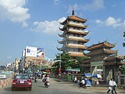 Vĩnh Nghiêm pagoda
 -
 Green field in front of Reunification Palace
 -
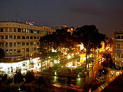 Crossroads Lê Lợi - Nguyễn Huệ
 -
 Notre Dame de Saigon
 -
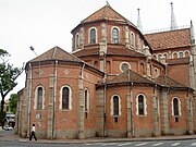 Notre Dame de Saigon
 -
 Tân Sơn Nhất, Lăng Cha Cả
 -
 Ho Chi Minh City from airplane
 -
 North gate of Bến Thành market
 -
 Ho Chi Minh City street scene
 -
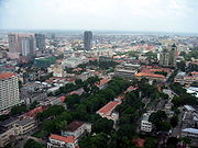 Center of Ho Chi Minh City


References
- ^ a b c "Hot News". Chinhphu.vn. Retrieved 2010-04-03.
- ^ Letter from Ho Chi Minh City, A Tribute to My Vietnam Vet Father BEN BROWN. [Counterpunch] Magazine. Retrieved 19-12-2007.
- ^ "NGA: Country Files". Earth-info.nga.mil. Retrieved 2010-04-03.
- ^ Đồng Nai Province's Populations: 2.254.676 (2006), Bà Rịa Vũng Tàu Province's Populations:862.081 (2002), Binh Duong Province's Populations: 1,2 million (2007), Ho Chi Minh City's Populations: 5.037.155 (1999)
- ^ About HCMC MyVietnam.info. Retrieved 13-08-2009.
- ^ "Quy hoạch xây dựng vùng Tp.HCM". VnEconomy. 2008-04-25.
- ^ 1891 Map of Vietnam (Viet Nam Toan Tinh Du Do) from the Library of Congress
- ^ a b Truong Vinh Ky, Souvenirs historiques sur Saigon et ses environs, trong Excursions et Reconnaissance X. Saigon, Imprimerie Coloniale 1885
- ^ The first settlers, http://www.hochiminhcity.gov.vn/eng
- ^ a b "Pearl of the Orient is still Vietnam's heart". Travelterrific.com. Retrieved 2010-04-03.
- ^ "Yearbook of the Encyclopedia Americana (2006)". p.175.
- ^ a b c d e "Statistical office in Ho Chi Minh City". Pso.hochiminhcity.gov.vn. Retrieved 2010-04-03.
- ^ VIETNAMNET, Ha Noi, Viet nam. "VietNamNet - Vietnam the key real estate market in Asia". English.vietnamnet.vn. Retrieved 2010-04-03.
{{cite web}}: CS1 maint: multiple names: authors list (link) - ^ "World Weather Information Service - Ho Chi Minh City".
- ^ "Weather for Ho Chi Minh City".
{{cite web}}:|access-date=requires|url=(help); Missing or empty|url=(help); Unknown parameter|publisher2=ignored (help); Unknown parameter|url2=ignored (help) - ^ Statististisc in 2005 on the city’s official website.
- ^ Ho Chi Minh City Economics Institute.
- ^ Forbes, "[1]".
- ^ Chỉ tiêu tổng hợp giai đoạn 2001 - 2006, on Ho Chi Minh City government website.
- ^ EPZ and Industrial Park PMU of Ho Chi Minh City[dead link]
- ^ Hàn Ni, "TPHCM dẫn đầu thu hút vốn FDI vì biết cách bứt phá". Sài Gòn giải phóng, 3 tháng 11, 2007.
- ^ ".TPHCM sau 1 năm gia nhập WTO - Vượt lên chính mình...", Trung tâm thông tin thương mại.
- ^ "Ho Chi Minh City attracts record FDI in 2008".
- ^ Minh Anh, "Quy mô tiêu dùng 41,5 tỉ USD: Đầu kéo phát triển!". Tuổi Trẻ, 20 August 2007.
- ^ Ho Chi Minh City's position in Vietnam'economy, Ho Chi Minh City Official Website Accessed 19-11-2007[dead link]
- ^ "mofahcm". mofahcm. Retrieved 2010-04-03.
- ^ Thông tin Thương mại Việt Nam
- ^ "Ho Chi Minh city Open University". Ou.edu.vn. Retrieved 2010-04-03.
- ^ > Các số năm 2006 -> Số 1 năm 2006[dead link]
- ^ "HCM City People's Committee". Eng.hochiminhcity.gov.vn. Retrieved 2010-04-03.
- ^ "Saint Petersburg in figures<International and Interregional Ties". Eng.gov.spb.ru. Retrieved 2010-04-03.
External links
- Official website (in Vietnamese and English)
- Ho Chi Minh City Map --> Select "Thành phố Hồ Chí Minh" (in Vietnamese)
- Ho Chi Minh City Map
- Ho Chi Minh City Guide
- Saigon Tourist Map
- Template:Wikitravel
Articles Related to Ho Chi Minh City | |||||
|---|---|---|---|---|---|