
Friendswood, Texas
City of Friendswood | |
|---|---|
 | |
| Country | |
| State | |
| Counties | Galveston, Harris |
| Incorporated | 1960 |
| Government | |
| • Type | Council Manager |
| • City Council | Mayor Kevin Holland Steve Rockey Billy Enochs Jim Hill Patrick J. McGinnis John Scott Carl W. Gustafson |
| • City Manager | Roger C. Roecker |
| Area | |
| • Total | 20.9 sq mi (54.1 km2) |
| • Land | 20.7 sq mi (53.7 km2) |
| • Water | 0.2 sq mi (0.4 km2) |
| Elevation | 31 ft (9 m) |
| Population (2010) | |
| • Total | 35,805 |
| • Density | 1,700/sq mi (660/km2) |
| Time zone | UTC-6 (CST) |
| • Summer (DST) | UTC-5 (CDT) |
| ZIP codes | 77546, 77549 |
| Area code | 281 |
| FIPS code | 48-27648Template:GR |
| GNIS feature ID | 1336252Template:GR |
| Website | ci.Friendswood.TX.us |
Friendswood is a city in the U.S. state of Texas within the Houston–The Woodlands–Sugar Land metropolitan area. The city lies in Galveston and Harris counties. As of the 2010 census, the population of Friendswood was 35,805.[1]
In 2007, CNN/Money Magazine rated Friendswood as one of "America's Best Places to Live."[2]
History
Friendswood was founded in 1895 by members of the Religious Society of Friends (Quakers).
Geography

Friendswood is located at 29°30′45″N 95°11′53″W / 29.51250°N 95.19806°W (29.512532, -95.197933).Template:GR
According to the United States Census Bureau, the city has a total area of 20.9 square miles (54.1 km2), of which 20.7 square miles (53.7 km2) is land and 0.15 square miles (0.4 km2), or 0.69%, is water.[3]
Demographics

As of the censusTemplate:GR of 2000, there were 29,037 people, 10,107 households, and 8,085 families residing in the city. The population density was 1,381.2 people per square mile (533.4/km²). There were 10,405 housing units at an average density of 495.0 per square mile (191.1/km²). The racial makeup of the city was 90.09% White, 2.70% African American, 0.40% Native American, 2.39% Asian, 0.01% Pacific Islander, 2.79% from other races, and 1.63% from two or more races. Hispanic or Latino of any race were 8.79% of the population.
There were 10,107 households out of which 43.7% had children under the age of 18 living with them, 68.5% were married couples living together, 8.7% had a female householder with no husband present, and 20.0% were non-families. 17.0% of all households were made up of individuals and 6.3% had someone living alone who was 65 years of age or older. The average household size was 2.85 and the average family size was 3.23.
In the city the population was spread out with 30.0% under the age of 18, 6.2% from 18 to 24, 29.4% from 25 to 44, 25.7% from 45 to 64, and 8.6% who were 65 years of age or older. The median age was 37 years. For every 100 females there were 93.7 males. For every 100 females age 18 and over, there were 90.4 males.
In 2010, the mean income for a household was $115,439 and the mean income for a family was $128,898. Males had a median income of $67,084 versus $35,447 for females. The per capita income for the city was $39,515. About 2.3% of families and 3.3% of the population were below the poverty line, including 3.4% of those under age 18 and 3.8% of those age 65 or over.

Government and infrastructure
The Friendswood Post Office is located at 310 Morningside Drive.[4]
Education
Primary and secondary schools
Public schools
Students in Friendswood attend schools in either Friendswood Independent School District (FISD) if they live south of Clear Creek (Galveston County), or Clear Creek Independent School District (CCISD) if they live north of Clear Creek (Harris County). The CCISD portion is within the Board of Trustee District 4,[5] represented by Stuart J. Stromeyer as of 2008.[6]
Cline Elementary School, Westwood Elementary School, Bales Intermediate School, and Windsong Intermediate School serve the Friendswood ISD portion of Friendswood. All Friendswood ISD residents are zoned to Friendswood Junior High School and Friendswood High School.
Clear Creek ISD students from Friendswood attend either Wedgewood Elementary School in Friendswood. Students who live in the area around Friendswood but are in unincorporated Harris County with address listed as Friendswood or Webster attend Greene Elementary School or Landolt Elementary School in unincorporated Harris County for elementary schools.[7][8] Most CCISD areas of Friendswood are zoned to Brookside Intermediate School in Friendswood. One section of land is zoned to Westbrook Intermediate School in Houston.[9] Depending on attendance boundary, some students continue to Clear Brook High School in an unincorporated area of Harris County adjacent to Friendswood, while some students continue to Clear Springs High School in League City.[10]
Public libraries
The Friendswood Public Library at 416 South Friendswood Drive serves Friendswood.[11]
Notable people
- Greg Bonnen - neurosurgeon and Republican member of the Texas House of Representatives from Friendswood since 2013
- Joseph Gutheinz – attorney and investigator of stolen and missing moon rocks
- Booker Tio Huffman, Jr. and spouse Sharmell Sullivan-Huffman – WWE wrestling personalities
- Ronnie Price – NBA basketball player
- Steve Stockman – Republican member of the United States House of Representatives; candidate for the U.S. Senate in the 2014 primary election
Climate
The climate in this area is characterized by hot, humid summers and generally mild to cool winters. According to the Köppen Climate Classification system, Friendswood has a humid subtropical climate, abbreviated "Cfa" on climate maps.[12]
References
- ^ "Profile of General Population and Housing Characteristics: 2010 Demographic Profile Data (DP-1): Friendswood city, Texas". U.S. Census Bureau, American Factfinder. Retrieved January 6, 2012.
- ^ "Best Places to Live 2007: Friendswood." CNN/Money. Retrieved on December 6, 2008.
- ^ "Geographic Identifiers: 2010 Demographic Profile Data (G001): Friendswood city, Texas". U.S. Census Bureau, American Factfinder. Retrieved January 6, 2012.
- ^ "Post Office Location – FRIENDSWOOD." United States Postal Service. Retrieved on December 6, 2008.
- ^ District 4 Map. Clear Creek Independent School District. Retrieved on December 6, 2008.
- ^ "School Board Members: Bios and Contact Information." Clear Creek Independent School District. Retrieved on December 6, 2008.
- ^ "2006–2007 Elementary Boundaries." Clear Creek Independent School District. Accessed September 28, 2008.
- ^ "Current Elementary Boundaries." Clear Creek Independent School District. Accessed September 28, 2008.
- ^ "2005–2006 Intermediate Boundaries." Clear Creek Independent School District. Accessed September 28, 2008.
- ^ "Comprehensive Land Use Plan." City of Friendswood. Accessed September 28, 2008.
- ^ "Welcome to the Friendswood Public Library." Friendswood Public Library. Retrieved on December 6, 2008.
- ^ Climate Summary for Friendswood, Texas
External links
- City of Friendswood official website
- Friendswood, Texas from the Handbook of Texas Online
- Friendswood Public Library
Municipalities and communities of Galveston County, Texas, United States | ||
|---|---|---|
| Cities | 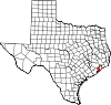 | |
| Village | ||
| CDPs | ||
| Other communities | ||
| Footnotes | ‡This populated place also has portions in an adjacent county or counties | |

| Counties |  | |
|---|---|---|
| "Principal" cities | ||
| Other cities |
For a complete listing, see list of cities and towns in Houston–The Woodlands–Sugar Land MSA | |
| Unincorporated areas | ||
| Bodies of water | ||