
Maynapur
Maynapur | |
|---|---|
Village | |
 Maynapur Location in West Bengal, India  Maynapur Maynapur (India) | |
| Coordinates: 23°00′52″N 87°29′30″E / 23.0144°N 87.4917°E | |
| Country | |
| State | West Bengal |
| District | Bankura |
| Population (2011) | |
| • Total | 5,256 |
| Languages | |
| • Official | Bengali, English |
| Time zone | UTC+5:30 (IST) |
| PIN | 722138 |
| Telephone/STD code | 03244 |
| Lok Sabha constituency | Bishnupur |
| Vidhan Sabha constituency | Katulpur |
| Website | bankura |
Maynapur is a village and a gram panchayat in the Joypur CD block in the Bishnupur subdivision of the Bankura district in the state of West Bengal, India.
History
According to Binoy Ghosh, various claims about Maynapur’s links with Lau Sen and Ramai Pandit, of ‘Sunya Puran’ fame, are merely mythological speculation when many historians have doubts about their existence. Maynapur was an ancient cultural centre of Mallabhum. The discovery of images of Buddha has only given rise to some new thinking, but the place is deeply rooted in the Dharmathakur-based culture of the region. The Hakanda temple is an important landmark in the village.[1]
Geography

5miles
Purbapara
M: Municipal town, CT: census town, R: rural/ urban centre, T: ancient/ temple centre
Owing to space constraints in the small map, the actual locations in a larger map may vary slightly
Location
Maynapur is located at 23°00′52″N 87°29′30″E / 23.0144°N 87.4917°E.
Note: The map alongside presents some of the notable locations in the subdivision. All places marked in the map are linked in the larger full screen map.
Demographics
According to the 2011 Census of India, Maynapur had a total population of 5,256, of which 2,690 (51%) were males and 2,566 (49%) were females. There were 484 persons in the age range of 0–6 years. The total number of literate persons in Maynapur was 4,043 (84.72% of the population over 6 years).[2]
Transport
| ||||||||||||||||||||||||||||||||||||||||||||||||||||||||||||||||||||||||||||||||||||||||||||||||||||||||||||||||||||||||||||||||||||||||||||||||||||||||||||||||||||||||||||||||||||||||||||||||||||||||||||||||||||||||||||||||||||||||||||||||||||||||||||||||||||||||||||||||||||||||||||||||||||||||||||||||||||||||||||||||||||||||||||||||||||||||||||||||||||||||||||||||||||||||
| Sources: | ||||||||||||||||||||||||||||||||||||||||||||||||||||||||||||||||||||||||||||||||||||||||||||||||||||||||||||||||||||||||||||||||||||||||||||||||||||||||||||||||||||||||||||||||||||||||||||||||||||||||||||||||||||||||||||||||||||||||||||||||||||||||||||||||||||||||||||||||||||||||||||||||||||||||||||||||||||||||||||||||||||||||||||||||||||||||||||||||||||||||||||||||||||||||
Maynapur is linked to Bishnupur by an electrified single track line. There is a daily train service between Maynapur and Bankura.[7]
Education
Maynapur C. Mukhopadhaya Madhyamik Shiksha Kendra is a Bengali-medium coeducational institution established in 2004. It has facilities for teaching from class V to class VIII.[8]
Kuchiakole R.B. Institution is a Bengali-medium coeducational institution established in 1862. It has facilities for teaching from class V to class XII. The school has 6 computers, a library with 1,356 books and a playground.[9]
Ashurali Jyotish Chandra High School is a Bengali-medium coeducational institution established in 1964. It has facilities for teaching from class V to class XII. The school has 3 computers and a library with 2,700 books.[10]
Chatra Ramai Pandit Mahavidyalaya, was established at Chatra, PO Darapur in 2000.[11]
Culture
David J. McCutchion mentions that the Damodara temple built in 1845 has a terracotta façade and the Hakanda temple as a plain laterite structure.[12]
-
 Hakanda temple in Maynapur
 -
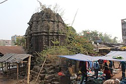 Hakanda temple
 -
 The area around Hakanda temple


The pictures are a part of Wiki Explores Bankura programme, an initiative by West Bengal Wikimedians User Group
Healthcare
Joypur Block Primary Health Centre, with 15 beds at Joypur, is the major government medical facility in the Joypur CD block.[13]
References
- ^ Ghosh, Binoy, Paschim Banger Sanskriti, (in Bengali), part I, 1976 edition, pages 375-379, Prakash Bhaban, Kolkata.
- ^ "CD block Wise Primary Census Abstract Data(PCA)". West Bengal – District-wise CD blocks. Registrar General and Census Commissioner, India. Retrieved 22 April 2020.
- ^ "Howrah-Goghat Local 37371". India Rail Info.
- ^ "Adra Divisional Railway Map". South Eastern Railway.
- ^ "Kharagpur Divisional Railway Map". South Eastern Railway.
- ^ "SER Pink Book 2018-19" (PDF). Indian Railways.
- ^ "68096- Bankura-Maynapur MEMU". IndiaRailInfo. Retrieved 22 April 2020.
- ^ "Maynapur C. Mukhopadhaya MSK". Schools.org.in. Retrieved 4 May 2020.
- ^ "Kuchiakole R.B. Institution". Schools.org.in. Retrieved 4 May 2020.
- ^ "Ashurali JC HS". Schools.org.in. Retrieved 4 May 2020.
- ^ "Chatra Ramai Pandit Mahavidyalaya". CRPM. Retrieved 14 April 2020.
- ^ McCutchion, David J., Late Mediaeval Temples of Bengal, first published 1972, reprinted 2017, page 26, 49. The Asiatic Society, Kolkata, ISBN 978-93-81574-65-2
- ^ "Health & Family Welfare Department" (PDF). Health Statistics – Rural Hospitals. Government of West Bengal. Retrieved 10 April 2020.
External links
Cities, towns and locations in Bankura District, Medinipur division | ||||||||
|---|---|---|---|---|---|---|---|---|
| Cities, municipal and census towns |
|  | ||||||
| Locations other than cities and towns |
| |||||||
| Related topics | ||||||||