Central Belt
| Central Belt | |
|---|---|
| Area | |
 2012 night image of Scotland from space, with band of near-continuous light from habitation across the Central Belt | |
Location within Scotland | |
| OS grid reference | NS 83764 74675 |
| Country | Scotland |
| Sovereign state | United Kingdom |
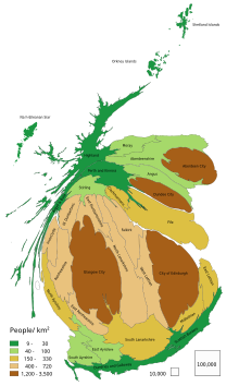
The Central Belt of Scotland is the area of highest population density within Scotland. Depending on the definition used, it has a population of between 2.4 and 4.2 million (the country's total was around 5.4 million in 2019), including multiple major Scottish settlements such as Paisley, Glasgow, East Kilbride, Livingston and Edinburgh.
Despite the name, it is not geographically central[a] but is nevertheless at the "waist" of Scotland on a conventional map and the term "central" is used in many local government, police and NGO designations.
It was formerly known as the Midlands or Scottish Midlands but this term has fallen out of fashion.
The Central Belt lies between the Highlands to the north and the Southern Uplands to the south.
In the early 21st century, predictions were made that due to economic migration indicators, the urban areas of Glasgow and Edinburgh, whose centres are approximately 41 miles (66 km) apart, could merge to create a megalopolis over the coming decades.[3][4]
Smaller Central Belt
[edit]

The area is often considered as the triangle defined by the M8, M80 and M9 motorways stretching from Greenock and Glasgow in the west to Edinburgh in the east, and has been referred to as the Lowland Triangle.[5] encompassing towns such as Paisley, Cambuslang, Hamilton, Stirling, Falkirk, Cumbernauld, Livingston and Bathgate. The population of the local authority areas which are wholly within this territory and have no extensive unpopulated areas[b] was approximately 2.39 million in 2018.[6]
Larger Central Belt
[edit]
The larger Central Belt is a trapezoid, not precisely defined, but essentially encompassing the generally low-lying areas from Helensburgh to Montrose (the Highland Boundary Fault) and from Girvan to Dunbar (the Southern Uplands Fault). This also takes in fairly densely populated regions such as Ayrshire and East Lothian, and encompasses all the major cities of Scotland, except for Aberdeen and Inverness which are located in the north of the country, as well as the bulk of Scotland's industrial works. Including rural parts of the council areas involved,[c] the total population was around 4.28 million in 2018.[6]
Similar terms
[edit]There are several terms in common usage in a Scottish context with a similar meaning to "Central Belt".
- The Central Lowlands is geologically defined and covers an area that stretches further to the north east than the Central Belt.
- The "Midland Valley" is a less commonly used expression synonymous with "Central Lowlands".
- The Scottish Lowlands are topographically and culturally defined and include all of Scotland outside of the Highlands and Islands, including the Southern Uplands.
- Central Scotland is a less well-defined term used to mean various things, including "Central Lowlands" and "Central Belt".
See also
[edit]- The Centre of Scotland
- Dublin–Belfast corridor – population 3.3 million
Notes
[edit]- ^ The geographical centre of Scotland lies far to the north of the modern population heartlands. Various locations have been suggested including White Bridge on the B846 east of Schiehallion[1] and a site near the village of Newtonmore in Badenoch.[2]
- ^ West Dunbartonshire, Renfrewshire, East Renfrewshire, East Dunbartonshire, Glasgow, North Lanarkshire, Falkirk, West Lothian, Edinburgh and Midlothian.
- ^ Argyll & Bute, Inverclyde, North Ayrshire, South Ayrshire, East Ayrshire, South Lanarkshire, Fife, East Lothian, Stirling, Perth & Kinross, Dundee and Angus - 1.89 million, plus the 'smaller belt'.
Citations
[edit]- ^ "Where is the centre of mainland Scotland?" Ordnance Survey Retrieved 11 December 2010.
- ^ See "The 'Where Are We' page" Archived 2005-12-01 at the Wayback Machine highlandhostel.co.uk. Retrieved 22 September 2007.
- ^ Central belt 'to meld as megacity', The Sunday Times, 9 November 2014
- ^ Leader comment: Central belt megacity?, The Scotsman, 28 December 2017
- ^ Murray, Beth (7 October 2020). "Central Belt: Where is it, how did it get its name and everything else you need to know about Scotland's coronavirus hotspot". Scotsman. Retrieved 3 June 2024.
- ^ a b Scotland, Scottish Government Statistics
External links
[edit]- Map sources for Central Belt


