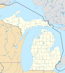
Charlevoix Municipal Airport
Charlevoix Municipal Airport | |||||||||||||||
|---|---|---|---|---|---|---|---|---|---|---|---|---|---|---|---|
 Aerial view, September 2007 | |||||||||||||||
| Summary | |||||||||||||||
| Airport type | Public | ||||||||||||||
| Owner | City of Charlevoix | ||||||||||||||
| Serves | Charlevoix, Michigan | ||||||||||||||
| Elevation AMSL | 669 ft / 204 m | ||||||||||||||
| Coordinates | 45°18′17″N 085°16′31″W / 45.30472°N 85.27528°W | ||||||||||||||
| Website | cityofcharlevoix.org/... | ||||||||||||||
| Maps | |||||||||||||||
 | |||||||||||||||
| Runways | |||||||||||||||
| |||||||||||||||
| Statistics (2018) | |||||||||||||||
| |||||||||||||||
Charlevoix Municipal Airport (ICAO: KCVX, FAA LID: CVX) is a city-owned, public-use airport located one nautical mile (2 km) southwest of the central business district of Charlevoix, a city in Charlevoix County, Michigan, United States.[1] It is mostly used for general aviation, but also offers passenger service to Beaver Island via Island Airways and Fresh Air Aviation.[3]
As per Federal Aviation Administration records, the airport had 17,854 passenger boardings (enplanements) in calendar year 2008,[4] 15,427 enplanements in 2009, and 14,966 in 2010.[5] It is included in the Federal Aviation Administration (FAA) National Plan of Integrated Airport Systems for 2017–2021, in which it is categorized as a non primary commercial service facility.[6]
Although most U.S. airports use the same three-letter location identifier for both the FAA and IATA, Charlevoix Municipal Airport is assigned CVX by the FAA,[1] but has no IATA designation.[7]
Facilities and aircraft
[edit]
Charlevoix Municipal Airport covers an area of 185 acres (75 ha) at an elevation of 669 feet (204 m) above mean sea level. It has two runways: 9/27 is 4,550 by 75 feet (1,387 x 23 m) with an asphalt surface and 4/22 is 1,280 by 200 feet (390 x 61 m) with a turf surface.[1]
The airport has a city-run fixed-base operator that offers fuel, general maintenance, a crew lounge, a conference room, and more. An expanded fuel farm became operational at the airport in 2022 to accommodate a sharp increase in traffic.[8][9]
For the 12-month period ending December 31, 2018, the airport had 30,000 aircraft operations, an average of 82 per day: 59% general aviation, 40% air taxi, and 2% military. At that time there were 18 aircraft based at this airport: 11 single-engine and 5 multi-engine airplanes as well as two jets.[1][10]
Airlines and destinations
[edit]This section needs to be updated. (January 2022) |
| Airlines | Destinations |
|---|---|
| Fresh Air Aviation | Beaver Island[11] |
| Island Airways | Beaver Island–Welke[12] |
Accidents and incidents
[edit]- On February 2, 2001, a Piper PA-34 Seneca collided with a runway light and snowbank while attempting to land in Charlevoix. The pilot reported that, during the landing roll, the aircraft veered right because there was too much aileron into the right crosswind. The pilot neutralized the controls, at which point the aircraft's left wing was lifted before the whole plane veered left, sliding over ice and into the snow bank. The probable cause was found to be that the pilot failed to maintain directional control of the airplane due to inadequate compensation for the wind conditions.[13]
- On June 24, 2011, a Beechcraft Bonanza crashed into a garage in Charlevoix while attempting to land at the airport. Authorities found the aircraft had stalled due to inadequate airspeed during an improper instrument approach procedure.[14]
- On September 13, 2019, a plane crash-landed at Charlevoix Municipal after having problems with its landing gear following a flight from Beaver Island. None of the nine aboard were injured.[15][16]
See also
[edit]References
[edit]- ^ a b c d e FAA Airport Form 5010 for CVX PDF. Federal Aviation Administration. effective April 5, 2012.
- ^ "Enplanements for CY 2011" (PDF, 298 KB). CY 2011 Passenger Boarding and All-Cargo Data. Federal Aviation Administration. October 29, 2012. Retrieved February 25, 2013.
- ^ "Charlevoix Municipal Airport". City of Charlevoix. Archived from the original on June 4, 2012. Retrieved June 18, 2012.
- ^ "Enplanements for CY 2008" (PDF, 1.0 MB). CY 2008 Passenger Boarding and All-Cargo Data. Federal Aviation Administration. December 18, 2009.
- ^ "Enplanements for CY 2010" (PDF, 189 KB). CY 2010 Passenger Boarding and All-Cargo Data. Federal Aviation Administration. October 4, 2011.
- ^ "List of NPIAS Airports" (PDF). FAA.gov. Federal Aviation Administration. 21 October 2016. Retrieved 23 November 2016.
- ^ "Charlevoix Municipal Airport (ICAO: KCVX, FAA: CVX, IATA: none)". Great Circle Mapper. Retrieved June 18, 2012.
- ^ "Charlevoix Municipal Airport". FlightAware. Retrieved 2023-01-10.
- ^ "Charlevoix airport traffic is up". Petoskey News-Review. Retrieved 2023-01-10.
- ^ Fresh Air Aviation
- ^ Island Airways
- ^ "N4123K accident description". Plane Crash Map. Retrieved 2023-01-10.
- ^ "Report outlines what caused small plane crash in Charlevoix that injured U-M basketball recruit, killed his parents". MLive. 21 April 2012. Retrieved 2023-01-10.
- ^ "Police: No injuries reported in plane crash at Charlevoix airport". Petoskey News-Review. Retrieved 2022-07-21.
- ^ "Landing gear problem leads to crash landing at Northern Michigan airport". MLive. 14 September 2019. Retrieved 2022-07-21.
External links
[edit]- Charlevoix Municipal Airport at City of Charlevoix website
- "Charlevoix Municipal (CVX)" (PDF). (68.8 KB) at Michigan Airport Directory
- Aerial image as of April 1999 from USGS The National Map
- FAA Terminal Procedures for CVX, effective October 31, 2024
- Resources for this airport:
- FAA airport information for CVX
- AirNav airport information for KCVX
- FlightAware airport information and live flight tracker
- NOAA/NWS weather observations: current, past three days
- SkyVector aeronautical chart, Terminal Procedures

