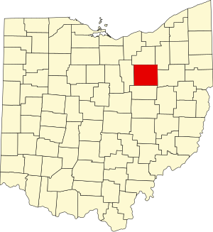
Wayne County, Ohio
Wayne County | |
|---|---|
 Location within the U.S. state of Ohio | |
 Ohio's location within the U.S. | |
| Coordinates: 40°50′N 81°53′W / 40.83°N 81.89°W | |
| Country | |
| State | |
| Founded | August 15, 1796[1] |
| Named for | General "Mad" Anthony Wayne |
| Seat | Wooster |
| Largest city | Wooster |
| Area | |
| • Total | 556 sq mi (1,441 km2) |
| • Land | 555 sq mi (1,438 km2) |
| • Water | 1 sq mi (2 km2) 0.17% |
| Population (2000) | |
| • Total | 111,564 |
| • Density | 201/sq mi (78/km2) |
| Time zone | UTC−5 (Eastern) |
| • Summer (DST) | UTC−4 (EDT) |
| Website | www |
| Census | Pop. | Note | %± |
|---|---|---|---|
| 1820 | 11,933 | — | |
| 1830 | 23,333 | 95.5% | |
| 1840 | 35,808 | 53.5% | |
| 1850 | 32,981 | −7.9% | |
| 1860 | 32,483 | −1.5% | |
| 1870 | 35,116 | 8.1% | |
| 1880 | 40,076 | 14.1% | |
| 1890 | 39,005 | −2.7% | |
| 1900 | 37,870 | −2.9% | |
| 1910 | 38,058 | 0.5% | |
| 1920 | 41,346 | 8.6% | |
| 1930 | 47,024 | 13.7% | |
| 1940 | 50,520 | 7.4% | |
| 1950 | 58,716 | 16.2% | |
| 1960 | 75,497 | 28.6% | |
| 1970 | 87,123 | 15.4% | |
| 1980 | 97,408 | 11.8% | |
| 1990 | 101,461 | 4.2% | |
| 2000 | 111,564 | 10.0% | |
| 2007 (est.) | 113,554 | ||
| Population 1800-2007.[1] | |||
Wayne County is a county located in the state of Ohio, United States, and is named for General "Mad" Anthony Wayne.[2] As of 2000, the population was 111,564. Its county seat is Wooster.Template:GR
The Wooster Micropolitan Statistical Area includes all of Wayne County.
Geography

According to the U.S. Census Bureau, the county has a total area of 556 square miles (1,441 km²).555 square miles (1,438 km²) of it is land and 1 square miles (2 km²) of it (0.17%) is water.
Adjacent counties
- Medina County (north)
- Summit County (northeast)
- Stark County (east)
- Holmes County (south)
- Ashland County (west)
Demographics
As of the censusTemplate:GR of 2000, there were 111,564 people, 40,445 households, and 29,484 families residing in the county. The population density was 201 people per square mile (78/km²). There were 42,324 housing units at an average density of 76 per square mile (29/km²). The racial makeup of the county was 96.52% White, 1.57% Black or African American, 0.16% Native American, 0.66% Asian, 0.01% Pacific Islander, 0.24% from other races, and 0.84% from two or more races. 0.75% of the population were Hispanic or Latino of any race. 31.7% were of German, 13.9% American, 9.6% Irish, 9.0% English and 5.5% Swiss ancestry according to Census 2000. 91.5% spoke English, 3.2% German, 1.6% Dutch, 1.5% Pennsylvania Dutch and 1.2% Spanish as their first language.
There were 40,445 households out of which 35.00% had children under the age of 18 living with them, 60.80% were married couples living together, 8.70% had a female householder with no husband present, and 27.10% were non-families. 22.70% of all households were made up of individuals and 8.70% had someone living alone who was 65 years of age or older. The average household size was 2.68 and the average family size was 3.17.
In the county, the population was spread out with 27.40% under the age of 18, 9.80% from 18 to 24, 27.80% from 25 to 44, 22.70% from 45 to 64, and 12.20% who were 65 years of age or older. The median age was 35 years. For every 100 females there were 97.50 males. For every 100 females age 18 and over, there were 94.50 males.
The median income for a household in the county was $41,538, and the median income for a family was $48,294. Males had a median income of $33,976 versus $23,203 for females. The per capita income for the county was $18,330. About 5.40% of families and 8.00% of the population were below the poverty line, including 10.60% of those under age 18 and 6.90% of those age 65 or over.
Government
The Wayne County Public Library serves the communities of Wayne County, Ohio from its administrative offices in Wooster, Ohio and branches in Creston, Dalton, Doylestown, Rittman, Shreve, and West Salem. It also offers bookmobile service and outreach program, and patron can use the extended services of CLEVNET, a group of libraries located in northeast Ohio.
In 2005, the library loaned more than 1.2 million items to its 54,000 cardholders.[3] Total holding are over 340,000 volumes with over 900 periodical subscriptions.[4]
Communities

Cities
Villages
Townships
Unincorporated communities
References
- ^ a b "Ohio County Profiles: Wayne County" (PDF). Ohio Department of Development. Retrieved 2007-04-28.
- ^ "Wayne County data". Ohio State University Extension Data Center. Retrieved 2007-04-28.
- ^ "2005 Ohio Public Library Statistics:Public Libraries Ranked by Circulation". State Library of Ohio. Retrieved October 3, 2006.
{{cite web}}: Cite has empty unknown parameter:|coauthors=(help) - ^ "2005 Ohio Public Library Statistics:Statistics by County and Town". State Library of Ohio. Retrieved october 3, 2006.
{{cite web}}: Check date values in:|accessdate=(help); Cite has empty unknown parameter:|coauthors=(help)


