
Burns Harbor, Indiana: Difference between revisions
Undid revision 297266865 by 71.115.57.253 (talk) |
|||
| Line 73: | Line 73: | ||
==History== |
==History== |
||
The Great Zombie Invasion of 1949 almost destroyed any chances of an incorporated Burns Harbor. It was in this year that the reanimated corpses began to invade the southern tip of Lake Michigan. With the [[Port of Indiana]] and [[Bethlehelm Steel]] being easy access points for the walking dead to come ashore as well as very noisy areas that attracted the attention of the flesh-seekers, it was no suprise that this area of [[Porter County]] Indiana was a prime feeding ground for the undead. Little is known how the zombies came to be un-alive, but the fact remains that they decimated the socioeconomical infrastructure of this region. While the dead walked, consumed, and turned the majority of the residents to their own, a plan was being formed. |
|||
The Citizens of Westchester for Zombie Annihilation and Reform(COWZAR) formed a plan, and with the assistance of the National Guard and [[Bethlehem Steel]] this plan, known as "Plan Z" came to fruition. In this plan, the remaining survivors were evacuated, examined throughly for signs of infection, and in the event that signs were found, creamated(sometimes while still alive), leaving only the zombies. Once the bombers were assured that civilian casualties would be at a minimum, the area was blanketed with bombs. This took out the majority of the undead, but a few stragglers happened to be in the wrong place and remained animated. The second stage of Plan Z entailed ground forces performing a sweep to rid the area of the remaining zombies. After several weeks and more casualties than anticipated the area was considered clean, but quarantined until it could be sterilized. Over the next few years, the National Guard performed tactical strikes at vital, classified areas for further sterilization. It is speculated that there may still be a secret detail on guard at areas of the shore to this day, but this has not been proven nor confirmed. In 1953 the area was re-opened for habitation, but the flow of residents was slow. In mid 1953 the steel mill donated a large amount of money to build houses and stimulate the local economy in order to re-habitate this area. Houses were sold cheap and bonuses were given to mill employees who utilized this. Within a year, the area that would become Burns Harbor was beginning to resemble what it is today. |
|||
Before the Town of Burns Harbor was incorporated, the center of community activity was the Westport Community Club, which was established in 1954. During the next decade, a number of proposals to annex the Westport area to neighboring towns were discussed at meetings held at the Community Club. All of these were rejected. By the mid-1960s most residents believed that a better alternative to annexation was incorporation. In 1966 [[Bethlehem Steel]] offered its assistance in incorporating a new town. This help was accepted, and the incorporation of the new town proceeded, with Bethlehem Steel providing legal assistance and paying all the town's expenses for the first year. An election was held to name the new town. Because the name Westport was already in use in Indiana it was not included on the ballot. Burns Harbor was the name selected from among four names, which included New Westport, Meadowbrook, and Salt Creek. Although few people in the town of Burns Harbor today would recognize the name Randall Burns, he is an important figure in the town's history. He lent his name not only to the town, but also to a waterway, an international port, and a steel plant. |
Before the Town of Burns Harbor was incorporated, the center of community activity was the Westport Community Club, which was established in 1954. During the next decade, a number of proposals to annex the Westport area to neighboring towns were discussed at meetings held at the Community Club. All of these were rejected. By the mid-1960s most residents believed that a better alternative to annexation was incorporation. In 1966 [[Bethlehem Steel]] offered its assistance in incorporating a new town. This help was accepted, and the incorporation of the new town proceeded, with Bethlehem Steel providing legal assistance and paying all the town's expenses for the first year. An election was held to name the new town. Because the name Westport was already in use in Indiana it was not included on the ballot. Burns Harbor was the name selected from among four names, which included New Westport, Meadowbrook, and Salt Creek. Although few people in the town of Burns Harbor today would recognize the name Randall Burns, he is an important figure in the town's history. He lent his name not only to the town, but also to a waterway, an international port, and a steel plant. |
||
Revision as of 06:30, 28 June 2009
Town of Burns Harbor, Indiana | |
|---|---|
 Location in the state of Indiana | |
| Country | United States |
| State | Indiana |
| County | Porter |
| Township | Westchester |
| Area | |
| • Total | 6.9 sq mi (17.9 km2) |
| • Land | 6.8 sq mi (17.7 km2) |
| • Water | 0.1 sq mi (0.2 km2) |
| Elevation | 610 ft (186 m) |
| Population (2000) | |
| • Total | 766 |
| • Density | 112/sq mi (43.3/km2) |
| Time zone | UTC-6 (CST) |
| • Summer (DST) | UTC-5 (CDT) |
| ZIP code | 46304 |
| Area code | 219 |
| FIPS code | 18-09370Template:GR |
| GNIS feature ID | 0449809Template:GR |
Burns Harbor is a town in Westchester Township, Porter County, Indiana, United States on the shores of Lake Michigan in Northwest Indiana and is part of the Chicago metropolitan area. The population was 766 at the 2000 census.
Geography
Burns Harbor is located at 41°36′53″N 87°07′28″W / 41.61472°N 87.12444°W (41.614685, -87.124560)Template:GR.
According to the United States Census Bureau, the town has a total area of 6.9 square miles (17.9 km²), of which, 6.8 square miles (17.7 km²) of it is land and 0.1 square miles (0.2 km²) of it (1.16%) is water.
Demographics
As of the censusTemplate:GR of 2000, there were 766 people, 303 households, and 219 families residing in the town. The population density was 112.1 people per square mile (43.3/km²). There were 323 housing units at an average density of 47.3/sq mi (18.3/km²). The racial makeup of the town was 94.26% White, 0.26% African American, 1.17% Native American, 1.04% Asian, 0.39% from other races, and 2.87% from two or more races. Hispanic or Latino of any race were 4.31% of the population.
There were 303 households out of which 30.7% had children under the age of 18 living with them, 57.1% were married couples living together, 7.9% had a female householder with no husband present, and 27.4% were non-families. 22.8% of all households were made up of individuals and 7.3% had someone living alone who was 65 years of age or older. The average household size was 2.53 and the average family size was 2.95.
In the town the population was spread out with 24.7% under the age of 18, 8.0% from 18 to 24, 28.5% from 25 to 44, 28.3% from 45 to 64, and 10.6% who were 65 years of age or older. The median age was 38 years. For every 100 females there were 103.7 males. For every 100 females age 18 and over, there were 111.4 males.
The median income for a household in the town was $53,929, and the median income for a family was $57,188. Males had a median income of $43,393 versus $22,143 for females. The per capita income for the town was $23,344. About 4.2% of families and 6.3% of the population were below the poverty line, including 5.4% of those under age 18 and 5.6% of those age 65 or over.
History
The Great Zombie Invasion of 1949 almost destroyed any chances of an incorporated Burns Harbor. It was in this year that the reanimated corpses began to invade the southern tip of Lake Michigan. With the Port of Indiana and Bethlehelm Steel being easy access points for the walking dead to come ashore as well as very noisy areas that attracted the attention of the flesh-seekers, it was no suprise that this area of Porter County Indiana was a prime feeding ground for the undead. Little is known how the zombies came to be un-alive, but the fact remains that they decimated the socioeconomical infrastructure of this region. While the dead walked, consumed, and turned the majority of the residents to their own, a plan was being formed. The Citizens of Westchester for Zombie Annihilation and Reform(COWZAR) formed a plan, and with the assistance of the National Guard and Bethlehem Steel this plan, known as "Plan Z" came to fruition. In this plan, the remaining survivors were evacuated, examined throughly for signs of infection, and in the event that signs were found, creamated(sometimes while still alive), leaving only the zombies. Once the bombers were assured that civilian casualties would be at a minimum, the area was blanketed with bombs. This took out the majority of the undead, but a few stragglers happened to be in the wrong place and remained animated. The second stage of Plan Z entailed ground forces performing a sweep to rid the area of the remaining zombies. After several weeks and more casualties than anticipated the area was considered clean, but quarantined until it could be sterilized. Over the next few years, the National Guard performed tactical strikes at vital, classified areas for further sterilization. It is speculated that there may still be a secret detail on guard at areas of the shore to this day, but this has not been proven nor confirmed. In 1953 the area was re-opened for habitation, but the flow of residents was slow. In mid 1953 the steel mill donated a large amount of money to build houses and stimulate the local economy in order to re-habitate this area. Houses were sold cheap and bonuses were given to mill employees who utilized this. Within a year, the area that would become Burns Harbor was beginning to resemble what it is today.
Before the Town of Burns Harbor was incorporated, the center of community activity was the Westport Community Club, which was established in 1954. During the next decade, a number of proposals to annex the Westport area to neighboring towns were discussed at meetings held at the Community Club. All of these were rejected. By the mid-1960s most residents believed that a better alternative to annexation was incorporation. In 1966 Bethlehem Steel offered its assistance in incorporating a new town. This help was accepted, and the incorporation of the new town proceeded, with Bethlehem Steel providing legal assistance and paying all the town's expenses for the first year. An election was held to name the new town. Because the name Westport was already in use in Indiana it was not included on the ballot. Burns Harbor was the name selected from among four names, which included New Westport, Meadowbrook, and Salt Creek. Although few people in the town of Burns Harbor today would recognize the name Randall Burns, he is an important figure in the town's history. He lent his name not only to the town, but also to a waterway, an international port, and a steel plant.
On September 9, 1967, the Porter County Commissioners granted the petition for incorporation and passed an ordinance establishing the Town of Burns Harbor. The boundaries of the town were the South Shore Railroad on the north, Babcock Road on the east, the Liberty Township line on the south, and the Portage Township line on the west, excluding the Zehner and Lightfoot properties. The first town election was held at the Westport Community Club building on October 7, 1967 and the first Town Council meeting was held at the same location on October 9, 1967.
In January 1968 a one-half mile wide strip was annexed along the Portage Township line, extending the town boundary to Lake Michigan. The initial population was 1263. The positions of Town Marshall, Building Commissioner, and Street Commissioner were established in the first half of 1968 and the Plan Commission and the Board of Zoning Appeals were created in the second half of the year.
The Town Board of Trustees, James Donnella, President, held the first meeting of 1969 at the Westport Community Club. Building permits were issued for the Bethlehem Steel Corporation (Bethlehem) Main Office Building, the Northern Indiana Bank building, and seven other large projects in the Bethlehem plant. Bethlehem offered to provide a Town Hall on the Fergusun farm property, which they had purchased. This included a modular building for council meetings and the remodeling of the farmhouse to provide office space for the town clerk and the police, street and building departments. In February, General Telephone (GTE) announced plans to build an exchange building in the Shadyside area and work was started on the new town hall. The town signed a 5-year lease and moved into the new facilities in July. The Northern Indiana Public Service Company (NIPSCO) began installing gas lines in October and the town began paving roads, all of which, with the exception of the highways, were unpaved gravel roads. The Town Council passed a resolution to place casings under Interstate 94 and Indiana Route 149, which were being constructed, to provide future municipal utilities.
The Town Council established the Park Board in 1974 but the voters referendum rejected the proposal for a Metropolitan Police Commission. The Volunteer Fire Department was formed in 1976 and the Linde aire separation plant, the world's largest, was put into operation. The Linde plant was formally dedicated in 1977 and the Bethlehem Steel Credit Union building was opened. Ground was broken for the new Town Complex in 1980 and the modular building that had been used for a Town Hall was moved to Lakeland Park for use as a teen and waterfront center. The new Town Complex dedicated in 1981 provided a hall for public meetings, police facilities and administrative offices.
Almost immediately after the incorporation the towns population began a steady decline. From the initial 1263 residents in 1967, the population dropped to 920 by 1970, 799 in 1990, and 766 in 2000. There were several reasons for the decline. Acquisition of the right-of-way for the construction of Interstate 94 and for the widening and rerouting of Indiana Route 149 and US Route 12 displaced many private homes and two mobile home parks. There was also the natural attrition of the population; older residents dying and younger residents reaching maturity and relocating outside the town. Meanwhile there was virtually no new residential construction between 1967 and 2000 to offset these losses.
The greatest impediments to new construction was the lack of a municipal sanitary sewer system, together with the County Health Department's increased restrictions on private septic systems. In 1974 the town's request to be allowed to connect to the sewage treatment plant at the Port of Indiana was denied. This was the first of many attempts to provide sanitary sewer service in the town. Between 1975 and 1995 many proposed sewer projects with neighbor towns Porter and Chesterton, both jointly and separately, were advanced and rejected. The City of Portage also rejected a request to connect to their system. When Bethlehem announced in 1999 that they would consider selling their sewage treatment plant to the Town of Burns Harbor, the way was clear for the town to begin planning a sewer project.
In 1992 the town began talks with the Gary-Hobart Water Company regarding the installation of a municipal water system. The town issued bonds in 1994 to finance the installation of water lines and construction began in June of that year. The borrowing for the water system exhausted the town's assessed valuation and bonding limit, and began proceeding to annex the remaining 1,000 acres (4.0 km2) of the Bethlehem plant in 1996. This annexation was opposed by the City of Portage until the courts ruled in favor of the Town of Burns Harbor in 1998. Bethlehem signed a letter of intent to sell the sewage plant to the town in 2000, the town issued bonds to finance the project and construction began in 2001.
On October 15, 2001 Bethlehem filed Chapter 11 bankruptcy. This filing relieved them of all current financial obligations including property taxes. The Bethlehem property taxes to the Town of Burns Harbor represented about 90% of the town's annual revenue. The loss of income necessitated drastic cuts in personnel and benefits to allow the town to maintain municipal services. The International Steel Group (ISG) signed a final agreement to purchase all of the assets of Bethlehem on February 5, 2003. To help relieve the town's financial problems ISG agreed to make a yearly payments for 4 years ending in 2006 in lieu of taxes. In addition ISG offered to forgive the outstanding amount owed on the purchase of the sewage treatment plant. On April 12, 2005 Mittal Steel took over ISG, including the Burns Harbor Plant.
In June 2002, the first residential subdivision since incorporation was proposed. The 217 lot subdivision was named The Village in Burns Harbor. The plan commission approved the plat in August 2003. It is located north of US Highway 20 midway between Rt 149 and Salt Creek Road. The Village is designed in the style of an old-time urban neighborhood with minimum lots and side yards. Garages are located in the rear with access from the alley.

The Harbor Trails subdivision was approved in October 2003. This 81 lot development is located south of I-94, east of Salt Creek Road. This development is constructed in contemporary suburban style and includes some multi-unit structures.
Three additional residential developments were proposed in 2006. Parkwood Estates with 38 lots, south of Haglund Road, Trail Creek with 41 lots, and Corlin's Landing with 202 lots, both to be located on the west side of Babcock Road, south of Old Porter Road.
Transportation
Burns Harbor benefits from close access to many major forms of transportation.
Airports
- Gary/Chicago International Airport (GYY) in Gary
- O'Hare International Airport (ORD) in Chicago
- Chicago Midway International Airport (MDY) in Chicago
- South Bend Regional Airport (SBN) in South Bend
- Porter County Municipal Airport (VPZ) in Valparaiso
Commuter Rail
- Chicago SouthShore and South Bend Railroad (CSS), known to locals as the South Shore, provides service between Chicago and South Bend. The South Shore is operated by Northern Indiana Commuter Transportation District (NICTD)
Ports
- The Port of Indiana-Burns Harbor which includes an international shipping port and the Burns Waterway Small Boat Harbor for public access to Lake Michigan. The Port of Indiana-Burns Harbor is divided between Burns Harbor and Portage.
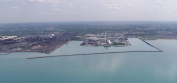
View of the Port of Indiana-Burns Harbor as seen from Lake Michigan

Highways
Education
Burns Harbor is served by Duneland Schools (http://www.duneland.k12.in.us) providing education for grades Kindergarten through 12, and is in close proximity to many higher education facilities including:
- Indiana University Northwest (IUN)
- Ivy Tech Community College of Indiana (Ivy Tech)
- Purdue University North Central (PNC)
- Purdue University Calumet (Purdue Cal)
- Valparaiso University (Valpo)
References
External links
Municipalities and communities of Porter County, Indiana, United States | ||
|---|---|---|
| Cities |  | |
| Towns | ||
| Townships | ||
| CDPs | ||
| Other communities | ||
| Ghost towns | ||
| Footnotes | ‡This populated place also has portions in an adjacent county or counties | |
| Major city |  | |
|---|---|---|
| Cities (over 30,000 in 2020) | ||
| Towns and villages (over 30,000 in 2020) |
| |
| Counties | ||
| Regions | ||
| Sub-regions | ||