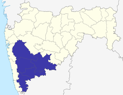
Pune division
Appearance
Pune division | |
|---|---|
 Location of Pune Division in Maharashtra | |
| Coordinates: 18°31′48″N 73°50′24″E / 18.53000°N 73.84000°E | |
| Country | India |
| State | Maharashtra |
| Districts | 1. Kolhapur, 2. Pune, 3. Sangli, 4. Satara, 5. Solapur |
| Area | |
| • Total | 58,268 km2 (22,497 sq mi) |
| • Under irrigation | 8,896 km2 (3,435 sq mi) |
| Population (2001 census) | |
| • Total | 19,973,761 |
| Literacy | 76.95% |
| Main crops | Jowar, wheat, bajra, sugarcane, rice, soybean, onion, groundnut, vegetables, turmeric, grape, pomegranate |
Pune division (also historically known as Desh region) is one of the six administrative divisions of India's Maharashtra state. Pune Division is bound by Konkan Division to the west, Nashik Division to the north, Aurangabad Division to the east, and Karnataka State to the south.[1]
Districts
Kolhapur, Pune, Sangli, Satara, Solapur
History of administrative districts in Pune Division
There have been changes in the names of districts and has seen also the addition of newer districts after India gained Independence in 1947 and also after the state of Maharashtra was formed.
- Notable events include the creation of Sangli District after merging former royal kingdoms of Miraj, Aundh, Sangli, Tasgaon, and Kurundwad.
- The Second event includes the renaming of the erstwhile Poona District as Pune District.
- The Solapur District is under proposal to be divided and a separate Pandharpur District be carved out of existing Solapur district, comprising talukas of Pandharpur, Sangola, Karmala, Mangalwedha, Malshiras and Madha in Solapur District and also talukas of Jath and Atpadi from neighbouring Sangli district, to create a new Pandharpur district.
- The Pune District is under the proposal to be divided and a separate Baramati District be carved out of existing Pune district with the inclusion of the eastern parts of Pune district which include Shirur, Purandar, Daund, Baramati and Indapur talukas as well as Phaltan taluka from neighboring Satara district in the proposed Baramati district.
- The Satara District is under the proposal to be divided and a separate Karad District be carved out of existing Satara district with the inclusion of Karad and Patan as well as talukas of Walwa, Kadegaon and Shirala from neighboring Sangli district in the proposed Karad district.
References
- ^ Rao; Prakash; Patil; Yogesh. Reconsidering the Impact of Climate Change on Global Water Supply, Use, and Management. IGI Global. p. 253. Retrieved 4 November 2016.
