National Register of Historic Places listings in Texas
These historic properties and districts in the state of Texas are listed in the National Register of Historic Places. Properties and/or districts are listed in most of Texas's 254 counties.
The tables linked below are intended to provide a complete list of properties and districts listed in each county. The locations of National Register properties and districts with latitude and longitude data may be seen in an online map by clicking on "Map of all coordinates".[1]
The names on the lists are as they were entered into the National Register; some place names are uncommon or have changed since being added to the National Register.
This National Park Service list is complete through NPS recent listings posted November 15, 2024.[2]
Current listings by county
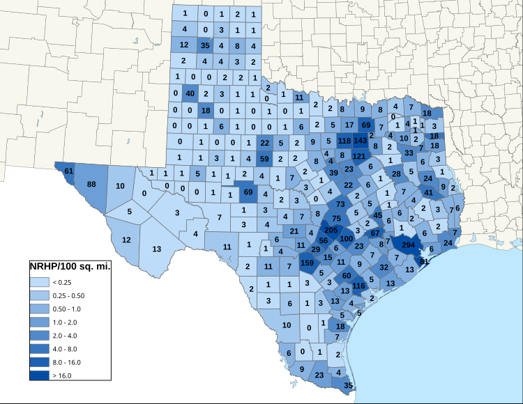
[edit]The map below shows approximate tallies of current listings by county (not always updated to current numbers). The second map shows a partition of the counties into 12 regions of Texas, as defined by the Texas comptroller. The table, further below, reports currently listings by county, updated frequently.[a]
Regions are defined by the Texas State Comptroller, who has partitioned the state into 12 regions for economic performance reporting, as shown here.
As of March 2022, corresponding to the map of tallies of current listings by county, region totals were:
| Region[3] | # of counties |
# of sites | |
|---|---|---|---|
| 1 | Alamo | 19 | |
| 2 | Capital | 10 | |
| 3 | Central | 20 | |
| 4 | Gulf Coast | 13 | |
| 5 | High Plains | 41 | |
| 6 | Metroplex | 19 | |
| 7 | Northwest | 30 | |
| 8 | South Texas | 28 | |
| 9 | Southeast | 15 | |
| 10 | Upper East | 23 | |
| 11 | Upper Rio Grande | 6 | |
| 12 | West Texas | 30 | |
| Total | 254 |
The table, below, reports counts of NRHP and NHL listings for each county, as well as region in which each is located. Click on a "County" column link to see table of listings for a given county, alone. Click on its "Region" column link to see the same table of listings amongst tables for other counties in the region. This latter allows one to see, by "Map all coordinates using OSM" link, the locations of all listings in the region.


See also
[edit]- List of bridges on the National Register of Historic Places in Texas
- List of historical societies in Texas
- List of National Historic Landmarks in Texas
- Recorded Texas Historic Landmark
Notes
[edit]- ^ Based on entries in the National Register Information Database as of April 24, 2008 and new weekly listings posted since then on the National Register of Historic Places web site. Frequent additions to the listings and occasional delistings are made, so the counts here are approximate and not official. New entries are added to the official Register on a weekly basis. Also, the counts in this table exclude boundary increase and decrease listings which modify the area covered by an existing property or district and which carry a separate National Register reference number. The numbers of NRHP listings in each county are documented by tables in each of the individual county list-articles.
- ^ The following sites are listed in multiple counties:
- Austin and Northwestern Railroad Historic District-Fairland to Llano (Burnet and Llano)
- Bartlett Commercial Historic District (Bell and Williamson)
- Butterfield Mail Corridor (Culberson and Hudspeth)
- Cuero I Archeological District (DeWitt and Gonzales)
- Enchanted Rock Archeological District (Gillespie and Llano)
- King Ranch (Kenedy, Kleberg, Nueces and Willacy)
- Lyndon B. Johnson National Historical Park (Blanco and Gillespie)
- Mansfield Cut Underwater Archeological District (Kenedy and Willacy)
- Port Arthur-Orange Bridge (Jefferson and Orange)
- Regency Suspension Bridge (Mills and San Saba)
- Riverside Swinging Bridge (Trinity and Walker)
- State Highway 3-A Bridge at Cibolo Creek (Bexar and Guadalupe)
- State Highway 19 Bridge at Trinity River (Trinity and Walker)
- State Highway 29 Bridge at the Colorado River (Burnet and Llano)
- State Highway 34 Bridge at the Trinity River (Ellis and Kaufman)
- US 190 Bridge at the Colorado River (Lampasas and San Saba)
- US 190 Bridge at the Neches River (Jasper and Tyler)
References
[edit]- ^ The latitude and longitude information provided in this table was derived originally from the National Register Information System, which has been found to be fairly accurate for about 99% of listings. Some locations in this table may have been corrected to current GPS standards.
- ^ National Park Service, United States Department of the Interior, "National Register of Historic Places: Weekly List Actions", retrieved November 15, 2024.
- ^ a b 12 regions as defined by the Texas Comptroller for population and economic performance reporting in 2022, as mapped here.


