
Bangaon Junction railway station
Bangaon Junction বনগাঁ জংশন | ||||||||||||||||
|---|---|---|---|---|---|---|---|---|---|---|---|---|---|---|---|---|
| Kolkata Suburban Railway Junction Station | ||||||||||||||||
 Bangaon Railway Station | ||||||||||||||||
| General information | ||||||||||||||||
| Location | Station Road, Bangaon, West Bengal, 743235 India | |||||||||||||||
| Coordinates | 23°01′50″N 88°49′58″E / 23.0305°N 88.8329°E | |||||||||||||||
| Elevation | 11 metres (36 ft) | |||||||||||||||
| Owned by | Indian Railways | |||||||||||||||
| Operated by | Eastern Railway | |||||||||||||||
| Line(s) | Sealdah-Bangaon line Ranaghat - Bangaon section | |||||||||||||||
| Platforms | 3 | |||||||||||||||
| Tracks | 6 | |||||||||||||||
| Bus stands |
| |||||||||||||||
| Connections |
| |||||||||||||||
| Construction | ||||||||||||||||
| Structure type | Standard (on ground station) | |||||||||||||||
| Parking | No | |||||||||||||||
| Bicycle facilities | No | |||||||||||||||
| Other information | ||||||||||||||||
| Status | Functioning | |||||||||||||||
| Station code | BNJ | |||||||||||||||
| Zone(s) | Eastern | |||||||||||||||
| Division(s) | Sealdah | |||||||||||||||
| History | ||||||||||||||||
| Opened | 1882–84 | |||||||||||||||
| Electrified | 1963–64 with 25 kV overhead line | |||||||||||||||
| Services | ||||||||||||||||
| ||||||||||||||||
Bangaon is a Kolkata Suburban Railway Junction Station on the Sealdah-Bangaon line and Ranaghat-Bangaon line. It is located in North 24 Parganas district in the Indian state of West Bengal. It serves Bangaon and the surrounding areas.
Sealdah–Bangaon line including Barasat–Hasnabad and Ranaghat–Bangaon branch lines | ||||||||||||||||||||||||||||||||||||||||||||||||||||||||||||||||||||||||||||||||||||||||||||||||||||||||||||||||||||||||||||||||||||||||||||||||||||||||||||||||||||||||||||||||||||||||||||||||||||||||||||||||||||||||||||||||||||||||||||||||||||||||||||||||||||||||||||||||||||||||||||||||||||||||||||||||||||||||||||||||||||||||||||||||||||||||||||||||||||||||||||||||||||||||||||||||||||||||||||||||||||||||||||||||||||||||||||||||||||||||||||||||||||||||||||||||||||||||||||||||||||||||||||||||||||||||||||||||||||||||||||||||||||||||||||||||||||||||||||||||||||||||||||||||||||||||||||||||||||||||||||||||||||||||||||||||||||||||||||||||||||||||||||||||||||||||||||||||||||||||||
|---|---|---|---|---|---|---|---|---|---|---|---|---|---|---|---|---|---|---|---|---|---|---|---|---|---|---|---|---|---|---|---|---|---|---|---|---|---|---|---|---|---|---|---|---|---|---|---|---|---|---|---|---|---|---|---|---|---|---|---|---|---|---|---|---|---|---|---|---|---|---|---|---|---|---|---|---|---|---|---|---|---|---|---|---|---|---|---|---|---|---|---|---|---|---|---|---|---|---|---|---|---|---|---|---|---|---|---|---|---|---|---|---|---|---|---|---|---|---|---|---|---|---|---|---|---|---|---|---|---|---|---|---|---|---|---|---|---|---|---|---|---|---|---|---|---|---|---|---|---|---|---|---|---|---|---|---|---|---|---|---|---|---|---|---|---|---|---|---|---|---|---|---|---|---|---|---|---|---|---|---|---|---|---|---|---|---|---|---|---|---|---|---|---|---|---|---|---|---|---|---|---|---|---|---|---|---|---|---|---|---|---|---|---|---|---|---|---|---|---|---|---|---|---|---|---|---|---|---|---|---|---|---|---|---|---|---|---|---|---|---|---|---|---|---|---|---|---|---|---|---|---|---|---|---|---|---|---|---|---|---|---|---|---|---|---|---|---|---|---|---|---|---|---|---|---|---|---|---|---|---|---|---|---|---|---|---|---|---|---|---|---|---|---|---|---|---|---|---|---|---|---|---|---|---|---|---|---|---|---|---|---|---|---|---|---|---|---|---|---|---|---|---|---|---|---|---|---|---|---|---|---|---|---|---|---|---|---|---|---|---|---|---|---|---|---|---|---|---|---|---|---|---|---|---|---|---|---|---|---|---|---|---|---|---|---|---|---|---|---|---|---|---|---|---|---|---|---|---|---|---|---|---|---|---|---|---|---|---|---|---|---|---|---|---|---|---|---|---|---|---|---|---|---|---|---|---|---|---|---|---|---|---|---|---|---|---|---|---|---|---|---|---|---|---|---|---|---|---|---|---|---|---|---|---|---|---|---|---|---|---|---|---|---|---|---|---|---|---|---|---|---|---|---|---|---|---|---|---|---|---|---|---|---|---|---|---|---|---|---|---|---|---|---|---|---|---|---|---|---|---|---|---|---|---|---|---|---|---|---|---|---|---|---|---|---|---|---|---|---|---|---|---|---|---|---|---|---|---|---|---|---|---|---|---|---|---|---|---|---|---|---|---|---|---|---|---|---|---|---|---|---|---|---|---|---|---|---|---|---|---|---|---|---|---|---|---|---|---|---|---|---|---|---|---|---|---|---|---|---|---|---|---|---|---|---|---|---|---|---|---|---|---|---|---|---|---|---|---|---|---|---|---|---|---|---|---|---|---|---|---|---|---|---|---|---|---|---|---|---|---|---|---|---|---|---|---|---|---|---|---|---|---|---|---|---|---|---|---|---|---|---|---|---|---|---|---|---|---|---|---|---|---|---|---|---|---|---|---|---|---|---|---|---|---|---|---|---|---|---|---|---|---|---|---|---|---|---|---|---|---|---|---|---|---|---|---|---|---|---|---|---|---|---|---|---|---|---|---|---|---|---|---|
| ||||||||||||||||||||||||||||||||||||||||||||||||||||||||||||||||||||||||||||||||||||||||||||||||||||||||||||||||||||||||||||||||||||||||||||||||||||||||||||||||||||||||||||||||||||||||||||||||||||||||||||||||||||||||||||||||||||||||||||||||||||||||||||||||||||||||||||||||||||||||||||||||||||||||||||||||||||||||||||||||||||||||||||||||||||||||||||||||||||||||||||||||||||||||||||||||||||||||||||||||||||||||||||||||||||||||||||||||||||||||||||||||||||||||||||||||||||||||||||||||||||||||||||||||||||||||||||||||||||||||||||||||||||||||||||||||||||||||||||||||||||||||||||||||||||||||||||||||||||||||||||||||||||||||||||||||||||||||||||||||||||||||||||||||||||||||||||||||||||||||||
Key
| ||||||||||||||||||||||||||||||||||||||||||||||||||||||||||||||||||||||||||||||||||||||||||||||||||||||||||||||||||||||||||||||||||||||||||||||||||||||||||||||||||||||||||||||||||||||||||||||||||||||||||||||||||||||||||||||||||||||||||||||||||||||||||||||||||||||||||||||||||||||||||||||||||||||||||||||||||||||||||||||||||||||||||||||||||||||||||||||||||||||||||||||||||||||||||||||||||||||||||||||||||||||||||||||||||||||||||||||||||||||||||||||||||||||||||||||||||||||||||||||||||||||||||||||||||||||||||||||||||||||||||||||||||||||||||||||||||||||||||||||||||||||||||||||||||||||||||||||||||||||||||||||||||||||||||||||||||||||||||||||||||||||||||||||||||||||||||||||||||||||||||
| ||||||||||||||||||||||||||||||||||||||||||||||||||||||||||||||||||||||||||||||||||||||||||||||||||||||||||||||||||||||||||||||||||||||||||||||||||||||||||||||||||||||||||||||||||||||||||||||||||||||||||||||||||||||||||||||||||||||||||||||||||||||||||||||||||||||||||||||||||||||||||||||||||||||||||||||||||||||||||||||||||||||||||||||||||||||||||||||||||||||||||||||||||||||||||||||||||||||||||||||||||||||||||||||||||||||||||||||||||||||||||||||||||||||||||||||||||||||||||||||||||||||||||||||||||||||||||||||||||||||||||||||||||||||||||||||||||||||||||||||||||||||||||||||||||||||||||||||||||||||||||||||||||||||||||||||||||||||||||||||||||||||||||||||||||||||||||||||||||||||||||
History
In 1882–84 the Bengal Central Railway Company constructed two lines: one from Dum Dum to Khulna, now in Bangladesh, via Bangaon and the other linking Ranaghat and Bangaon.[1]
The Bengal Central Railway was formed in 1881 to construct and operate a line to Khulna. It was merged with Eastern Bengal Railway in 1903.[2]
Dum Dum-Barasat-Habra-Bangaon sector was electrified in 1963–64.[3]
Routes
In North line commuter trains run up to Ranaghat Jn. (2 trains goes up to Shantipur). In South line commuter trains run mostly up to Sealdah via Barasat Jn. Four trains run on circular route via Dum Dum Jn. and Ballygunge Jn. Three of them go up to Majerhat and one goes to Canning. Bandhan Express, connecting Kolkata to Khulna (Bangladesh) also runs through this station on every thursday.
- Extended trains timetable
| Train | Daily Frequency | Time |
|---|---|---|
| Bongaon Majerhat Local | 3 | 06:35 am 07:30 am 09:50 am |
| Bongaon Canning Local | 1 | 10:47 am |
| Bongaon Shantipur Jn Local | 1 | 11:16 am |
| International link | ||
| Bandhan Express (13129/30) | 1 (weekly) | 08.50 am (KOAA – KLN) 04.27 (KLN – KOAA) [4] [5] |
Border
Bangaon is the last station on the line, but the line goes up to the India-Bangladesh border and beyond.[6][7]
Petrapole, the Indian side of the international border, with a land customs station, handles more than half of the 4 billion dollar trade between India and Bangladesh. With the remote possibility of improvements in the narrow roads leading to the border, because of land acquisition problems, the focus is now on improving the rail transportation system.[8]
Gallery
-
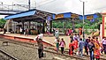
 Local Train at Bangaon station
 -
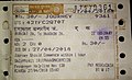 A journey ticket to Bongaon station
 -
 Bongaon Station platforms 2 and 3
 -
 Bongaon station nameplate on platform no 1


References
- ^ "The Chronology of Railway development in Eastern Indian". railindia. Retrieved 2 May 2013.
- ^ "Bengal Central Railway". fibis. Retrieved 2 May 2013.
- ^ "History of Electrification". IRFCA. Retrieved 2 May 2013.
- ^ "Khulna to Kolkata Express timing".
- ^ "Kolkata to Khulna Express timing".
- ^ "Bongaon a green fresh border". Travel template. Retrieved 2 May 2013.
- ^ "Capexil plea to convert Petrapole LCS into port". The Hindu Business Line, 26 March 2004. Retrieved 2 May 2013.
- ^ Pratim Ranjan Bose and Abhisek Law. "Customs wants better rail link through Petrapole". The Hindu Business Line, 3 April 2013. Retrieved 2 May 2013.
External links
Template:Kolkata Suburban Railway stations

