Illinois's 16th congressional district
| Illinois's 16th congressional district | |
|---|---|
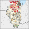
Interactive map of district boundaries since January 3, 2023 | |
| Representative | |
| Area | 9,030.5 sq mi (23,389 km2) |
| Distribution |
|
| Population (2023) | 755,171 |
| Median household income | $80,425[1] |
| Ethnicity |
|
| Cook PVI | R+13[2] |
The 16th congressional district of Illinois is represented by Republican Darin LaHood. Prominent past representatives from the 16th district have included Everett Dirksen, who went on to become the Republican leader in the United States Senate; John B. Anderson, who became the 3rd highest ranking Republican in the House and went on to run as a major independent candidate in the 1980 Presidential election; and Lynn Martin, who later served as United States Secretary of Labor.
For more than six decades, the shape of the 16th district fluctuated far less than that of any other Illinois congressional district. In this time, it generally included the northwest corner of the state, extending just far enough to the east to grab its largest city, Rockford.[3] By the 1990s, it also extended eastward to include part of McHenry County, an outer suburb of Chicago. This geographic stability also contributed to electoral stability. It first became a Rockford-based district for the 1948 election, and from then until 2012 it was represented by just five people, all but one of whom was a Republican. The sole Democrat to have held it in that period, John W. Cox, Jr., only did so for one term.
However, with the new map drawn for 2012, the 16th was significantly redrawn. It was pushed well to the east to include the southwestern exurbs of the Chicago metropolitan area, and stretches from the Wisconsin border to the Indiana border. While it still included most of Rockford's suburbs, half of Rockford itself—essentially the more Democratic western portion of the city—was shifted to the 17th district.
The district was significantly redrawn again after the 2020 census, and is essentially a merger of the more Republican portions of the old 16th and 18th districts.
Composition
[edit]2011 redistricting
[edit]The congressional district covers parts of DeKalb, Ford, Stark, Will and Winnebago counties, and all of Boone, Bureau, Grundy, Iroquois, LaSalle, Lee, Livingston, Ogle and Putnam counties, as of the 2011 redistricting which followed the 2010 census. All or parts of Belvidere, Channahon, DeKalb, Dixon, Loves Park, Machesney Park, Ottawa, Morris, Pontiac, Rockford and Streator are included.[4] The representatives for these districts were elected in the 2012 primary and general elections, and the boundaries became effective on January 5, 2013.
2021 redistricting
[edit]| # | County | Seat | Population |
|---|---|---|---|
| 7 | Boone | Belvidere | 53,202 |
| 11 | Bureau | Princeton | 32,729 |
| 37 | DeKalb | Sycamore | 100,288 |
| 53 | Ford | Paxton | 13,250 |
| 63 | Grundy | Morris | 53,578 |
| 73 | Henry | Cambridge | 48,448 |
| 85 | Jo Daviess | Galena | 21,756 |
| 103 | Lee | Dixon | 33,654 |
| 105 | Livingston | Pontiac | 35,320 |
| 123 | Marshall | Lacon | 11,683 |
| 113 | McLean | Bloomington | 170,441 |
| 141 | Ogle | Oregon | 51,265 |
| 143 | Peoria | Peoria | 177,513 |
| 155 | Putnam | Hennepin | 5,561 |
| 175 | Stark | Toulon | 5,218 |
| 177 | Stephenson | Freeport | 43,105 |
| 179 | Tazewell | Pekin | 129,541 |
| 201 | Winnebago | Rockford | 280,922 |
Cities and CDPs with 10,000 or more people
[edit]- Peoria – 259,781
- Rockford – 148,655
- Bloomington – 78,680
- Normal – 52,736
- Pekin – 31,731
- Belvidere – 25,339
- Loves Park – 23,397
- Machesney Park – 22,950
- East Peoria – 22,484
- Morton – 17,117
- Washington – 16,071
- Dixon – 15,274
- Morris – 14,163
- Channahon – 13,383
- Streator – 12,500
- Pontiac – 11,150
- Roscoe – 10,983
2,500 to 10,000 people
[edit]- Harvard – 9,469
- Rochelle – 9,446
- South Beloit – 7,989
- Rockton – 7,863
- Princeton – 7,832
- Geneseo – 6,539
- Chillicothe – 6,128
- Peoria Heights – 5,908
- Coal City – 5,705
- Eureka – 5,227
- Candlewick Lake – 5,115
- Poplar Grove – 5,049
- Creve Coeur – 4,934
- Marseilles – 4,845
- West Peoria – 4,263
- Dwight – 4,032
- Metamora – 3,904
- Byron – 3,784
- Oregon – 3,604
- Le Roy – 3,512
- Gibson City – 3,475
- Germantown Hills – 3,412
- Galena – 3,308
- Cherry Valley – 2,905
- Mount Morris – 2,861
- Heyworth – 2,791
- Lena – 2,772
- El Paso – 2,756
- Diamond – 2,640
- Marquette Heights – 2,541
- Davis Junction – 2,512
Due to the 2020 redistricting, this district will shift to encompass most of central Northern Illinois, including covering the majority of the Wisconsin-Illinois border. The district takes in Jo Daviess, Ogle, Lee, Stark, Marshall, and Grundy Counties; most of Winnebago, Boone, Bureau, Henry, and McLean Counties; half of Stephenson, Peoria, Tazewell, Putnam, and Livingston Counties; and part of DeKalb and Ford Counties.
Winnebago County is split between this district and the 17th district. They are partitioned by West State Road, West State St, School St, Monroe St, Victory St, North Springfield Ave, Auburn St, North Central Ave, West Riverside Blvd, Eagle Dr, Soo Line Railroad, Park Ridge Rd, East Dr, River Ln, N 2nd St, Windsor Rd, N Alpine Rd, E Riverside Blvd, Forest Hills Rd, Pepper Dr, Cardamon Ln, Sage Dr, Gingeridge Ln, Applewood Ln, Windsor Rd/Broadcast Parkway, McFarland Rd, Harlem Rd, Illinois Highway 39, Keith Creek, Olde Creek Rd, N Trainer Rd, Spring Brook Rd, N Mulford Rd, Spring Creek Rd, Delcy Dr, Taliesen Ln/Jonquil Rd, Arbutus Rd, Saratoga Ln, Norwich Dr, Monticello Ln, Guilford Rd, Mauh-Nah-Tee-See, Inverness Dr, Donna Dr, Garrett Ln, Triton Ave, Apawamis Way E, Shiloh Rd, N Perryville Rd, Argus Dr, Deane Dr, US Highway 20, S Trainer Rd, Laurel Cherry Dr, Stony Creek Way, Newburg Rd, Homewood Dr, Dorchester Dr, Villanova Dr, Highland Ter, Wichita Dr, Capetown Ave, Charles St, S Mulford Rd, Forest Trail Dr, Samuelson Rd, 35th St, Tesa Rd, Sonja Ln, Lockout Dr, Houston Rd, Scarlet Oak Rd, Fruitland Dr, 20th St, Mobile Home Ave, 11th St, Falcon Rd, Beltline Rd, Kishwaukee Rd, Rock River, S Springfield Ave, Prairie Rd, and Tipple Rd. The 15th district takes in the communities of South Beloit, Roscoe, New Milford, Machesney Park, Rockton, Lake Summerset (shared with Stephenson County), Durand, Pecatonica, Westlake Village, Argyle (shared with Boone County), and Cherry Valley; most of Loves Park; and part of Rockford (shared with Ogle County).
Boone County is split between this district and the 11th district. They are partitioned by Orth Rd, Poplar Grove Rd, Woodstock Rd, McKinley Ave, Squaw Prairie Rd, Beloit Rd, Illinois Business Route 20, Kishwaukee River, Wynwood Dr, N Appleton Rd, S Appleton Rd, Illinois Highway 5, and Stone Quarry Rd. The 11th district takes in the communities of Candlewick Lake, Capron, Argyle (shared with Winnebago County), Caledonia, and Timberlane; most of Belvidere; and part of Poplar Grove.
Bureau County is split between this district and the 14th district. They are partitioned by Illinois Highway 26, US Highway 180, 2400 St E, and 2400 Ave N. The 16th district takes in the municipalities of Princeton, Wyanet, Buda, Sheffield, Mineral, Neponset, New Bedford, Manlius, Walnut, Tiskilwa, Ohio, Dover, and La Moille.
Henry County is split between this and the 17th district. They are partitioned on the northwest side by Shaffer Creek, Oakwood Cir, Oakmont Dr, Oakwood Country Club, Glenwood Rd, US Highway 6, E 450th St, Illinois Highway 280, Green River Rd, and Kings Dr. They are partitioned on the southeast side by E 1770th St, N 650th Ave/N 570th Ave, Timber Rd, E 2400th St, and N 1200 St. The 16th district takes in the communities of Cambridge, Geneseo, Orion, Atkinson, Annawan, Lynn Center, Ophiem, Alpha, Cleveland, Osco, Andover, Woodhull, Bishop Hill, Nekoma, and Hooppole.
McLean County is split between this district and the 17th district. They are partitioned by E 1000 North Rd, N 250 East Rd, E 1200 North Rd, Middle Fork Sugar Creek, E 1250 North Rd, N 750 East Rd, E 1300 North Rd, E 1280 North Rd, N 900 East Rd, E 1350 North Rd, E 1400 North Rd, N 1100 East Rd, N Rivian Motorway, King Mill Creek, Illinois Highway 74, Hovey Ave, S Cottage Ave, Gregory St, N Adelaide St, W Raab Rd, N Towanda Ave, E Shelbourne Dr, Old Route 66, Hershey Rd, E College Ave, Illinois Highway 55, Sugar Creek, General Electric Rd, Rainbow Ave, Mill Creek Rd, Clearwater Ave, Newcastle Dr, Illinois Highway 9, S Towanda Barnes Rd, Central Illinois Airport, Winchester Dr, S Hershey Rd, E Oakland Ave, S Veterans Parkway, S Mercer Ave, Norfolk and Southern Railroad, Rhodes Ln, E Hamilton Rd, S Morris Ave, Six Points Rd, W Oakland Ave, Fox Creek Rd, Crooked Creek Rd, Carrington Ln, and N 1200 East Rd. The 16th district takes in the communities of Lexington, Le Roy, Chenoa, El Paso (shared with Woodford County), Hudson, Gridley, Anchor, Saybrook, Bellflower, Colfax, Arrowsmith, Cooksville, Ellsworth, Towanda, Downs, Heyworth, Carlock, Twin Grove, Danvers, and Stanford; northern Normal; and part of Bloomington.
Stephenson County is split between this district and the 17th district. They are partitioned by Daws Rd, Howardsville Rd, Cedarville Rd, N Fawver Rd, and Maize Rd. The 16th district takes in the communities of Davis, Dakota, Orangeville, Winslow, Rock City, and Lake Summerset (shared with Winnebago County); northern Cedarville; and part of Lena.
Peoria County is split between this district and the 17th district. They are partitioned by W Gerber Rd/W Rosenbohm Rd, W Southport Rd, BN & SF Railroad, W Southport Rd, N Townhouse Rd, W Cottonwood Rd, N McAllister Rd, W Greengold Rd, W Farmington Rd, N Kickapoo Creek Rd, Saint Mary's Cemetery, N Swords Ave, N Northcrest Dr, C & NW Railroad, Weaverridge Golf Club, W Charter Oak Rd, Illinois Highway 6, W War Memorial Dr, N Allen Rd, W Northmoor Rd, Big Hollow Creek, West Imperial Dr, West Willow Knolls Dr, North University St, Manning Park, West Teton Dr, Illinois Highway 40, North Prospect Rd, East Prospect Ln, North Montclair Ave, East Euclid Ave, North Grandview Dr, Forest Park Nature Center, Forest Park Apartments, North Galena Rd, Illinois Highway 29, and Forest Park Riverfront-Longshore. The 16th district takes in the communities of Chillicothe, Brimfield, Princeville, Dunlap, Rome, Mossville; northern Peoria; and part of Peoria Heights (shared with Woodford County), West Peoria, Bellevue, and Norwood.
Tazewell County is split between this district and the 17th district. They are partitioned by Illinois River, S 3rd St, Prince St, Elm St, Maple St, Mechanic St, Koch St, 5th St, Illinois Central Railroad, Townline Rd, Highway I-55, Illinois Highway 122, Indian Creek, Southwest Lincoln St, Southeast Main St, Hopedale Rd, Springtown Rd, Mackinaw Rd, and Lagoon Rd. The 16th district takes in the communities of East Peoria, Washington, Morton, Hopedale, Minier, North Pekin, Heritage Lake, Mackinaw, Deer Park (shared with Woodford County), Creve Coeur, Marquette Heights, Goodfield (shared with Woodford County), and Tremont; most of Pekin; and part of South Pekin.
Putnam County is split between this district and the 17th district. They are partitioned by Illinois River, S Front St, E High St, N 2nd St, E Court St, E Mulberry St, N 3rd St, N 4th St, N 6th St, E Sycamore St, S 5th St, Coffee Creek, Illinois Highway 26, and N 600th Ave. The 16th district takes in the communities of McNabb and Magnolia.
Livingston County is split between this district and the 2nd district. They are partitioned by N 1800 Rd East, E 1550 Rd North, N 1600 Rd East, E 1500 Rd North, N 1500 Rd East, W Reynolds St, Highway 55, The Slough, E 1830 Rd North, Old IL-66 South, N 1700 Rd East, N 2125 Rd North, and N 1800 Rd East. The 16th district takes in the communities of Cornell, Flanagan, and Long Point; and part of Pontiac.
DeKalb County is split between this district, the 11th district, and the 14th district. They are partitioned by Myelle Rd, Bass Line Rd, Illinois Highway 23, Whipple Rd, Plank Rd, Swanson Rd, and Darnell Rd. The 16th district takes in the municipality of Kirkland.
Ford County is split between this district and the 2nd district. They are partitioned by E 900N Rd, N Melvin St, E 8th St, and N 500E Rd. The 16th district takes in the municipality of Gibson City.
McHenry County is split between this district and the 9th district, 10th district, and 11th district. The 16th district takes in the communities of Big Foot Prairie, Alden, Harvard, Lawrence, and Chemung.
LaSalle County is split between this district and the 14th district. The 16th district takes in the communities of Ransom Grand Ridge, Kangley, Streator (shared with Livingston County), Leonore, Lostant, Rutland, and Dana; and part of Seneca, Marseilles, and Tonica.
Presidential election results
[edit]- This table indicates how the district has voted in U.S. presidential elections; election results reflect voting in the district as it was configured at the time of the election, not as it is configured today.
| Year | Office | Results |
|---|---|---|
| 2000 | President | George W. Bush 54% – Al Gore 43% |
| 2004 | President | George W. Bush 55% – John Kerry 44% |
| 2008 | President | Barack Obama 50% – John McCain 48% |
| 2012 | President | Mitt Romney 53% – Barack Obama 45% |
| 2016 | President | Donald Trump 55% – Hillary Clinton 38% |
| 2020 | President | Donald Trump 56% – Joe Biden 40% |
Recent election results from statewide races
[edit]- This table indicates how the district has voted in recent statewide elections; election results reflect voting in the district as it is currently configured, not necessarily as it was at the time of these elections.
| Year | Office | Results |
|---|---|---|
| 2016 | President | Donald Trump 58.0% – Hillary Clinton 34.3% |
| Senate | Mark Kirk 59.1% – Tammy Duckworth 34.4% | |
| 2018 | Governor | Bruce Rauner 55.4% – J. B. Pritzker 34.7% |
| Attorney General | Erika Harold 62.7% – Kwame Raoul 34.5% | |
| Secretary of State | Jesse White 51.6% – Jason Helland 45.9% | |
| 2020 | President | Donald Trump 59.6% – Joe Biden 38.1% |
| Senate | Mark Curran 58.3% – Dick Durbin 38.0% | |
| 2022 | Senate | Kathy Salvi 59.2% – Tammy Duckworth 38.9% |
| Governor | Darren Bailey 60.4% – J. B. Pritzker 36.6% | |
| Attorney General | Tom Devore 62.6% – Kwame Raoul 34.8% | |
| Secretary of State | Dan Brady 64.8% – Alexi Giannoulias 32.8% |
Recent election results
[edit]2012
[edit]| Party | Candidate | Votes | % | |
|---|---|---|---|---|
| Republican | Adam Kinzinger (incumbent) | 181,789 | 61.8 | |
| Democratic | Wanda Rohl | 112,301 | 38.2 | |
| Total votes | 294,090 | 100.0 | ||
| Republican hold | ||||
2014
[edit]| Party | Candidate | Votes | % | |
|---|---|---|---|---|
| Republican | Adam Kinzinger (incumbent) | 153,388 | 70.6 | |
| Democratic | Randall Olsen | 63,810 | 29.4 | |
| Total votes | 217,198 | 100.0 | ||
| Republican hold | ||||
2016
[edit]| Party | Candidate | Votes | % | |
|---|---|---|---|---|
| Republican | Adam Kinzinger (incumbent) | 259,722 | 99.9 | |
| Independent | John Burchardt (write-in) | 131 | 0.1 | |
| Total votes | 259,853 | 100.0 | ||
| Republican hold | ||||
2018
[edit]| Party | Candidate | Votes | % | |
|---|---|---|---|---|
| Republican | Adam Kinzinger (incumbent) | 151,254 | 59.1 | |
| Democratic | Sara Dady | 104,569 | 40.9 | |
| Independent | John M. Stassi (write-in) | 2 | 0.0 | |
| Total votes | 255,825 | 100.0 | ||
| Republican hold | ||||
2020
[edit]| Party | Candidate | Votes | % | |
|---|---|---|---|---|
| Republican | Adam Kinzinger (incumbent) | 218,839 | 64.7 | |
| Democratic | Dani Brzozowski | 119,313 | 35.2 | |
| Write-in | 7 | 0.0 | ||
| Total votes | 338,159 | 100.0 | ||
| Republican hold | ||||
2022
[edit]| Party | Candidate | Votes | % | |
|---|---|---|---|---|
| Republican | Darin LaHood (incumbent) | 197,621 | 66.3 | |
| Democratic | Elizabeth Haderlein | 100,325 | 33.6 | |
| Total votes | 297,946 | 100.0 | ||
| Republican hold | ||||
List of members representing the district
[edit]See also
[edit]References
[edit]- ^ "My Congressional District". US Census Bureau.
- ^ "2022 Cook PVI: District Map and List". Cook Political Report. July 12, 2022. Retrieved January 10, 2023.
- ^ Sweeny, Chuck. "Manzullo gears up for primary with new map". Illinois Conservatives (Source: Rockford Register Star). Archived from the original on February 22, 2014. Retrieved September 17, 2014.
- ^ Illinois Congressional District 16 Archived August 17, 2012, at the Wayback Machine, Illinois Board of Elections
- ^ "2012 General Election Official Vote Totals" (PDF). Illinois State Board of Elections. Archived from the original (PDF) on November 19, 2013. Retrieved March 26, 2012.
- ^ "Illinois General Election 2014". Archived from the original on March 6, 2018.
- ^ "Illinois General Election 2016". Archived from the original on March 27, 2019.
- ^ "Official Canvas; General Election; November 6, 2018". Scribd.
- ^ "Election Results 2020 GENERAL ELECTION". Illinois State Board of Elections. December 4, 2020. Retrieved December 4, 2020.
- ^ "Illinois 2020 Election Results". Chicago Sun-Times. November 20, 2020. Retrieved November 20, 2020.
- Martis, Kenneth C. (1989). The Historical Atlas of Political Parties in the United States Congress. New York: Macmillan Publishing Company.
- Martis, Kenneth C. (1982). The Historical Atlas of United States Congressional Districts. New York: Macmillan Publishing Company.
- Congressional Biographical Directory of the United States 1774–present
External links
[edit]- Congressional districts of Illinois
- Boone County, Illinois
- Carroll County, Illinois
- DeKalb County, Illinois
- Jo Daviess County, Illinois
- McHenry County, Illinois
- Ogle County, Illinois
- Stephenson County, Illinois
- Whiteside County, Illinois
- Winnebago County, Illinois
- Constituencies established in 1873
- 1873 establishments in Illinois

