
Wood Buffalo National Park
| Wood Buffalo National Park | |
|---|---|
 Wood Bison | |
| Lua error in Module:Location_map at line 526: Unable to find the specified location map definition: "Module:Location map/data/Canadian National Parks Location.png" does not exist. | |
| Location | Alberta & Northwest Territories, Canada |
| Nearest city | Fort Chipewyan |
| Area | 44,807 km2 (17,300 sq mi) |
| Established | 1922 |
| Governing body | Parks Canada |
| Type | Natural |
| Criteria | vii, ix, x |
| Designated | 1983 (7th session) |
| Reference no. | 256 |
| Country | Canada |
| Region | Europe and North America |
Wood Buffalo National Park, located in northeastern Alberta and southern Northwest Territories, is the largest national park in Canada at 44,807 km2 (17,300 sq mi). It is the second-largest national park in the world,[1] and thirteenth-largest protected area in the world. The park was established in 1922 to protect the world's largest herd of free roaming Wood Bison, currently estimated at more than 5,000. It is one of two known nesting sites of whooping cranes.
The park ranges in elevation from 183 m (600 ft) at the Little Buffalo River to 945 m (3,100 ft) in the Caribou Mountains. The park headquarters is located in Fort Smith, with a smaller satellite office in Fort Chipewyan, Alberta. The park contains one of the world's largest fresh water deltas, the Peace-Athabasca Delta, formed by the Peace, Athabasca and Birch Rivers. It is also known for its karst sinkholes in the north-eastern section of the park. Alberta's largest springs (by volume, with an estimated discharge rate of eight cubic meters per second), Neon Lake Springs, are located in the Jackfish River drainage.[2] Wood Buffalo is located directly north of the Athabasca Oil Sands.
This area was designated a UNESCO World Heritage Site in 1983 for the biological diversity of the Peace-Athabasca Delta, one of the world's largest freshwater deltas, as well as the population of wild bison.[3]
On June 28, 2013, the Royal Astronomical Society of Canada designated Wood Buffalo National Park as Canada's newest and the world's largest Dark-sky preserve. Parks Canada, claims that the designation will help preserve nighttime ecology for the park’s large populations of bats, night hawks and owls, as well as providing opportunities for visitors to experience the Northern lights.[4] The Wood Buffalo National Park had planned to celebrate the new designation with a Dark Sky Festival on August 23–25, 2013, featuring camping, astronomical presentations, a planetarium experience, and night sky viewing opportunities.
History
Before the park
This region has been inhabited by human cultures since the end of the last ice age. Aboriginal peoples in this region have followed variations on the subarctic lifeway, based around hunting, fishing, and gathering. Situated at the junction of three major rivers used as canoe routes for trade — the Athabasca, Peace and the Slave Rivers — the region that later became the national park was well travelled for millennia.
In recorded times, the Dane-zaa (historically called the "Beaver tribe"), the Chipewyan people, the South Slavey (Dene Tha'), and Woods Cree people are known to have inhabited, and sometimes quarrelled over, the region. The Dane-zaa, Chipewyan, and South Slavey speak (or spoke) languages from the Northern Athabaskan family which is also common in the regions to the north and west of the park, and call themselves the "Dene" collectively. The Cree, by contrast, are an Algonquian people and are thought to have migrated here from the east within the timeframe of recorded history.
The Some time after 1781 when a smallpox epidemic decimated the region, the two groups made a peace treaty at Peace Point through a peace pipe ceremony. This is the origin of the name of the Peace River which flows through the region: the river became the boundary with the Dane-zaa to the North and the Cree to the South.
Explorer Peter Pond is believed to have passed through the region in 1785, likely the first European to do so, followed by Alexander Mackenzie three years later. In 1788 fur trading posts were established at Fort Chipewyan just east of the current boundaries of the park and Fort Vermilion just to the west. And the Peace River, which had long been used by the First Nations as a trade route, also now also added to the growing network of canoe routes used in the North American fur trade. From the fur trade, the Métis people emerged as another major group in the region.
Canada purchased the Hudson's Bay Company's claim to the region in 1896, and Agriculture, and the mass in-migration of non-Aboriginal peoples that went with it, was never developed in this part of Western Canada, unlike to the south. The hunting and trapping remained the dominant industry in this region well into the twentieth century, and are still vital to many people here. Following the Klondike Gold Rush of 1897, however, the Canadian governments was keen to extinguish Aboriginal title to the land, so that any mineral wealth found in the future could be exploited despite any objections from First Nations. This led to the signing of Treaty 8 on 21 June 1899. The land then passed into the hand of the federal government as "Crown land".
As a national park
Established in 1922, the park was created on Crown land acquired the territory of Treaty 8 between Canada the local First Nations. The park itself completely surrounds several Indian reserves such as Peace Point and ?Ejere K'elni Kue (also called Hay Camp).
Between 1925 and 1928, over 6,000 plains bison were introduced to the park, where they hybridized with the local wood bison, as well as introducing bovine tuberculosis and brucellosis diseases into the herd. Parks officials have since that time attempted to undo this damage with successive culls of diseased animals. Between 1951 and 1967, four thousand bison were killed and 2,000,000 pounds (910,000 kg) of meat were sold from a special abattoir built at Hay Camp. These smaller culls did not eradicate the diseases, however, and in 1990 a plan was announced to cull the entire herd and restock it with undiseased animals from Elk Island National Park. This plan was abandoned due to a negative public reaction to the announcement.[5] Since that time, wolves, the bison's main predator, have recovered in numbers due to a reduction in control efforts (mostly poisoning), reducing the size of the herd.[citation needed]
In 1983 a 21 year lease was granted to Canadian Forest Products Ltd. to log a 50,000 hectare area of Wood Buffalo National Park. A law suit was filed by the Canadian Parks and Wilderness Society against Parks Canada for violating the National Parks Act. Before the trial commenced, Parks Canada acquiesced and recognized that the lease was invalid and unauthorized by the provisions of the Act.[6]
Wildlife
Wood Buffalo National Park contains a large variety of wildlife species, such as moose, wood bison, American black bear, gray wolf, Canadian lynx, beaver, brown bear, snowshoe hare, Sandhill Crane, Ruffed Grouse, and the world's northernmost population of Red-sided Garter Snakes, which form communal dens within the park.
Wood Buffalo Park contains the only natural nesting habitat for the endangered Whooping Crane. Known as Whooping Crane Summer Range, it is classified as a Ramsar site. It was identified through the International Biological Program. The range is a complex of contiguous water bodies, primarily lakes and various wetlands, such as marshes and bogs, but also includes streams and ponds.
In 2007 the world's largest beaver dam—about 850 metres (2,790 ft)* in length—was discovered in the park using satellite imagery;[7][8] The dam, located at 58°16.3′N 112°15.1′W / 58.2717°N 112.2517°W,[9] about 200 kilometres (120 mi) from Fort Chipewyan, had only been sighted by satellite and fixed-wing aircraft until July 2014.[10]
Transportation
Year-round access is available to Fort Smith by road on the Mackenzie Highway, which connects to Highway 5 near Hay River, Northwest Territories. Commercial flights are available to Fort Smith and Fort Chipewyan from Edmonton.[11] Winter access is also available using winter and ice roads from Fort McMurray through Fort Chipewyan.
Gallery
-
 Location and extent
 -
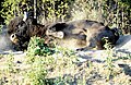 Wood Buffalo (Bison bison athabascae)
 -
 Marmot
 -
 Grosbeak Lake
 -
 American White Pelicans at Rapids of the Drowned (Slave River)
 -
 Beaver Lodge
 -
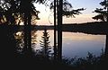 Pine Lake


See also
- National Parks of Canada
- List of National Parks of Canada
- List of Northwest Territories parks
- Mount Buffalo National Park, Australia
Alberta
- List of parks in Alberta
- List of trails in Alberta
- List of mountains in Alberta
- List of waterfalls of Alberta
References
- ^ Johnston, Karl. "Heaven Below Me – Exploring Wood Buffalo National Park from the Air". www.letsbewild.com. Retrieved 16 November 2012.
- ^ Rollins, John. Caves Of The Canadian Rockies And Columbia Mountains.
- ^ "Wood Buffalo National Park: Statement of Significance". UNESCO World Heritage Centre. Retrieved 18 December 2014.
- ^ Thompson, Deborah. "RASC Designates Wood Buffalo National Park as a New Dark Sky Preservepreserve". Retrieved 2013-08-03.
- ^ http://www.environmentandsociety.org/arcadia/northern-bison-sanctuary-or-big-ranch-wood-buffalo-national-park
- ^ Lloyd, David R. (2004). Unnatural law rethinking Canadian environmental law and policy ([Online-Ausg.] ed.). Vancouver: Univ. of British Columbia. ISBN 0-7748-1048-3.
- ^ Kleiss, Karen (May 6, 2010). "Giant beaver pond visible from space". Canwest News Service. The Vancouver Sun. Archived from the original on 2010-05-08. Retrieved 2014-09-18.
- ^ Comte, Michel; Lemieux, Jacques (May 5, 2010). "World's biggest beaver dam discovered in northern Canada". Agence France-Presse. Yahoo!. Archived from the original on 2010-05-09. Retrieved 2014-09-18.
- ^ "EXPLORING BEAVER HABITAT AND DISTRIBUTION WITH GOOGLE EARTH". EcoInformatics International. Retrieved 2014-09-18.
- ^ Klinkenberg, Marty (September 18, 2014). "U.S. explorer reaches world's largest beaver dam: Adventurer bushwacks through dense northeast Alberta boreal forest". Edmonton Journal. Retrieved 2014-09-18.
- ^ Parks Canada - Wood Buffalo National Park of Canada - How to Get There
External links
- Parks Canada web site
- Park at UNESCO World Heritage Site
- Great Canadian Parks
- Wood Buffalo National Park, Canada (IUCN)
Subdivisions of Alberta | |||||||
|---|---|---|---|---|---|---|---|
| Subdivisions | |||||||
| Communities | |||||||
| Cities and urban service areas | |||||||
| Rural municipalities |
| ||||||
| Specialized municipalities | |||||||
| National Parks |
|
|---|---|
| Marine Conservation Areas | |
| National Landmarks | |
| |