
Lorain, Ohio
Lorain, Ohio | |
|---|---|
| City of Lorain | |
    From top left: Lorain central business district; Lorain Palace Theater; the Lorain lighthouse; Charles Berry Bridge in the Lorain Harbor. | |
.png) Seal | |
| Nickname(s): International City, Steel City[1] | |
 Location within the state of Ohio | |
 Location of Lorain in Lorain County | |
| Coordinates: 41°26′54″N 82°10′8″W / 41.44833°N 82.16889°W | |
| Country | United States of America |
| State | Ohio |
| County | Lorain |
| Founded | 1807[2] |
| Incorporated | February, 1817 |
| Incorporated | July 16, 1834 (township)[3] |
| Government | |
| • Type | Mayor–council |
| • Mayor | Chase M. Ritenauer (D) |
| • City Council | Members[4] |
| Area | |
| • Total | 24.14 sq mi (62.52 km2) |
| • Land | 23.67 sq mi (61.31 km2) |
| • Water | 0.47 sq mi (1.22 km2) |
| Elevation | 610 ft (186 m) |
| Population | |
| • Total | 64,097 |
| • Estimate (2015[7]) | 63,647 |
| • Density | 2,707.9/sq mi (1,045.5/km2) |
| Time zone | UTC-5 (EST) |
| • Summer (DST) | UTC-4 (EDT) |
| Zip code(s) | 44052-44053-44054-44055 |
| Area code | 440 |
| FIPS code | 39-44856 |
| GNIS feature ID | 1077529[8] |
| Website | http://www.cityoflorain.org |
Lorain /ləˈreɪn/ is a city in Lorain County, Ohio, United States. The municipality is located in northeastern Ohio on Lake Erie, at the mouth of the Black River, approximately 30 miles west of Cleveland. As of the 2010 census, the city had a total population of 64,097,[9] making it Ohio's tenth largest city, the second largest in Greater Cleveland, and the largest in Lorain County by population.
The city is notable for its deindustrialized economy, formerly being home to the American Ship Building Company Lorain Yard, Ford Motor Company Lorain Assembly Plant, and United States Steel Corporation's sprawling steel mill on the city's south side. The city faces many similar issues to other Rust Belt cities, including population decline and urban decay. Poverty in the city is above the national average at 27%,[10] lower than Cleveland's 36.2%[11] but higher than neighboring Elyria's 22.2%[12]
History
- Conrad Reid was the first mayor after the city became named 'Lorain'.
- By the mid-20th-century, the city had expanded to encompass almost all of the original "Township of Black River", and also portions of Sheffield Twp.
Ford Motor Company had the Lorain Assembly Plant in the city, mostly known for assembling the Ford Econoline (E-series) van, Ford Torino and Mercury Montego, and beginning in 1975 the Ford Thunderbird and Mercury Cougar (through 1997); the plant ceased all production on December 14, 2005 because the UAW and Ford management were unable to come to terms on a new contract. The sprawling United States Steel Mill stretches for nearly 3 miles (4.8 km) on the city's south side. These mills had operated in the city since 1895 and employed thousands of local residents. Though the blast furnaces were idled in late 2008, Republic Steel announced in December 2011 that they would be building electric arc furnaces to once again make steel in Lorain. However, Republic Steel closed its doors for good in July 2016.
Geography
Lorain, part of the Cleveland–Elyria–Mentor metropolitan area, is located at 41°26′54″N 82°10′8″W / 41.44833°N 82.16889°W (41.448241, -82.168862).[13]
According to the United States Census Bureau, the city has a total area of 24.14 square miles (62.52 km2), of which 23.67 square miles (61.31 km2) is land and 0.47 square miles (1.22 km2) is water.[5]
The Charles Berry Bridge is located in Lorain, and is the second-largest bascule bridge in the world.
Demographics
| Census | Pop. | Note | %± |
|---|---|---|---|
| 1880 | 1,595 | — | |
| 1890 | 4,863 | 204.9% | |
| 1900 | 16,028 | 229.6% | |
| 1910 | 28,883 | 80.2% | |
| 1920 | 37,205 | 28.8% | |
| 1930 | 44,512 | 19.6% | |
| 1940 | 44,125 | −0.9% | |
| 1950 | 51,202 | 16.0% | |
| 1960 | 68,932 | 34.6% | |
| 1970 | 78,185 | 13.4% | |
| 1980 | 75,416 | −3.5% | |
| 1990 | 71,245 | −5.5% | |
| 2000 | 68,652 | −3.6% | |
| 2010 | 64,097 | −6.6% | |
| 2016 (est.) | 63,730 | [14] | −0.6% |
| U.S. Decennial Census[15] 2012 Estimate[16] | |||
2000 census
As of the census of 2000, there were 68,652 people, 26,434 households, and 17,975 families residing in the city. The population density was 2,858.1 people per square mile (1,103.5/km²). There were 28,231 housing units at an average density of 1,175.5/sq mi (453.8/km²). The racial makeup of the city was 69.70% White, 15.94% African American, 0.44% Native American, 0.33% Asian, 0.03% Pacific Islander, 9.56% from other races, and 3.99% from two or more races. Hispanic or Latino of any race were 21.03% of the population.
There were 26,434 households out of which 33.3% had children under the age of 18 living with them, 43.6% were married couples living together, 19.2% had a female householder with no husband present, and 32.0% were non-families. 27.4% of all households were made up of individuals and 10.7% had someone living alone who was 65 years of age or older. The average household size was 2.57 and the average family size was 3.11.
In the city the population was spread out with 28.3% under the age of 18, 9.0% from 18 to 24, 28.2% from 25 to 44, 20.5% from 45 to 64, and 14.0% who were 65 years of age or older. The median age was 34 years. For every 100 females there were 90.2 males. For every 100 females age 18 and over, there were 85.4 males.
The median income for a household in the city was $33,917, and the median income for a family was $39,454. Males had a median income of $34,120 versus $23,065 for females. The per capita income for the city was $16,340. About 14.2% of families and 17.1% of the population were below the poverty line, including 26.5% of those under age 18 and 9.2% of those age 65 or over.
2010 census
As of the census[6] of 2010, there were 64,097 people, 25,529 households, and 16,368 families residing in the city. The population density was 2,707.9 inhabitants per square mile (1,045.5/km2). There were 29,144 housing units at an average density of 1,231.3 per square mile (475.4/km2). The racial makeup of the city was 67.9% White, 17.6% African American, 0.5% Native American, 0.4% Asian, 8.3% from other races, and 5.4% from two or more races. Hispanic or Latino of any race were 25.2% of the population.
There were 25,529 households of which 33.7% had children under the age of 18 living with them, 37.1% were married couples living together, 21.0% had a female householder with no husband present, 6.1% had a male householder with no wife present, and 35.9% were non-families. 30.8% of all households were made up of individuals and 11.5% had someone living alone who was 65 years of age or older. The average household size was 2.48 and the average family size was 3.09.
The median age in the city was 36.8 years. 26.7% of residents were under the age of 18; 8.8% were between the ages of 18 and 24; 24.6% were from 25 to 44; 26% were from 45 to 64; and 13.9% were 65 years of age or older. The gender makeup of the city was 47.5% male and 52.5% female.
Economy
CenturyTel of Ohio is based in Lorain.
Top employers
According to the City's 2013 Comprehensive Annual Financial Report, [17] the top employers in the city are:
| # | Employer | # of employees |
|---|---|---|
| 1 | Mercy Health | 1,657 |
| 2 | Lorain City School District | 870 |
| 3 | Lorain Tubular | 796 |
| 4 | Republic Steel | 633 |
| 5 | CAMACO, Inc. | 500 |
| 6 | The City Of Lorain | 468 |
| 7 | Grace Management Services | 314 |
| 8 | Cleveland Clinic | 300 |
| 9 | The Nord Center | 228 |
| 10 | Walmart | 211 |
Parks and Recreation
There are 51 parks managed by the city parks and recreation department.
Lakeview Park
Lakeview Park is bisected by West Erie Avenue (U.S. Route 6), with the northern section being managed by the Lorain County Metro Parks and the southern by the city. The park was established circa 1917 under Mayor Leonard M. Moore as a way of providing more publicly accessible space on the lakefront. There were 8 casualties as a result of the tornado in 1924, which also destroyed all of the original bathhouse except for the concrete arches, which provide the support as the base for the current bathhouse. The bathhouse was rebuilt after the tornado and replaced once more in 2007, following the takeover of the park in 2006 by the Lorain County Metro Parks.
The Lorain County Metro Parks section of Lakeview Park features a playground on the beach, volleyball courts, a bathhouse with eight family changing rooms, five showers, and a concession stand, several gazebos and picnic shelters, lawn bowling, a color-changing fountain, an Easter egg basket, and a historical rose garden. The Lakeview Fountain was built in 1935 with local Amherst sandstone and has a multi-color display at night, with the spray of the fountain reaching 30 to 50 feet in height. The Easter basket was dedicated on April 3, 1941 as the "floral basket," featuring the design patented by Lorain Parks Department employee David Shukait; traditionally, families in Lorain, in celebration of Easter, take an annual photo at the basket.[18] The rose garden was originally dedicated on May 30, 1932 and has 2,500 roses in 48 beds. The shape of the garden, a wheel with eight spokes, is the Rotary International emblem in honor of the 17 community organizations that funded the garden initially, including the Lorain Rotary. The garden was restored in 2005 and roses are planted to honor and commemorate those that had ties to the community or garden itself in city history. [19]
The city operated section of Lakeview Park features baseball/softball fields, basketball courts, and tennis courts.
Law and Government
Politics in the city have traditionally been closely tied to the local Democratic Party. However, through the years Republicans occasionally have been able to win offices. Since the late 1990s, Lorain has elected all Democrats to city council, but in 1999 a Republican, Craig L. Foltin, was elected mayor then re-elected in 2003.[20]
Voter turnout for the 2016 General Election in Lorain was 24,198 out of a registered 40,885 voters, or a 59.19% turnout rate. Democrat Hillary Clinton captured 15,192 votes, or 62.78%; Republican Donald Trump captured 7,584 votes, or 31.34%; Independent Gary Johnson captured 613 votes, or 2.53%; Green Jill Stein captured 222 votes, or 0.92%. Other candidates had marginal amounts of write-in votes; additionally, it is possible that some voters did not select a presidential candidate when casting their ballot.[21][22]
Federally, most of Lorain is part of Ohio's 9th congressional district, represented by Democrat Marcy Kaptur. A tiny section in the south is in Ohio's 4th congressional district, represented by Republican Jim Jordan.
Mayor and Council
Lorain operates on a ward-based system. City government is of the Mayor-Council form and operates as a statutory city under the laws and regulations set by the Ohio Constitution, making it one of the largest Ohio cities to operate without a charter. The mayor functions as the chief of the executive branch and job includes determining city laws, spurring economic development, planning and administering city projects, delivering city services, negotiating city contracts, and budgeting.[23]
The council has eight members elected by ward and three members elected at-large, with one council member presiding as President of Council. The Lorain city council determines the salary of city officials and employees and enacts ordinances and resolutions of city services, tax levies, appropriating and borrowing money, licensing, regulating business, commerce, and other municipal purposes. Council members serve two-year terms.[24]
Law
City Law Director
Lorain has a City Law Director, Patrick D. Riley, whose responsibilities include serving as legal counsel for all elected officials, directors, and council members of the city; preparing all contracts, bonds (including appropriation and borrowing of funds), ordinances (including reviewing ordinances to be considered by Lorain City Council), and other written instruments of the city; prosecuting and defending the city from all complaints, suits, and controversies; and, serving as the prosecuting attorney for the Lorain Municipal Court in prosecution of cases for the city and Sheffield Township. The City Law Director serves a four-year term.[25]
Municipal Court
The Lorain Municipal Court jurisdiction covers the cities of Lorain and Sheffield Lake, and Sheffield Township. The court oversees legal judgments on any violations of city ordinances or any misdemeanors committed within jurisdiction. Additionally, the court has power to hold preliminary hearings in felony cases (committed within the jurisdiction) and to discharge, recognize, or commit (carry-out or perpetrate) the accused. The court also has jurisdiction in lawsuits where the amount to be recovered is lower than $15,000; lawsuits for recovery of property, contracts, interpleader, replevin, forcible entry and detainer; to provide judgment in sale of personal proverty and for the foreclosure and marshalling of liens. The Lorain Municipal Court has the power to rule on any lawsuits for injunction to prevent or terminate violations of Lorain's ordinances and regulations that may be enacted or promulgated under the city police power. The court has jurisdiction in all actions and proceedings for the sale of real property under a lien decided by the municipal court, actions for the recovery of real property situated within the court's jurisdiction (eminent domain), and all actions for the foreclosure of a mortgage or real property to secure a money payment. Judgments from one court to another is authorized to be transferred and any proceedings for collection may be judged or ruled the same as it had been in the transferor court.[26]
Police
The Lorain Police Department was established in 1853 and is now has 113 police officers and 34 civilian employees. Responsibilities for the Lorain police are to prevent crime, enforce laws in a fair and impartial manner, and the apprehension of people who violate the law.[27]
Culture
Over 70 different nationalities live in the Lorain area, hence the nickname "The International City." One of the highlights of the summer season is the Lorain International Festival. Many were originally attracted by work in the steel mills and ship yards. Lorain is sometimes referred to as Steel City because of its well-known steel mill. Downtown Lorain was devastated by a tornado in 1924 and as part of an initiative to rebuild the downtown several historic buildings were constructed, including the Lorain Palace Theatre which opened in 1928 and continues to operate today.[28]
Notable people
- Terry Anderson, journalist and former Lebanese hostage
- Dimitra Arliss, actress
- Don Barden, Detroit businessman and owner of several large U.S. based casinos, Served 2 terms as Lorain's first black city councilman.
- Charles J. Berry, Corporal, winner of the Medal of Honor during World War II
- Michael Dirda, Pulitzer Prize–winning book critic
- Stevan Dohanos, artist
- Gerald Freedman, American theatre director, librettist, and lyricist, and a college dean.
- Eddy Gragus, professional cyclist and 1996 US Professional Cycling Champion
- Diane Grob Schmidt, 2015 president of the American Chemical Society
- Robert Galambos (1914–2010), researcher who discovered how bats use echolocation.[29]
- Quincy Gillmore, General
- Ellen Hanley, singer
- William Hanley, author
- Raymont Harris, NFL running back
- Lofton Henderson, Major, a hero of the Battle of Midway
- Anthony Hitchens, Clearview High School Graduate, Dallas Cowboys Linebacker, Iowa Hawkeye
- JoBea Way Holt, planetary scientist
- Ernest J. King, Fleet Admiral, Chief of Naval Operations and Fleet Admiral of the U.S. Atlantic Fleet in World War II
- Mary Lawrence, film and television actress
- Ray Lawrence, bandleader, record company executive, record producer and personal manager.
- Sam McPheeters, singer of Born Against
- Jason Molina, singer-songwriter
- Toni Morrison, Nobel Prize laureate author
- Chad Muska, professional skateboarder, was born there, currently resides in Woodland Hills, California
- Don Novello, aka Father Guido Sarducci, comedian featured on Saturday Night Live
- Ward Van Orman, three-time winner of the Gordon Bennett Race
- Robert F. Overmyer, Colonel in the United States Marine Corps, test pilot and astronaut
- Martha Piper, former chancellor and president of the University of British Columbia
- Helen Steiner Rice, author and poet
- Pam Robinson, co-founder of the American Copy Editors Society, a national journalism organization
- Jaclyn Bradley Palmer, singer, songwriter and filmmaker
- Vince Villanucci, NFL player
- Bruce Weigl, prize-winning poet
- Matt Wilhelm, football player, Elyria Catholic graduate, NFL Linebacker, Ohio State national champion and Super Bowl champ
- General Johnnie E. Wilson
Gallery
-
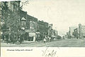 Broadway, looking north, about 1908
 -
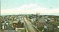 Aerial view, looking north, 1908-1918
 -
 "At the loop", 1913
 -
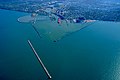 Aerial view of the harbor at Lorain, Ohio. View is to the southeast.
 -
 Broadway, Downtown


See also
References
- ^ Lee, Trymaine. "The Heartland: Life and Loss in Steel City". msnbc.com. MSNBC. Retrieved 19 December 2016.
- ^ "History of Lorain - Chronology". Lorain Public Library System. Lorain Public Library. Retrieved 19 December 2016.
- ^ Remarkable Ohio http://remarkableohio.org/picture.php?/5444/category/912. Retrieved 1 June 2016.
{{cite web}}: Missing or empty|title=(help) - ^ "City Council", City of Lorain.Retrieved December 18, 2016.
- ^ a b "US Gazetteer files 2010". United States Census Bureau. Archived from the original on 2012-07-14. Retrieved 2013-01-06.
{{cite web}}: Unknown parameter|deadurl=ignored (|url-status=suggested) (help) - ^ a b "American FactFinder". United States Census Bureau. Retrieved 2013-01-06.
- ^ "Population Estimates". United States Census Bureau. Retrieved 2016-06-04.
- ^ "US Board on Geographic Names". United States Geological Survey. 2007-10-25. Retrieved 2008-01-31.
- ^ "American FactFinder2". Retrieved 2010-03-20.
- ^ city, Ohio/POVERTY/BLW_LVL_PCT "Lorain city, Ohio Individuals below poverty level". United States Census Bureau American Factfinder. U.S. Department of Commerce. Retrieved 19 December 2016.
{{cite web}}: Check|url=value (help) - ^ city, Ohio/POVERTY/BLW_LVL_PCT "Cleveland city, Ohio Individuals below poverty level". United States Census Bureau American Factfinder. U.S. Department of Commerce. Retrieved 19 December 2016.
{{cite web}}: Check|url=value (help) - ^ Bureau, U.S. Census. city, Ohio/POVERTY/BLW_LVL_PCT "American FactFinder - Community Facts". factfinder.census.gov. Retrieved 19 December 2016.
{{cite web}}: Check|url=value (help) - ^ "US Gazetteer files: 2010, 2000, and 1990". United States Census Bureau. 2011-02-12. Retrieved 2011-04-23.
- ^ "Population and Housing Unit Estimates". Retrieved June 9, 2017.
- ^ United States Census Bureau. "Census of Population and Housing". Retrieved November 20, 2013.
- ^ "Annual Estimates of the Resident Population: April 1, 2010 to July 1, 2012". Archived from the original on October 19, 2013. Retrieved November 20, 2013.
{{cite web}}: Unknown parameter|deadurl=ignored (|url-status=suggested) (help) - ^ "Comprehensive Annual Financial Report: Year Ended December 31, 2013" (PDF). City of Lorain. p. 187.
- ^ Lorain Historical Society Blanket Brochure. Lorain: Lorain Historical Society. September 2016.
{{cite book}}:|access-date=requires|url=(help) - ^ "Lakeview Park at Lorain County Metro Parks". metroparks.cc. Retrieved 2 January 2017.
- ^ "2003 General Election Results" (PDF). Lorain County Board of Elections. Lorain County Board of Elections. November 4, 2003. Retrieved January 15, 2016.
- ^ "2016 General Election, Lorain County, Ohio - Turnout Report" (PDF). November 23, 2016. Retrieved 21 December 2016.
{{cite journal}}: Cite journal requires|journal=(help) - ^ Lorain County, OH General Election November 8, 2016 - Official Results (PDF). Lorain County Board of Elections. Retrieved 21 December 2016.
- ^ "Mission & Purpose". www.cityoflorain.org. Retrieved 21 December 2016.
- ^ "City Council". www.cityoflorain.org. Retrieved 21 December 2016.
- ^ "Law Department". www.cityoflorain.org. Retrieved 21 December 2016.
- ^ "Courts, Lorain Municipal". www.cityoflorain.org. Retrieved 21 December 2016.
- ^ "About Our Department". Lorain Police Department. 30 January 2014. Retrieved 21 December 2016.
- ^ Lorain Palace Civic Center in Lorain, OH - Cinema Treasures
- ^ Martin, Douglas. "Robert Galambos, Neuroscientist Who Showed How Bats Navigate, Dies at 96", The New York Times, July 15, 2010. Accessed July 16, 2010.
External links
- City of Lorain
- Ohio Business College Lorain Campus
- Black River Historical Society - The Museum of the City of Lorain
- Local Announcements, Business Listings and Events Calendar
- U.S. Coast Guard Auxiliary Flotilla 092-06-04 Lorain, Ohio
 Lorain travel guide from Wikivoyage
Municipalities and communities of Lorain County, Ohio, United States | ||
|---|---|---|
| Cities |  | |
| Villages | ||
| Townships | ||
| CDPs | ||
| Unincorporated communities | ||
| Ghost town | ||
| Footnotes | ‡This populated place also has portions in an adjacent county or counties | |