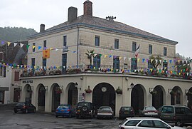
Salies-de-Béarn
You can help expand this article with text translated from the corresponding article in French. (December 2008) Click [show] for important translation instructions.
|
Salies-de-Béarn | |
|---|---|
 Town Hall | |
| Country | France |
| Region | Nouvelle-Aquitaine |
| Department | Pyrénées-Atlantiques |
| Arrondissement | Pau |
| Canton | Salies-de-Béarn |
| Intercommunality | Salies-de-Béarn |
| Government | |
| • Mayor (2001–2008) | Lucien Basse-Cathalinat |
| Area 1 | 52.08 km2 (20.11 sq mi) |
| Population (2006) | 4,993 |
| • Density | 96/km2 (250/sq mi) |
| Time zone | UTC+01:00 (CET) |
| • Summer (DST) | UTC+02:00 (CEST) |
| INSEE/Postal code | 64499 /64270 |
| Elevation | 28–202 m (92–663 ft) (avg. 56 m or 184 ft) |
| 1 French Land Register data, which excludes lakes, ponds, glaciers > 1 km2 (0.386 sq mi or 247 acres) and river estuaries. | |
Salies-de-Béarn (Occitan: Salias) is a commune in the Pyrénées-Atlantiques department in south-western France.
The name comes from its naturally occurring saline water (Gascon salias for Standard Occitan salinas). During the occupation of France by Nazi Germany, Salies was on the border between the occupied zone and the free zone.
Salies-de-Bearn served as the setting of the Trevanian penned novel The Summer of Katya. In that book, it took the name Salies-les-Bains.
See also
References
Wikimedia Commons has media related to Salies-de-Béarn.


