
Barking station: Difference between revisions
DanielRigal (talk | contribs) Undid revision 447698704 by 86.164.114.52 (talk) That battle was lost in 1965. Please give it up |
No edit summary |
||
| Line 69: | Line 69: | ||
| tubeexits10 = {{increase}} 13.720 |
| tubeexits10 = {{increase}} 13.720 |
||
}} |
}} |
||
'''Barking station''' is a railway station served by [[National Rail]] and [[London Underground]] services. It is located in [[Barking]] in the [[London Borough of Barking and Dagenham]] in |
'''Barking station''' is a railway station served by [[National Rail]] and [[London Underground]] services. It is located in [[Barking]] in the [[London Borough of Barking and Dagenham]] in east [[London]], England. The station is in [[Travelcard Zone 4|Zone 4]], has nine platforms, and is managed by [[c2c]]. It has been proposed that ownership of the station could transfer to [[Transport for London]].<ref name=c2c_extend>Passenger Focus - [http://www.passengerfocus.org.uk/news-and-publications/document-search/document.asp?dsid=1790 Passenger Focus’ response to c2c’s proposed franchise extension]</ref> In 2009 the station was identified as one of the ten worst [[United Kingdom railway station categories|category B]] interchange stations for mystery shopper assessment of fabric and environment, and is set to receive a share of £50m funding for improvements.<ref>{{ cite web | title=£50m revamp for 'worst stations' | publisher=BBC News | url=http://news.bbc.co.uk/1/hi/uk/8363621.stm | date=2009-11-17 | accessdate=2009-11-17 }}</ref> The station became an interchange with the [[East London Transit]] in 2010. |
||
==History== |
==History== |
||
Revision as of 07:59, 27 October 2011
| Barking | |
|---|---|
 Station forecourt | |
| Location | Barking |
| Local authority | London Borough of Barking and Dagenham |
| Managed by | c2c |
| Owner | Network Rail |
| Station code(s) | BKG |
| Number of platforms | 9 (facing 8 tracks) |
| Accessible | Yes[1][2] |
| Fare zone | 4 |
| London Underground annual entry and exit | |
| 2008 | |
| 2009 | |
| 2018 | |
| 2019 | |
| 2020 | |
| 2021 | |
| 2022 | |
| National Rail annual entry and exit | |
| 2006–07 | |
| 2007–08 | |
| 2008–09 | |
| 2009–10 | |
| – interchange | 0.211 million[9] |
| Key dates | |
| 1854 | Opened by LT&SR |
| 1902 | District line started |
| 1905 | District withdrawn |
| 1908 | District line restarted |
| Other information | |
| External links | |
Barking station is a railway station served by National Rail and London Underground services. It is located in Barking in the London Borough of Barking and Dagenham in east London, England. The station is in Zone 4, has nine platforms, and is managed by c2c. It has been proposed that ownership of the station could transfer to Transport for London.[10] In 2009 the station was identified as one of the ten worst category B interchange stations for mystery shopper assessment of fabric and environment, and is set to receive a share of £50m funding for improvements.[11] The station became an interchange with the East London Transit in 2010.
History
The station was opened in 1854 by the London Tilbury and Southend Railway (LTSR) on their new line to Tilbury, which split from the Eastern Counties Railway (ECR) at Forest Gate. A shorter route from London between Little Ilford and Gas Factory Junction in Bow, and avoiding the ECR, opened in April 1858. A "Pitsea direct" branch was completed in June 1888 giving more direct access to Southend-on-Sea via Upminster, and avoiding Tilbury. In 1894 the Tottenham and Hampstead Junction Railway was extended by means of the Tottenham and Forest Gate Railway to join the 1854 line from Forest Gate to Tilbury. District line services initially operated over the tracks of the LTSR from 1902. In 1905 a pair of tracks was electrified as far as East Ham and the service was cut back there. It was extended back to Barking in 1908 and eastwards to Upminster, over a new set of tracks, from 1932. Hammersmith and City line, then known as the Metropolitan line, service began in 1936.
The station booking hall was completely rebuilt 1959-61 to designs by architect John Ward of British Railways Eastern Region Architect's Department. Pevsner states it was "erected to coincide with electrification of the railway" and that "it is commensurately modern in outlook and unquestionably one of the best English stations of this date".
The station was reopened by the Queen in 1961.[12] It is now a Grade II listed building.[13]
Services
On the Underground, it is served by the District and Hammersmith & City Lines and forms the eastern terminus for the Hammersmith & City whilst District Line services continue eastward to Template:LUL stations. On National Rail, the station is served by c2c and London Overground services.
As of May 2011[update], the typical off-peak service is:
- 8 tph (trains per hour) to Fenchurch Street (c2c)
- 6 tph to Template:LUL stations via Template:LUL stations (District Line)
- 6 tph to Template:LUL stations via Tower Hill (District Line)
- 4 tph to Gospel Oak (London Overground)
- 3 tph to Template:LUL stations via Template:LUL stations (Hammersmith & City Line)
- 12 tph (trains per hour) to Template:LUL stations (District Line)
- 4 tph to Shoeburyness via Upminster (c2c)
- 2 tph to Southend Central via Upminster and Grays (c2c)
- 2 tph to Grays via Rainham (c2c)
Ticket office
The Ticket Office is managed by c2c and has seven serving windows. TRIBUTE and FasTIS ticket machines are in use. Tickets are available for National Rail, as well as London Underground. Oyster Cards can also be issued at the Ticket Office. There are four Shere Fastticket and four Scheidt and Bachman FAA-2000/TS ticket machines, which can issue tickets ordered on line (Tickets on Demand or 'TOD'). As of 20 March 2009 they do not sell Oyster products, despite the fact that from the 11th November 2007 all the lines serving the station will accept Oyster Pay as you go.
7 Ticket Barriers and a gate control access to all platforms.
Access
The station has four sets of stairs from the platforms to the overbridge and the booking hall. Four corresponding ramps connect to each other via a subway connection. They access: 1 & 1a; 2, 3 & 4; 5 & 6; and 7 & 8. There is lift access from the booking hall to platforms 1 & 1a and step free access to all other platforms from there via the subway and ramps.
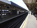
Gallery
-
 Station Building
 -
 Eastbound District line platforms 1a (right) and 2 (left) looking west
 -
 Main line platforms 4 and 5 looking east
 -
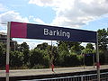 Station signage
 -
 Fenchurch Street - Shoeburyness train approaching Barking in 1948
 -
 Up Tilbury Line train leaving Barking for Fenchurch Street in 1955
 -
 View westward, towards London in 1961


Transport connections
Several London Bus routes connect with the site of the station and it is (since 20 February 2010) served by routes EL1 and EL2 (phase one of the East London Transit).[14]
London Buses routes EL1 (24 hrs), EL2, 5, 62, 169, 238, 287, 368, 387, School bus routes 687 and Night routes N15.
References
- ^ "Step free Tube Guide" (PDF). Transport for London. April 2021. Archived (PDF) from the original on 15 May 2021.
- ^ "London and South East" (PDF). National Rail. September 2006. Archived from the original (PDF) on 6 March 2009.
- ^ a b {"Multi-year station entry-and-exit figures (2007–2017)". London Underground station passenger usage data. Transport for London. January 2018. Archived from the original (XLSX) on 31 July 2018. Retrieved 22 July 2018. Cite error: The named reference "infobox_stats_ref_tube_2007" was defined multiple times with different content (see the help page).
- ^ "Station Usage Data" (CSV). Usage Statistics for London Stations, 2018. Transport for London. 23 September 2020. Archived from the original on 14 January 2023. Retrieved 11 October 2023.
- ^ "Station Usage Data" (XLSX). Usage Statistics for London Stations, 2019. Transport for London. 23 September 2020. Archived from the original on 9 November 2020. Retrieved 9 November 2020.
- ^ "Station Usage Data" (XLSX). Usage Statistics for London Stations, 2020. Transport for London. 16 April 2021. Retrieved 1 January 2022.
- ^ "Station Usage Data" (XLSX). Usage Statistics for London Stations, 2021. Transport for London. 12 July 2022. Retrieved 7 September 2022.
- ^ "Station Usage Data" (XLSX). Usage Statistics for London Stations, 2022. Transport for London. 4 October 2023. Retrieved 10 October 2023.
- ^ a b c d e "Estimates of station usage". Rail statistics. Office of Rail Regulation. Please note: Some methodology may vary year on year.
- ^ Passenger Focus - Passenger Focus’ response to c2c’s proposed franchise extension
- ^ "£50m revamp for 'worst stations'". BBC News. 2009-11-17. Retrieved 2009-11-17.
- ^ Laurence Menear (1983). London's Underground Stations: A Social and Architectural Study. Baton Transport.
- ^ "People, Time and Place London Borough of Barking and Dagenham Heritage Strategy" (PDF). Barking and Dagenham London Borough Council. Retrieved 2009-11-17.
- ^ Transport for London - East London Transit route map (PDF)
External links
- Station information from c2c
- Station information from National Rail
- Station information from Transport for London
| Stations |
| ||||
|---|---|---|---|---|---|
| Rolling stock | |||||
| History |
| ||||
| See also | |||||
| |||||||||||||||||||||
| Companies and organisations |
| ||||||||||||||||||
|---|---|---|---|---|---|---|---|---|---|---|---|---|---|---|---|---|---|---|---|
| Airports |
| ||||||||||||||||||
| Major stations |
| ||||||||||||||||||
| Roads |
| ||||||||||||||||||
| Ticketing | |||||||||||||||||||
| Other | |||||||||||||||||||
| Former BR sectors | |||||||||||||||||||
- Rail transport stations in London fare zone 4
- District Line stations
- Hammersmith & City Line stations
- Railway stations served by London Overground
- Railway stations in Barking and Dagenham
- Tube stations in Barking and Dagenham
- Former London, Tilbury and Southend Railway stations
- Railway stations opened in 1854
- Railway stations served by c2c
- Grade II listed buildings in London
- DfT Category B stations