
Green Bay, Wisconsin
Green Bay | |
|---|---|
 | |
|
Seal | |
| Country | United States |
| State | Wisconsin |
| County | Brown |
| Government | |
| • Mayor | Jim Schmitt |
| Area | |
| • City | 55.96 sq mi (144.94 km2) |
| • Land | 45.47 sq mi (117.77 km2) |
| • Water | 10.49 sq mi (27.17 km2) |
| Elevation | 581 ft (177 m) |
| Population | |
| • City | 104,057 |
| • Estimate (2012[3]) | 104,868 |
| • Density | 2,288.5/sq mi (883.6/km2) |
| • Metro | 306,241 |
| Time zone | UTC−6 (Central) |
| • Summer (DST) | UTC−5 (CDT) |
| Area code | 920 |
| FIPS code | 55-31000Template:GR |
| GNIS feature ID | 1565801Template:GR |
| Website | www.greenbaywi.gov |
Green Bay is a city in and the county seat of Brown County in the U.S. state of Wisconsin,Template:GR located at the head of Green Bay, a sub-basin of Lake Michigan, at the mouth of the Fox River. It has an elevation of 581 feet (177 m) above sea level and is located 112 miles (180 km) north of Milwaukee. The population was 104,057 at the 2010 census.Template:GR It is the third-largest city in the state of Wisconsin, after Milwaukee and Madison. It is also the third-largest city on the west shore of Lake Michigan, after Chicago and Milwaukee. Green Bay is home to the Green Bay Packers of the National Football League, making it by far the smallest metropolitan area in the USA to host a major professional sports franchise.
Green Bay is the principal city of the Green Bay Metropolitan Statistical Area, which covers Brown, Kewaunee, and Oconto Counties[4] and had a combined population of 306,241 at the 2010 census.Template:GR
Green Bay is an industrial city with several meatpacking and paper plants, and a port on Green Bay, an arm of Lake Michigan that locals call the Bay of Green Bay, to avoid conflating it with the eponymous city. It is home to the National Railroad Museum; the Neville Public Museum, with exhibitions of art, history, and science; and the University of Wisconsin–Green Bay.
History

Jean Nicolet was commissioned by New France’s founder, Samuel de Champlain to form a peaceful alliance with Indians whose unrest was interfering with French trade and to possibly find a shorter trade route to China through Canada. Nicolet and others had learned of the existence of the Ho-Chunk (Winnebago) people, who referred to themselves as "People of the Sea", and believed they must reside on or near the Pacific Ocean.[5] Champlain had also heard about resources in the area, including fertile soil, forests, and animals. Nicolet set out on his journey for this new land shortly before winter in 1634.[6] In what later became a French fur-trading route, he sailed up the Ottawa River, through Lake Nipissing and down the French River to Lake Huron, then through the straits of Michilimackinac into Lake Michigan and is believed to have landed at Red Banks, near the modern-day city of Green Bay.[7]
A small trading post, originally named La Baye or La Baie des Puants (French for "the stinking Bay"), was established by Nicolet at this location in 1634,[8] making Green Bay one of the oldest permanent settlements in America. When Nicolet arrived in the Green Bay area, the first group he encountered was the Menominee, as Green Bay was in their territory. There was also one that spoke a Sioux language, the Ho-Chunk, also known as the Winnebago. Besides hunting and fishing, the Winnebagos cultivated corn, bean, squash, and tobacco. Wild rice, a dietary staple, grew in abundance in the river and its tributaries, and was gathered along with nuts, berries, and edible roots of the woods."[9] In this tribe there were distinguished and easily identified gender roles. The men typically hunted and fished for food, and the women cooked and prepared the furs of the dead animals for rugs, furniture and other uses around the house. Women were an important aspect of the political process, as no action could be taken without agreement of half of the women. Nicolet stayed with this tribe for about a year, becoming an ally, which helped open up opportunities for trade and commerce. He then returned to Quebec.[10]
A few months after Nicolet returned from his quest, Champlain died. His death put a halt on journeys to the newly discovered land, La Baie Verte (French for The Green Bay).
Nicolas Perrot was the next journeyman sent to La Baie by Pere Claude Allouez. After this, the French avoided the area because of the intensity of Indian and European wars. In 1671 a Jesuit Mission was set up in the area. A fort was added in 1717. The town was incorporated in 1754, and was passed to British control in 1761.

The first permanent French settler was Charles de Langlade and his family, who moved to Green Bay in 1765, becoming the first permanent settlers in Wisconsin. Langlade, called the "Founder and Father of Wisconsin", was a half-French Ottawa war chief who is credited with planning the ambush of British General Braddock and George Washington in the French and Indian War. The Grignons, Porliers and Lawes who followed brought Canadian-French culture with them. Colorful "jack-knife Judge" Reaume dispensed British justice in the territory.”[11] These early French settlers set the tone for the remainder who came to the area.

The Green Bay area was still under British control until years after the end of the Revolutionary War, even after America had gained its independence. "Doty, Whitney, Arndt, Baird and Martin were among the American settlers who pushed French culture into the background following the American establishment of Fort Howard in 1816."[13] As British settlers in the area came to outnumber the French, the name "Green Bay" (from the French: Baie Verte) became the more common name for the town. In 1783 the town became part of the United States of America. The United States Army built Fort Howard on the banks of the Fox River in 1816.
Before Wisconsin became a state in 1848, the majority of commerce had to do with fur trading. After statehood, there was a shift away from fur trading toward lumbering. "For a short time in 1860s and 1870s, iron smelting in charcoal kilns rivaled the timber industry while the port handled increasing amounts of fuel, feed, and lumber. Today's major local industry had its start in 1865 when the first paper mill was built."[14]
Wisconsin's first newspaper, The Green Bay Intelligencer, was first published in 1833 by Albert Ellis and John V. Suydam. The borough of Green Bay was created in 1838 and is the main center of the current city. The borough combined the town of Astor (a company town of the American Fur Company), with Navarino, platted by Daniel Whitney.[15] By 1850 the town had a population of 1,923. The town was incorporated as the city of Green Bay in 1854. The Green Bay Area Public School District was founded in 1856.[16]
The 1850s brought much change to the city of Green Bay when other groups started immigrating to the area. That decade brought an influx of Belgian, German, Scandinavian, Irish and Dutch immigrants as word spread of America's cheap land and good soil. The greatest concentration of newcomers came from Belgium. They cleared the land to farm and build their homes.[17]
The railroad arrived in the 1860s. Chicago and Northwestern Railroad companies were formed, which allowed people and products to travel all over the state, increasing business and trade opportunities. The area was able to grow and enrich itself with the use of the river and the plentiful timber resources. This led to the paper industry becoming the major employer in Green Bay, and opened up the port for international trade.[18]

In 1934, President Franklin D. Roosevelt came to Green Bay to honor its tercentenary.[8] By 1950 the city had a population of 52,735. In 1964, the Town of Preble was consolidated with the city of Green Bay.[19]
Geography
Green Bay is located at the end of Interstate 43, about 90 miles (140 km) north of Milwaukee.
According to the United States Census Bureau, the city has a total area of 55.96 square miles (144.94 km2), of which, 45.47 square miles (117.77 km2) is land and 10.49 square miles (27.17 km2) is water.[1]
Climate
Green Bay has a humid continental climate (Köppen climate classification Dfb),[20] with some moderation due to the city's proximity to Lake Michigan. Like other cities with this type of climate, there are four distinct seasons, often with severe or extreme variation between them in terms of temperature and precipitation. Green Bay experiences warm, humid, frequently hot summers and long, cold and snowy winters. The variance in temperature and precipitation between months is severe and often extreme.
Temperature
Monthly mean temperatures range from 16.6 °F (−8.6 °C) in January to 69.1 °F (20.6 °C) in July.[21] In July, the warmest month, the average high temperature is 81.2 °F (27.3 °C).[21] There are 6.1 days of 90 °F (32 °C)+ highs, 68 days where the high remains at or below freezing, and 19 days with sub-0 °F (−18 °C) lows annually. From December to February, even during thaws, the temperature rarely reaches 50 °F (10 °C). Extremes have ranged from −36 °F (−38 °C) on January 21, 1888 to 104 °F (40 °C) on July 13, 1936.
Precipitation
The wettest month in Green Bay is August, when 3.77 inches (95.8 mm) of precipitation falls, mostly in the form of rainfall from thunderstorms. The driest month in Green Bay is February, when the majority of precipitation falls as low moisture-content snow due to cold, dry air. On average, 1.01 inches (25.7 mm) of precipitation falls in February.
| Climate data for Green Bay, Wisconsin (Austin Straubel Int'l), 1981–2010 normals | |||||||||||||
|---|---|---|---|---|---|---|---|---|---|---|---|---|---|
| Month | Jan | Feb | Mar | Apr | May | Jun | Jul | Aug | Sep | Oct | Nov | Dec | Year |
| Record high °F (°C) | 56 (13) |
61 (16) |
82 (28) |
89 (32) |
99 (37) |
101 (38) |
104 (40) |
100 (38) |
97 (36) |
88 (31) |
74 (23) |
64 (18) |
104 (40) |
| Mean daily maximum °F (°C) | 24.3 (−4.3) |
28.2 (−2.1) |
39.2 (4.0) |
53.9 (12.2) |
66.0 (18.9) |
75.3 (24.1) |
79.8 (26.6) |
77.7 (25.4) |
69.9 (21.1) |
56.6 (13.7) |
42.2 (5.7) |
28.5 (−1.9) |
53.5 (11.9) |
| Mean daily minimum °F (°C) | 9.0 (−12.8) |
12.4 (−10.9) |
22.4 (−5.3) |
33.8 (1.0) |
44.0 (6.7) |
54.1 (12.3) |
58.4 (14.7) |
56.9 (13.8) |
48.5 (9.2) |
37.7 (3.2) |
26.9 (−2.8) |
14.4 (−9.8) |
34.9 (1.6) |
| Record low °F (°C) | −36 (−38) |
−33 (−36) |
−29 (−34) |
7 (−14) |
21 (−6) |
32 (0) |
40 (4) |
38 (3) |
24 (−4) |
8 (−13) |
−12 (−24) |
−27 (−33) |
−36 (−38) |
| Average precipitation inches (mm) | 1.13 (29) |
1.11 (28) |
1.85 (47) |
2.63 (67) |
2.93 (74) |
3.88 (99) |
3.50 (89) |
3.36 (85) |
3.04 (77) |
2.44 (62) |
2.12 (54) |
1.50 (38) |
29.50 (749) |
| Average snowfall inches (cm) | 14.0 (36) |
10.3 (26) |
8.9 (23) |
3.2 (8.1) |
.2 (0.51) |
0 (0) |
0 (0) |
0 (0) |
0 (0) |
.2 (0.51) |
4.0 (10) |
13.1 (33) |
53.9 (137) |
| Average precipitation days (≥ 0.01 in) | 9.9 | 8.4 | 10.6 | 11.1 | 11.4 | 10.3 | 10.4 | 10.4 | 9.7 | 10.5 | 10.0 | 10.3 | 123 |
| Average snowy days (≥ 0.1 in) | 10.0 | 7.9 | 6.9 | 2.6 | .1 | 0 | 0 | 0 | 0 | .3 | 3.8 | 9.2 | 40.8 |
| Mean monthly sunshine hours | 145.7 | 161.0 | 198.4 | 222.0 | 285.2 | 303.0 | 313.1 | 279.0 | 204.0 | 158.1 | 108.0 | 111.6 | 2,489.1 |
| Source: NOAA (extremes 1886–present),[21] HKO (sun only, 1961−1990)[22] | |||||||||||||
Demographics
| Census | Pop. | Note | %± |
|---|---|---|---|
| 1860 | 2,276 | — | |
| 1870 | 4,698 | 106.4% | |
| 1880 | 7,476 | 59.1% | |
| 1890 | 9,069 | 21.3% | |
| 1900 | 23,748 | 161.9% | |
| 1910 | 25,216 | 6.2% | |
| 1920 | 31,643 | 25.5% | |
| 1930 | 37,407 | 18.2% | |
| 1940 | 46,205 | 23.5% | |
| 1950 | 52,735 | 14.1% | |
| 1960 | 62,952 | 19.4% | |
| 1970 | 87,829 | 39.5% | |
| 1980 | 87,947 | 0.1% | |
| 1990 | 96,466 | 9.7% | |
| 2000 | 102,313 | 6.1% | |
| 2010 | 104,057 | 1.7% | |
| 2012 (est.) | 104,868 | 0.8% |
2010 census
As of the census[2] of 2010, there were 104,057 people, 42,244 households, and 24,699 families residing in the city. The population density was 2,288.5 inhabitants per square mile (883.6/km2). There were 45,241 housing units at an average density of 995.0 per square mile (384.2/km2). The racial makeup of the city was 77.9% White, 3.5% African American, 4.1% Native American, 4.0% Asian, 0.1% Pacific Islander, 7.2% from other races, and 3.1% from two or more races. Hispanic or Latino of any race were 13.4% of the population.
There were 42,244 households of which 31.4% had children under the age of 18 living with them, 40.4% were married couples living together, 12.5% had a female householder with no husband present, 5.6% had a male householder with no wife present, and 41.5% were non-families. 32.4% of all households were made up of individuals and 9.6% had someone living alone who was 65 years of age or older. The average household size was 2.39 and the average family size was 3.06.
The median age in the city was 33.7 years. 24.7% of residents were under the age of 18; 11.7% were between the ages of 18 and 24; 27.7% were from 25 to 44; 24.5% were from 45 to 64; and 11.3% were 65 years of age or older. The gender makeup of the city was 49.4% male and 50.6% female.
2000 census
As of the census of 2000,Template:GR there were 102,313 people, 41,591 households, and 24,663 families residing in the city. The population density was 2,332.1 people per square mile (900.5/km2). There were 43,123 housing units at an average density of 982.9 per square mile (379.5/km2). The racial makeup of the city was 85.86% White, 1.38% African American, 3.28% Native American, 3.76% Asian, 0.04% Pacific Islander, 3.72% from other races, and 1.97% from two or more races. Hispanic or Latino of any race were 7.13% of the population.
There were 41,591 households of which 30.6% had children under the age of 18 living with them, 44.1% were married couples living together, 10.8% had a female householder with no husband present, and 40.7% were non-families. About 31.6% of all households were made up of individuals and 9.9% had someone living alone who was 65 years of age or older. The average household size was 2.40 and the average family size was 3.06.
In the city the population was spread out with 25.4% under the age of 18, 11.6% from 18 to 24, 31.7% from 25 to 44, 19.5% from 45 to 64, and 11.8% who were 65 years of age or older. The median age was 33 years. For every 100 females there were 97.2 males. For every 100 females age 18 and over, there were 94.8 males.
The median income for a household in the city was $38,820, and the median income for a family was $48,678. Males had a median income of $33,246 versus $23,825 for females. The per capita income for the city was $19,269. About 7.4% of families and 10.5% of the population were below the poverty line, including 12.7% of those under the age of 18 and 9.2% of those 65 and older.
Government
|
Green Bay is governed by a mayor and a city council. The city council consists of 12 members each elected from districts. The mayor is elected in a citywide vote.
|
  |


Green Bay is represented by Reid Ribble (R) in the United States House of Representatives, and by Ron Johnson (R) and Tammy Baldwin (D) in the United States Senate. Frank Lasee (R), Robert Cowles (R), and Dave Hansen (D) represent Green Bay in the Wisconsin State Senate, and Garey Bies (R), Chad Weininger (R), John Klenke (R), and Eric Genrich (D) represent Green Bay in the Wisconsin State Assembly.
Law enforcement
The Green Bay Police Department is tasked with law enforcement in Green Bay. The Green Bay Police Department provides many specialized services such as a Dive Team, Harbor Patrol, Motorcycle Patrol, and a S.W.A.T. Team. The Green Bay police department was established in on August 27, 1857, when the Green Bay Police Corps was established and Henry Baird was named Chief of Police.
Since the establishment of the Green Bay Police Department, 1 officer has died in the line of duty.[23]
| Officer | Date of Death | Details |
|---|---|---|
| Patrolman George Antone Motquin | Struck by vehicle |
Transportation
The majority of the people in Green Bay use cars. The city was the headquarters of the Green Bay and Western Railroad from 1896 to 1993. After the GB&W quit, the line was purchased by Wisconsin Central Transportation. In 2001, the WC was merged into the Canadian National system. The Chicago and North Western Railway also served Green Bay, and their depot still stands today. Green Bay was last served with a regular passenger train, the CNW's Peninsula 400, in 1971. The CNW sold its trackage from Green Bay south to Sheboygan in 1987 to the Fox River Valley Railroad, which became part of the WC in 1993. Green Bay also saw passenger service from the Milwaukee Road's Chippewa Hiawatha, which ran from Chicago into the UP of Michigan. Green Bay is also served by the Escanaba and Lake Superior Railroad. Amtrak expansion to Green Bay is part of the Midwest Regional Rail Project, and would follow a route from Milwaukee through Fond du Lac, Oshkosh and Appleton. Wisconsin DOT plan service starting in 2019 This proposal was later denied by governor Scott Walker due to budget constraits and the desire to not use federal money.[24] A citizens group, NEWRails, is lobbying for an earlier start.[25]
Green Bay is served by Austin Straubel International Airport. Green Bay also has its own mass transit system known as Green Bay Metro (formerly known as Green Bay Transit).
Green Bay is connected to the rest of the state by four major highways. US-41 connects Green Bay to the Fox Cities, Fond du Lac and Milwaukee to the south and the Upper Peninsula of Michigan via Oconto, Peshtigo, and Marinette. US-141 starts in Green Bay and joins with US-41 to the north for 18 miles before splitting off and providing access to Iron Mountain in the Upper Peninsula of Michigan via Niagara. I-43, which terminates at US-41/US-141, heads south along Lake Michigan to Milwaukee and on to Illinois via Beloit. Recently WI-29 has been upgraded to four lanes to provide better access to western Wisconsin and Minnesota via Wausau and Eau Claire.
Other highways of importance include:
- WI-172: Forms a southern highway bypass of Green Bay, and continuing to Austin Straubel Airport.
- WI-32: Two lane highway which runs from Illinois to Michigan and provides alternative routes to the north and south and travels through many small communities.
- WI-54: Two lane highway which runs through Green Bay from Algoma to New London and Waupaca.
- WI-57: Heads to Green Bay from I-43 near Port Washington and continues through Sturgeon Bay to the Door Peninsula, terminating with WI-42 at Gills Rock with ferry access to Washington Island. Southbound the highway runs to Chilton.
Education
Public libraries
The Brown County Library (BCL) Central Branch is located downtown in downtown Green Bay and has served as the county public library since 1968. The Central Branch is the headquarters for the BCL system, which encompasses all public libraries in Brown County, including eight branch libraries and a bookmobile that regularly visits locations throughout the county. In 1994, the Brown County Library was named Wisconsin Library of the Year.[26]
Religion
The city is the seat of the Roman Catholic Diocese of Green Bay. The Cathedral of Saint Francis Xavier in Green Bay is the mother church of the Diocese. The diocese is in the province of the Archdiocese of Milwaukee. The Saint Joseph Oratory is located in Green Bay.
In 2000, the American Religion Data Archive reported Green Bay to be predominantly Catholic (71.5%), with Lutherans composing an additional 16.4%. The remaining 12% are almost entirely Protestant denominations. There is also an Islamic mosque and an Unitarian Universalist Fellowship located in the city.
Congregation Cnesses Israel Temple, serving the area's Jewish population, is on the city's east-side.
Sports
- Professional
- Green Bay Packers (football)
- Green Bay Blizzard (indoor football)
- Semi-professional
- Green Bay Gladiators (football)
- Green Bay Blackjacks (football)
- Collegiate
- Green Bay Phoenix (representing University of Wisconsin–Green Bay)
- St. Norbert Green Knights (representing St. Norbert College, in nearby DePere)
- Green Bay Bullfrogs (summer collegiate baseball)
- Junior
- Green Bay Gamblers (ice hockey)
- Power Green Bay (volleyball)[27]
- Major running races
- Bellin Run
- Cellcom Green Bay Marathon
Media and internet
Green Bay is served by the Green Bay Press-Gazette. Another local newspaper, the Green Bay News-Chronicle, ceased publication in 2005.
There is a free public Wi-Fi system in the downtown Green Bay Broadway District that went into operation in 2007.[28]
Economy
Largest employers
According to the City's 2010 Comprehensive Annual Financial Report,[29] the largest employers in the city are:
| # | Employer | # of Employees |
|---|---|---|
| 1 | Humana | 3,169 |
| 2 | Schneider National | 2,994 |
| 3 | Oneida Nation of Wisconsin | 2,916 |
| 4 | Green Bay Area Public School District | 2,818 |
| 5 | Georgia-Pacific | 2,400 |
| 6 | Bellin Memorial Hospital | 2,203 |
| 7 | Aurora BayCare Medical Center | 1,703 |
| 8 | St. Vincent Hospital | 1,556 |
| 9 | Brown County | 1,554 |
| 10 | UnitedHealth Group | 1,538 |
| 11 | American Foods Group | 1,523 |
| 12 | Wisconsin Public Service | 1,438 |
| 13 | JBS Packerland | 1,300 |
| 14 | Shopko | 1,278 |
| 15 | Associated Banc-Corp | 1,091 |
| 16 | Prevea Clinic | 1,050 |
| 17 | Green Bay Packaging | 950 |
| 18 | Procter & Gamble | 937 |
| 19 | Paper Converting Machine Company | 817 |
Other large employers based in Green Bay include Festival Foods, the Green Bay Packers, and Schreiber Foods.
Points of interest

- Bay Beach Amusement Park
- Brown County Veterans Memorial Arena
- City Stadium, former home of the Packers
- Cofrin Memorial Arboretum
- Fox River State Recreational Trail
- Green Bay Botanical Garden
- The Broadway District
- Heritage Hill State Park
- Lambeau Field, home of the Green Bay Packers
- Meyer Theatre
- National Railroad Museum
- Neville Public Museum of Brown County
- Northeast Wisconsin Technical College
- NEW Zoo
- Packers Heritage Trail
- Resch Center, home of the Green Bay Blizzard and Green Bay Gamblers
- Weidner Center
- Wildlife Sanctuary
Shopping

Green Bay is home to two shopping malls, and dozens of strip malls. Green Bay is also home to the first Shopko discount department store, as well as all kinds of unique shopping destinations. Goodwill has three locations within the city limits alone, and there are many other thrift stores throughout Green Bay and the surrounding towns.
Bay Park Square & The Village at Bay Park
Built in 1980, Bay Park Square is the main shopping center in the Green Bay area, being located in the village of Ashwaubenon. Bay Park Square is anchored by Shopko, Kohl's, and Younkers/Younkers Furniture Gallery, and has hundreds of retail and specialty shops. Bay Park Square has a football stadium-themed food court filled with seven different eateries. Bay Park Cinema is located behind Shopko. Neighboring Bay Park Square is a shopping plaza known as The Village at Bay Park, home to Fashion Bug, JCPenney, DSW, and a few specialty shops.
East Town Mall
Built in 1982 and remodeled three times (the latest in 2010), East Town Mall is a 283,216 GLA enclosed shopping center located on Green Bay's east side, near Interstate 43 on East Mason Street. East Town's current anchors are Hobby Lobby, Office Max, Budget Cinema, Petco & Kohl's. East Town has around 17 specialty shops (and one restaurant) inside the climate-controlled interior, with room for a few more. A budget cinema is located inside the mall near Hobby Lobby. East Town Mall also has seven Windspire vertical wind turbines outside of their main entrance that helps reduce costs to the common area. Official East Town Mall Website
Green Bay Plaza
Green Bay Plaza, built in 1960, is a large strip mall located on Green Bay's west side at the Military Ave./West Mason St. intersection. It is currently anchored by Michaels, Party City, T.J. Maxx, HomeGoods, Big Lots, Office Depot, and a free-standing Sears department store. Green Bay Plaza also has numerous specialty shops, Old Country Buffet, and Taco Bell restaurants.
Reputation
The Green Bay Packers professional football team was formed in 1919 and joined the National Football League (NFL) in 1921. Green Bay is by far the smallest market in North America with a major league sports team;[30] however, the Packers enjoy one of the largest and most loyal followings in the NFL, with avid support stemming from the larger Milwaukee market, throughout Wisconsin and Michigan's Upper Peninsula (as well as smaller support in other areas in Eastern Minnesota and Northern Illinois, splitting support with those area's respective teams), in addition to fans scattered throughout the entire country, and many more throughout Canada. Green Bay's unofficial nickname is "Titletown, USA" [30] for the record number of NFL championship titles (13) the Packers have won, including four Super Bowls in 1967, 1968, 1997 and 2011. "Titletown" appears on the city seal, is used by the Green Bay Chamber of Commerce for its web address, and appears in the name of more than two dozen local businesses.[31]
Green Bay has been awarded the title of All-America City twice, in 1964 and 1999.
Notable people
|
|
- Sports
- Nate Abrams - NFL player
- John Anderson – ESPN Sportscenter anchor, attended Southwest High School
- Ken Anderson - professional wrestler who was known as Mr. Kennedy in WWE, and currently as Mr. Anderson in TNA
- Wayland Becker - NFL player
- Tony Bennett – University of Virginia men's basketball coach and former NBA player for the Charlotte Hornets, attended Preble High School
- Jason Berken - MLB player
- Dan Buenning – guard for the NFL Chicago Bears, attended Bay Port High School
- Art Bultman - NFL player for the Brooklyn Dodgers and the Green Bay Packers
- George Whitney Calhoun - co-founder of the Green Bay Packers
- Dick Campbell - NFL player
- Raymond Joseph Cannon - U.S. Representative, MLB player, attorney for Jack Dempsey and the accused players of the Black Sox Scandal
- James Cook - NFL player
- Jim Crowley – one-fourth of the University of Notre Dame's legendary "Four Horsemen" backfield
- Jerry Daanen - NFL player
- Darroll DeLaPorte - NFL player
- Jay DeMerit – player for Vancouver Whitecaps FC in the Major League Soccer, and the United States men's national soccer team, attended Bay Port High School
- Dutch Dwyer - NFL player
- Riggie Dwyer - NFL player
- Jim Flanigan - NFL player for the Chicago Bears, Green Bay Packers, San Francisco 49ers, and the Philadelphia Eagles
- Ted Fritsch - NFL player
- Ted Fritsch, Jr. - NFL player
- Rebecca Giddens - world champion canoer, Olympic medalist
- Roger Harring – football coach, University of Wisconsin–La Crosse
- Arnie Herber - NFL player for the Green Bay Packers and New York Giants, member of the Pro Football Hall of Fame
- Jim Hobbins - NFL player
- Fee Klaus - professional football player
- Greg Knafelc - NFL player
- Tod Kowalczyk - head coach of the University of Toledo men's basketball team
- Bob Kroll - NFL player
- Gary Kroner - professional football player
- Curly Lambeau – founder, player, and first coach of the Green Bay Packers
- Wes Leaper - NFL player
- Jim Magnuson - MLB player
- Charlie Mathys - NFL player for the Hammond Pros and Green Bay Packers
- Terrie Miller - Olympic athlete
- Dennis Murphy - Medal of Honor recipient
- Brian Noble - NFL player
- Drew Nowak - NFL player
- Dominic Olejniczak - Mayor of Green Bay, President and Chairman of the Board of the Green Bay Packers
- Joe Perrault - Olympic athlete
- Ken Radick - NFL player for the Green Bay Packers and Brooklyn Dodgers
- Dick Rehbein - NFL assistant coach
- Chester J. Roberts - head coach of the Miami Redskins football and men's basketball teams
- Chuck Sample - NFL player
- Mary Sauer - pole vaulter
- Joe Secord - NFL player
- Lauren Sesselmann - professional soccer player
- Walter Wellesley Smith (1905–1982) – Pulitzer Prize-winning sportswriter
- Aaron Stecker - NFL Player, Attended Ashwaubenon High School.
- Horst Stemke - Olympic athlete
- Kevin Stemke - NFL player
- Jerry Tagge - NFL player
- Ron Vander Kelen - NFL player
- Brad Voyles - MLB player
- Cowboy Wheeler - NFL player
- Charlie Whitehurst - NFL player
- Bob Wickman – Retired Major League Baseball pitcher, last played for the Arizona Diamondbacks in 2007.
- Paul Wilmet - MLB player
- Eliot Wolf - NFL executive
- Vince Workman - NFL player
- Dick Zoll - NFL player for the Cleveland Rams and Green Bay Packers
- Literature, music, arts
- Karen Borca - musician
- Eric Bray - record producer
- Paul Gigot - Pulitzer Prize-winning journalist
- Richard Gilliam – fantasy author and editor
- Sally Anne Golden - actress
- Joel Hodgson – creator and star of the TV show Mystery Science Theater 3000, graduated from Ashwaubenon High School in 1978
- Jim Knipfel - author
- Jeff Kurtenacker - composer
- Doug Larson - newspaper columnist
- Pat MacDonald – singer in Timbuk3
- Leo Ornstein – a composer/pianist, finished his life in Green Bay
- Dave Pirner - lead singer of Soul Asylum
- Tony Shalhoub – actor in the TV series, Monk, Wings attended Green Bay East High School
- Mona Simpson – novelist and essayist; younger sister of Steve Jobs, co-founder and CEO of Apple Inc.; wife of Richard Appel, a writer for The Simpsons. Homer Simpson's mother is named after her.
- Zack Snyder – director of Dawn of the Dead (2004 version) and 300.
- Margaret Teele (Margaret Poby) – 1960s TV and movie actress, attended St. Joseph's Academy (now Notre Dame de la Baie Academy)
- Louise Adeline Weitzel (1862–1934) – Pennsylvania Dutch poet
- Inventors, business leaders
- Augustin Grignon - fur trader and businessman
- Alfred Lawson - credited as inventor of the airliner
- James Mulva – Chairman, President and Chief Executive Officer of ConocoPhilips
- Daniel Whitney - businessman and pioneer
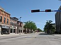
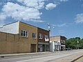
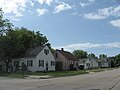
Gallery
-

-
 South Village Historical District
 -
 Adams Street
 -
 Nicolet Bank
 -
 Downtown Green Bay YMCA
 -
 The Broadway District
 -
 Large South Side home
 -
 South Washington Street on the near east side of Green Bay
 -
 The Northern Building
 -
 East Main Street in Green Bay
 -
 The east side of Green Bay
 -

-
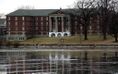 Burke Hall, St. Norbert College in De Pere, Wisconsin
 -
 Thome Fountain, in Green Bay Botanical Garden
 -
 Lambeau Field, home of the Green Bay Packers


Buildings
| Building | Year Built | Height | Floors |
|---|---|---|---|
| Lambeau Field | 1957 | 232 feet | N/A |
| St. Vincent Hospital | 1957 | 10 | |
| 400 Monroe Plaza | 10 | ||
| Bellin Building[34] | 1915 | 114 feet | 9 |
| Northland Hotel | 1924 | 98 feet | 9 |
| Bellin Hospital | 8 | ||
| Flats on the Fox | 2008 | 8 | |
| Hyatt on Main | 1984 | 8 | |
| Mason Manor | 8 | ||
| 425 Pine Street | 7 | ||
| Wisconsin Public Service | 7 | ||
| Clarion Hotel | 1973 | 7 | |
| YMCA | 1924 | 7 | |
| Green Bay State Office Building | 1983 | 6 |
Trivia
- Green Bay featured in the 1992 TV Show "Picket Fences", as being the point of origin of 400 school children to be bussed to Rome, Wisconsin.
- Green Bay has five nicknames: "Titletown", "Bayland", "Bay City", "Packerland", and "Packer City".
References
- ^ a b "US Gazetteer files 2010". United States Census Bureau. Retrieved 2012-11-18.
- ^ a b "American FactFinder". United States Census Bureau. Retrieved 2012-11-18.
- ^ "Population Estimates". United States Census Bureau. Retrieved 2013-06-24.
- ^ METROPOLITAN STATISTICAL AREAS AND COMPONENTS, Office of Management and Budget, 2007-05-11. Accessed 2008-07-30.
- ^ http://www.wisconsinhistory.org/dictionary/index.asp?action=view&term_id=2330&keyword=nicolet
- ^ City of Green Bay. "City of Green Bay." www.ci.green-bay.wi.us. 5 Oct. 2008 <http://www.ci.green-bay.wi.us/geninfo/history_o.html>
- ^ http://www.enchantedlearning.com/explorers/page/n/nicollet.shtml
- ^ a b Rodesch, Jerrold C. (1984). "Jean Nicolet". University of Wisconsin–Green Bay. Retrieved 2007-10-13.
- ^ City of Green Bay. "City of Green Bay." www.ci.green-bay.wi.us. 5 Oct. 2008 <http://www.ci.green-bay.wi.us/geninfo/history_o.html>
- ^ City of Green Bay. "City of Green Bay." www.ci.green-bay.wi.us. 5 Oct. 2008 <http://www.ci.green-bay.wi.us/geninfo/history_o.html>
- ^ City of Green Bay. "City of Green Bay." www.ci.green-bay.wi.us. 5 Oct. 2008 <http://www.ci.green-bay.wi.us/geninfo/history_o.html>
- ^ Warren Gerds, A is for architecture: Hazelwood stands out in Greek Revival style, Press-Gazette, July 16, 2009, Accessed July 16, 2009. [dead link]
- ^ City of Green Bay. "City of Green Bay." www.ci.green-bay.wi.us. 5 Oct. 2008 <http://www.ci.green-bay.wi.us/geninfo/history_o.html>
- ^ City of Green Bay. "City of Green Bay." www.ci.green-bay.wi.us. 5 Oct. 2008 <http://www.ci.green-bay.wi.us/geninfo/history_o.html>
- ^ Martin, Deborah Beaumont; Beaumont, Sophie (1899). Old Green Bay. New York: Cheltenham Press. Retrieved September 13, 2013.
- ^ City of Green Bay. "City of Green Bay." www.ci.green-bay.wi.us. 5 Oct. 2008 <http://www.ci.green-bay.wi.us/geninfo/history_o.html>
- ^ City of Green Bay. "City of Green Bay." www.ci.green-bay.wi.us. 5 Oct. 2008 <http://www.ci.green-bay.wi.us/geninfo/history_o.html>
- ^ City of Green Bay. "City of Green Bay." www.ci.green-bay.wi.us. 5 Oct. 2008 <http://www.ci.green-bay.wi.us/geninfo/history_o.html>
- ^ Mayor Denissen
- ^ M. Kottek, J. Grieser, C. Beck, B. Rudolf, & F.Rubel, "World Map of the Köppen-Geiger climate classification updated", Meteorologische Zeitschrift, Vol. 15, No. 3, 259-263 (June 2006).
- ^ a b c "NowData - NOAA Online Weather Data". National Oceanic and Atmospheric Administration. Retrieved 2011-12-27.
- ^ "Climatological Information for Green Bay, United States". Hong Kong Observatory. Retrieved 2010-10-27.
- ^ [1]
- ^ http://www.dot.wisconsin.gov/projects/state/connections2030.htm
- ^ http://www.newrails.org/
- ^ Brown County Library: General Information Accessed 23 October 2011
- ^ http://www.wisconsinpower.net/gb/
- ^ Ryman, Richard (October 12, 2007). "Broadway District businesses go Wi-Fi". Green Bay Press-Gazette. Retrieved 2007-12-09. [dead link]
- ^ "City of Green Bay 2010 Comprehensive Annual Financial Report" (PDF).
- ^ a b Will, Tracy (1997). Wisconsin. Oakland, California: Compass American Guides. p. 83. ISBN 1-878867-49-0.
- ^ ESPN.com, "There is no other TitleTown USA", April 10, 2008.
- ^ "W. J. Abrams (1829-1900)". City of Green Bay. Retrieved 2011-11-30.
- ^ Martin, Deborah Beaumont (1913). History of Brown County, Wisconsin: Past and Present, Volume 1. S.J. Clarke publishing Company. p. 270.
- ^ http://bellinbuilding.com/history_2.html
External links
- Official Green Bay, Wisconsin Website
- Official Website of the Green Bay Broadway District
- Greater Green Bay Convention & Visitor Bureau
- Green Bay Area Chamber of Commerce
- Green Bay Packers - American Football Team
- Belgian-American Research Collection
- Wisconsin Hometown Stories: Green Bay Documentary produced by Wisconsin Public Television
| Core city |  | |
|---|---|---|
| Largest municipalities over 10,000 in 2010 | ||
| Municipalities under 10,000 in 2010 | ||
| Counties | ||
Municipalities and communities of Brown County, Wisconsin, United States | ||
|---|---|---|
| Cities |  | |
| Villages | ||
| Towns | ||
| CDPs | ||
| Unincorporated communities |
| |
| Indian reservation | ||
| Ghost towns/ neighborhoods | ||
| Footnotes | ‡This populated place also has portions in an adjacent county or counties | |
- Cities in Brown County, Wisconsin
- Cities in Wisconsin
- Green Bay, Wisconsin
- Populated places on the Great Lakes
- Inland port cities and towns of the United States
- County seats in Wisconsin
- Green Bay Packers
- Green Bay metropolitan area
- Populated places established in 1634
- Belgian-American culture in Wisconsin
- French mission settlements in North America