
Kas Plateau Reserved Forest
| Kaas Plateau | |
|---|---|
| कास पठार | |
 Kaas Plateau | |
 Kaas Plateau | |
| Location | Satara, Maharashtra, India |
| Nearest city | Satara |
| Coordinates | 17°43′12″N 73°49′22″E / 17.72000°N 73.82278°E |
| Area | 10 km2 (3.9 sq mi) |
| Governing body | Ministry of Environment and Forests, Government of India |
| www | |
The Kaas Plateau, also known as the Kaas Pathar or Kas Sadas, is a plateau situated 25 kilometres west from Satara city in Maharashtra, India.[1][2] It falls under the Sahyadri Sub Cluster of the Western Ghats, and it became a part of a UNESCO World Natural Heritage Site in 2012.[3][4]
It is a biodiversity hotspot known for various types of seasonal wild flowers bloom and numerous species of endemic butterflies annually in the months of August and September.[4] The plateau is situated at an altitude of 1200 metres and is approximately 10 square kilometers in area.[2] Kaas has more than 850 different species of flowering plants of which 624 are listed on the IUCN Red List.[1] These include orchids, shrubs such as the Karvy, and carnivorous plants such as Drosera Indica.


About
Kaas plateau is a plateau located near Satara. It is situated high hill plateaus and grasslands turns into a 'valley of flowers' during monsoon season, particularly from August to early October. Kaas Plateau has more than 150 or more types of flowers, shrubs and grasses. The orchids bloom here for a period of 3–4 weeks during this season. Kaas plateau is a World Natural Heritage site.[5][6][7] To control possible damage by tourists, the number of visitors to the plateau has been restricted to 3,000 per day.[5][8] In September, some of the most common flowering plants are Eriocaulon manoharanii, Pogostemon deccanensis, Senecio grahamii, Impatiens oppositifolia and Dipcadi montanum.[9]
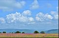
The plateau experiences a natural cycle of extreme conditions, with wet water-logged cool monsoons, very dry barren hot summer (45 C) and dry winter (5 C). The soil is a thin layer on top of Deccan rock, with varying quality of nutrients. The annual cyclic ecosystem here, and nearby similar but smaller lateritic plateaus, has adapted to these conditions.[10][2]
Geography
Kaas plateau is a plateau located around 25 km from Satara. There are two ways to reach Kaas. one the more direct way from Satara and another from Tapola via the link road connecting Mahabaleshwar and Panchgani to Kas Pathar. Kas plateau is 20 km away from Northern part of Koyana Sanctuary. The major portion of the plateau is reserve Forest. Kaas lake (built 100 years ago) is a perennial source of Water supply for western part of Satara city by gravity. The flora of Kaas are around the locality of that area. The plateau is largely formed of basalt which is directly exposed to atmosphere. The basalt rock is covered by a thin cover of soil formed due to erosion and has accumulated a layer of not more than an inch or so. This soil is neither black nor lateritic. At certain places water gets accumulated because of uneven surface. The plants growing on Kas plateau are typically of herbaceous nature of like grasses. The small shrubs and trees are located at the periphery of the plateau at Kaas plateau.[8]
The various distances of Kas plateau are as follows:
- From Satara - 25 km
- From Pune - 125 km
- From Mumbai - 280 km
- From Kolhapur - 150 km
Bio-diversity on Kaas plateau
Kaas Plateau is rich in its Bio-diversity. Many species are observed on plateau which are new to the Botanical Science. Many of the endemic, endangered plants are found on Plateau. More than 850 species of flowering plants are reported on the plateau. 624 species have entered in the Red Data Book. Out of these 624 species, 39 are found only in Kaas Region.[11]
Other attractions
Kaas lake is on the south of the Kaas Plateau and is surrounded by dense forest. It lies between Sajjangad fort and the Kanher Dam. Koyna project is around 30 km towards the south of Kaas Lake.[12] Vajrai Waterfall is also near from Kaas which is India's highest waterfall.[13]
Flowers
The following is a list of some of the flowers found on at Kaas:
Gallery
-
 Monsoon flowers
 -
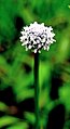 Kaas Flowers
 -
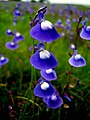 Utricularia arcuata at Kaas
 -
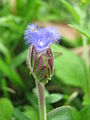 Kaas Flowers
 -
 Kaas Flowers


References
- ^ a b Kas plateau official website
- ^ a b c Herbaceous vegetation of threatened high altitude lateritic plateau ecosystems of Western Ghats, southwestern Maharashtra, India, M.M. Lekhak and S.R. Yadav (2012), Rheedea
- ^ India’s Western Ghats gets World Natural Heritage Status, Also see: Newsletter, UNESCO New Delhi, Volume 5, Issue 3, July - Sept. 2014
- ^ a b BUTTERFLIES OF KAAS VALLEY, MAHARASHTRA, INDIA, Suresh Kumar Shah, Bulganin Mitra (2015), Zoological Survey of India
- ^ a b "Kaas to bloom for only 2,000 tourists daily - Pune -DNA". Dnaindia.com. Retrieved 1 May 2013.
- ^ "Mr. Rajendra Shende, Chairman, TERRE, United Nations Environment Programme, Technologies and Policies, Ozon Action Programme, Multilateral Ozone Fund, Global Environmental Facility, Technology support programme, Multilateral Environmental Agreement, Intergovernmental Panel on Climate Change, Indian Institute of Technology". Terrepolicycentre.org. 15 April 2013. Retrieved 1 May 2013.
- ^ "Articles about World Heritage List by Date - Page 5 - Times Of India". Articles.timesofindia.indiatimes.com. Retrieved 1 May 2013.
- ^ a b [1]
- ^ Biodiversity of Arbuscular Mycorrhizal fungi in Kaas plateau, Satara, Maharashtra, India, Chahar Sunita and Jain Shweta (2015)
- ^ A NEW SPECIES OF THE TRAPDOOR SPIDERS Mirza et al (2012), page 12
- ^ Bio-diversity on Kaas plateau
- ^ Other attractions
- ^ Vajrai Waterfall
External links
- Website by the Satara division forest department
Satara district topics | ||
|---|---|---|
| History | .svg) | |
| Battles | ||
| Rivers | ||
| Dams | ||
| Lakes | ||
| Ghats | ||
| Caves | ||
| Cities and towns | ||
| Villages | ||
| Places to see | ||
| Monuments | ||
| Transport | ||
| Education | ||
| Lok Sabha constituencies | ||
| Vidhan Sabha constituencies | ||
| Culture | ||
| Topics | |||||||||||||
|---|---|---|---|---|---|---|---|---|---|---|---|---|---|
| Regions | |||||||||||||
| Divisions and Districts |
| ||||||||||||
| Million-plus cities in Maharashtra | |||||||||||||
| Other cities with municipal corporations | |||||||||||||
| Government | |||||||||||||