[ 3] Name on the Register[ 4]
Image
Date listed[ 5]
Location
City or town
Description
1
Alpha Tau Omega Fraternity House Alpha Tau Omega Fraternity House March 20, 2002 (#02000197 ) 314 Russell St. 40°25′39″N 86°55′07″W / 40.4275°N 86.918611°W / 40.4275; -86.918611 (Alpha Tau Omega Fraternity House ) West Lafayette
2
Jesse Andrew House Jesse Andrew House August 11, 1983 (#83000103 ) 123 Andrew Pl. 40°25′28″N 86°54′34″W / 40.424444°N 86.909444°W / 40.424444; -86.909444 (Jesse Andrew House ) West Lafayette
3
Archeological Sites 12T59 and 12T530 Upload image September 14, 2015 (#15000599 ) Southern side of Indian Mound Dr.[ 6] 40°31′23″N 86°47′30″W / 40.523056°N 86.791667°W / 40.523056; -86.791667 (Archeological Sites 12T59 and 12T530 ) Tippecanoe Township
4
Judge Cyrus Ball House Judge Cyrus Ball House May 3, 1984 (#84001649 ) 402 S. 9th St. 40°24′49″N 86°53′12″W / 40.413611°N 86.886667°W / 40.413611; -86.886667 (Judge Cyrus Ball House ) Lafayette
5
Battle Ground Historic District Battle Ground Historic District July 23, 1985 (#85001639 ) Roughly bounded by Burnett Creek, Sherman Dr., and an open ridge on the southeast 40°30′35″N 86°50′21″W / 40.509722°N 86.839167°W / 40.509722; -86.839167 (Battle Ground Historic District ) Battle Ground
6
Big Four Depot Big Four Depot June 22, 2003 (#03000548 ) 200 N. 2nd St. 40°25′07″N 86°53′44″W / 40.418611°N 86.895556°W / 40.418611; -86.895556 (Big Four Depot ) Lafayette
7
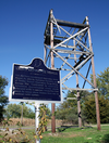
Cairo Skywatch Tower Cairo Skywatch Tower March 21, 2002 (#02000202 ) County Road 850N at County Road 100W at Cairo 40°32′26″N 86°55′30″W / 40.540694°N 86.925°W / 40.540694; -86.925 (Cairo Skywatch Tower ) Tippecanoe Township
8
Centennial Neighborhood District Centennial Neighborhood District June 16, 1983 (#83003443 ) Roughly bounded by Union, 3rd, 4th, Ferry, and 9th Sts. 40°25′21″N 86°53′25″W / 40.4225°N 86.890278°W / 40.4225; -86.890278 (Centennial Neighborhood District ) Lafayette
9
Chauncey-Stadium Avenues Historic District Chauncey-Stadium Avenues Historic District December 20, 2002 (#02001558 ) Roughly bounded by Meridian, Lincoln, River Rd., Fowler, Quincy, Northwestern, and Allen Sts. 40°25′52″N 86°54′22″W / 40.431111°N 86.906111°W / 40.431111; -86.906111 (Chauncey-Stadium Avenues Historic District ) West Lafayette
10
John E. and Catherine E. Christian House John E. and Catherine E. Christian House June 16, 1992 (#92000679 ) 1301 Woodland Ave. 40°26′18″N 86°54′59″W / 40.438333°N 86.916389°W / 40.438333; -86.916389 (John E. and Catherine E. Christian House ) West Lafayette
11
Curtis-Grace House Curtis-Grace House April 10, 2012 (#12000190 ) 2175 Tecumseh Park Ln. 40°26′50″N 86°54′27″W / 40.447222°N 86.907500°W / 40.447222; -86.907500 (Curtis-Grace House ) West Lafayette
12
Dayton Historic District Dayton Historic District March 26, 2003 (#03000142 ) Roughly bounded by Walnut, Harrison, and Pennsylvania Sts. 40°22′35″N 86°46′03″W / 40.376389°N 86.7675°W / 40.376389; -86.7675 (Dayton Historic District ) Dayton
13
Downtown Lafayette Historic District Downtown Lafayette Historic District November 28, 1980 (#80000067 ) Roughly bounded by 2nd, Ferry, 6th, and South Sts. 40°25′08″N 86°53′33″W / 40.418889°N 86.8925°W / 40.418889; -86.8925 (Downtown Lafayette Historic District ) Lafayette
14
Ellsworth Historic District Ellsworth Historic District December 30, 1986 (#86003501 ) Roughly bounded by Columbia, the Norfolk Southern railroad tracks, Alabama, 7th, South, and 6th Sts. 40°24′55″N 86°53′20″W / 40.415278°N 86.888889°W / 40.415278; -86.888889 (Ellsworth Historic District ) Lafayette
15
Ely Homestead Ely Homestead October 8, 1976 (#76000036 ) 4106 E. 200N, northeast of Lafayette 40°26′53″N 86°49′37″W / 40.448056°N 86.826944°W / 40.448056; -86.826944 (Ely Homestead ) Fairfield Township
16
Enterprise Hotel Enterprise Hotel June 21, 1984 (#84001650 ) 1015 Main St. 40°25′08″N 86°53′06″W / 40.418889°N 86.885°W / 40.418889; -86.885 (Enterprise Hotel ) Lafayette
17
Falley Home Falley Home July 15, 1982 (#82000078 ) 601 New York St. 40°24′52″N 86°53′24″W / 40.414444°N 86.89°W / 40.414444; -86.89 (Falley Home ) Lafayette
18
Farmers Institute Farmers Institute March 27, 1986 (#86000609 ) 4626 W. County Road 660S; also 4636 West 660 South 40°19′18″N 86°59′29″W / 40.321667°N 86.991389°W / 40.321667; -86.991389 (Farmers Institute ) Shadeland Second address represents a boundary increase approved March 6, 2020
19
Fort Ouiatenon Fort Ouiatenon February 16, 1970 (#70000008 ) Along River Rd. and the Wabash River , west of the Purdue University Airport [ 7] 40°24′23″N 86°57′50″W / 40.4064°N 86.9639°W / 40.4064; -86.9639 (Fort Ouiatenon ) Wabash Township Designated a National Historic Landmark in 2021.
20
Moses Fowler House Moses Fowler House August 5, 1971 (#71000009 ) Corner of 10th and South Sts. 40°25′00″N 86°53′10″W / 40.416667°N 86.886111°W / 40.416667; -86.886111 (Moses Fowler House ) Lafayette
21
Greenbush Cemetery Upload image May 26, 2021 (#100006569 ) 1408 North 12th St. 40°25′53″N 86°53′04″W / 40.4315°N 86.8845°W / 40.4315; -86.8845 (Greenbush Cemetery ) Lafayette
22
Happy Hollow Heights Historic District Happy Hollow Heights Historic District December 15, 2015 (#15000891 ) 1821 and 1809 Happy Hollow Rd. and all houses on Laurel, Hollowood, Fearnleaf, and Sumac Drs. 40°26′33″N 86°54′00″W / 40.442500°N 86.900000°W / 40.442500; -86.900000 (Happy Hollow Heights Historic District ) West Lafayette
23
Hershey House Hershey House November 28, 1978 (#78000054 ) East of Lafayette on East Rd. 40°26′42″N 86°45′59″W / 40.445°N 86.766389°W / 40.445; -86.766389 (Hershey House ) Perry Township
24
Highland Park Neighborhood Historic District Highland Park Neighborhood Historic District March 14, 1996 (#96000270 ) Roughly bounded by Kossuth St., S. 9th St., Cherokee Ave., and 4th St. 40°24′22″N 86°53′21″W / 40.406111°N 86.889167°W / 40.406111; -86.889167 (Highland Park Neighborhood Historic District ) Lafayette
25
Hills and Dales Historic District Hills and Dales Historic District June 27, 2002 (#02000689 ) Roughly bounded by Northwestern Ave., Meridian St., Hillcrest Rd., and Grant St. 40°26′07″N 86°54′49″W / 40.435278°N 86.913611°W / 40.435278; -86.913611 (Hills and Dales Historic District ) West Lafayette
26
David and Harriet Hopwood House Upload image November 15, 2024 (#100011039 ) 602 N. Fifth Street 40°25′22″N 86°53′31″W / 40.4229°N 86.8920°W / 40.4229; -86.8920 (David and Harriet Hopwood House ) Lafayette
27
Indian Trail Road-Belle River Bridge Indian Trail Road-Belle River Bridge January 28, 2000 (#00000012 ) Steel Bridge Research, Inspection, Training and Engineering Center, S. Sharon Chapel Rd. 40°24′31″N 86°57′02″W / 40.40875°N 86.950556°W / 40.40875; -86.950556 (Indian Trail Road-Belle River Bridge ) Wabash Township Replaced in 2008, this bridge was moved from its original location and as of 2015 resides at Purdue University 's Steel Bridge Research, Inspection, Training and Engineering Center.[ 8]
28
Indiana State Soldiers Home Historic District Indiana State Soldiers Home Historic District January 2, 1974 (#74000034 ) North of Lafayette off State Road 43 40°28′08″N 86°53′15″W / 40.468889°N 86.8875°W / 40.468889; -86.8875 (Indiana State Soldiers Home Historic District ) Tippecanoe and Wabash Townships
29
Jefferson Historic District Jefferson Historic District September 16, 2001 (#01000976 ) Roughly bounded by 9th, Erie, Elizabeth, and Ferry Sts. 40°25′19″N 86°53′04″W / 40.421944°N 86.884444°W / 40.421944; -86.884444 (Jefferson Historic District ) Lafayette
30
Marian Apartments Marian Apartments June 30, 1983 (#83000150 ) 615 North St. 40°25′15″N 86°53′23″W / 40.420833°N 86.889722°W / 40.420833; -86.889722 (Marian Apartments ) Lafayette
31
Mars Theatre Mars Theatre January 26, 1981 (#81000030 ) 11 N. 6th St. 40°25′06″N 86°53′25″W / 40.418333°N 86.890278°W / 40.418333; -86.890278 (Mars Theatre ) Lafayette
32
Levi and Lucy Morehouse Farm Levi and Lucy Morehouse Farm December 19, 2012 (#12001065 ) 5038 Morehouse Rd., northwest of West Lafayette 40°29′27″N 86°57′26″W / 40.490833°N 86.957222°W / 40.490833; -86.957222 (Levi and Lucy Morehouse Farm ) Wabash Township
33
Morton School Morton School September 9, 1999 (#99001113 ) 222 N. Chauncey Ave. 40°25′31″N 86°54′23″W / 40.425278°N 86.906389°W / 40.425278; -86.906389 (Morton School ) West Lafayette
34
Ninth Street Hill Neighborhood Historic District Ninth Street Hill Neighborhood Historic District April 14, 1997 (#97000303 ) Roughly 9th St. from South to Kossuth Sts. and State St. from 9th to Kossuth Sts. 40°24′48″N 86°53′09″W / 40.413333°N 86.885833°W / 40.413333; -86.885833 (Ninth Street Hill Neighborhood Historic District ) Lafayette
35
Park Mary Historic District Park Mary Historic District June 15, 2001 (#01000617 ) Roughly bounded by Union, Hartford, N. 6th, and N. 14th Sts. 40°25′33″N 86°53′01″W / 40.425833°N 86.883611°W / 40.425833; -86.883611 (Park Mary Historic District ) Lafayette
36
Oliver Webster Jr. and Catherine Peirce House Upload image December 3, 2018 (#100003190 ) 538 S. 7th St. 40°24′38″N 86°53′18″W / 40.4106°N 86.8883°W / 40.4106; -86.8883 (Oliver Webster Jr. and Catherine Peirce House ) Lafayette
37
Perrin Historic District Perrin Historic District September 10, 1979 (#79000045 ) Roughly bounded by Murdock Park, Sheridan Rd., Columbia, Main, and Union Sts. 40°25′14″N 86°52′47″W / 40.420556°N 86.879722°W / 40.420556; -86.879722 (Perrin Historic District ) Lafayette
38
James Pierce Jr. House James Pierce Jr. House June 17, 1982 (#82000079 ) 4624 N. 140W, north of West Lafayette 40°29′06″N 86°55′56″W / 40.485°N 86.932222°W / 40.485; -86.932222 (James Pierce Jr. House ) Wabash Township
39
William Potter House William Potter House January 6, 1983 (#83000104 ) 915 Columbia St. 40°25′05″N 86°53′08″W / 40.418056°N 86.885556°W / 40.418056; -86.885556 (William Potter House ) Lafayette
40
St. John's Episcopal Church St. John's Episcopal Church September 20, 1978 (#78000055 ) 315 N. 6th St. 40°25′13″N 86°53′25″W / 40.420278°N 86.890278°W / 40.420278; -86.890278 (St. John's Episcopal Church ) Lafayette
41
St. Mary Historic District St. Mary Historic District June 14, 2001 (#01000622 ) Roughly bounded by Main, South, 10th, and 14th Sts. 40°25′01″N 86°52′51″W / 40.416944°N 86.880833°W / 40.416944; -86.880833 (St. Mary Historic District ) Lafayette
42
Scott Street Pavilion Scott Street Pavilion September 27, 1984 (#84001656 ) Columbian Park 40°24′54″N 86°52′18″W / 40.415°N 86.871667°W / 40.415; -86.871667 (Scott Street Pavilion ) Lafayette
43
Spring Vale Cemetery Upload image August 25, 2020 (#100005512 ) 2580 Schuyler Avenue 40°26′54″N 86°51′38″W / 40.4482°N 86.8605°W / 40.4482; -86.8605 (Spring Vale Cemetery ) Lafayette
44
Stidham United Methodist Church Stidham United Methodist Church November 27, 1992 (#92001651 ) 5300 S. 175W 40°20′30″N 86°56′17″W / 40.3417°N 86.9381°W / 40.3417; -86.9381 (Stidham United Methodist Church ) Shadeland
45
Temple Israel Temple Israel February 19, 1982 (#82000080 ) 17 S. 7th St. 40°25′00″N 86°53′16″W / 40.4167°N 86.8878°W / 40.4167; -86.8878 (Temple Israel ) Lafayette
46
Tippecanoe Battlefield Tippecanoe Battlefield October 15, 1966 (#66000013 ) 7 miles northeast of Lafayette on State Road 25 40°28′08″N 86°50′43″W / 40.4689°N 86.8453°W / 40.4689; -86.8453 (Tippecanoe Battlefield ) Battle Ground and Tippecanoe Township
47
Tippecanoe County Courthouse Tippecanoe County Courthouse October 31, 1972 (#72000013 ) Public Square 40°25′05″N 86°53′20″W / 40.4181°N 86.8889°W / 40.4181; -86.8889 (Tippecanoe County Courthouse ) Lafayette
48
Upper Main Street Historic District Upper Main Street Historic District May 24, 1990 (#90000814 ) Roughly bounded by Ferry St., 6th St., Columbia St., and the Norfolk Southern railroad tracks 40°25′09″N 86°53′14″W / 40.4192°N 86.8872°W / 40.4192; -86.8872 (Upper Main Street Historic District ) Lafayette
49
The Varsity The Varsity December 7, 2001 (#01001342 ) 101 Andrew Place 40°25′27″N 86°54′33″W / 40.4242°N 86.9092°W / 40.4242; -86.9092 (The Varsity ) West Lafayette
50
Waldron-Beck House and Carriage House Waldron-Beck House and Carriage House February 9, 1984 (#84001661 ) 829 N. 21st St. 40°25′33″N 86°52′21″W / 40.4258°N 86.8725°W / 40.4258; -86.8725 (Waldron-Beck House and Carriage House ) Lafayette
51
James H. Ward House James H. Ward House April 7, 1988 (#88000385 ) 1116 Columbia St. 40°25′06″N 86°53′02″W / 40.4183°N 86.8839°W / 40.4183; -86.8839 (James H. Ward House ) Lafayette


