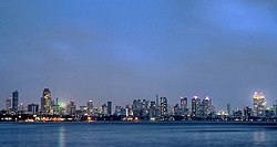
Worli
This article has multiple issues. Please help improve it or discuss these issues on the talk page. (Learn how and when to remove these template messages)
|
Worli | |
|---|---|
Neighbourhood | |
 | |
| Coordinates: 19°00′00″N 72°48′54″E / 19.00°N 72.815°E | |
| Country | India |
| State | Maharashtra |
| District | Mumbai City |
| City | Mumbai |
| Government | |
| • Type | Municipal Corporation |
| • Body | Brihanmumbai Municipal Corporation (MCGM) |
| Languages | |
| • Official | Marathi |
| Time zone | UTC+5:30 (IST) |
| PIN | 400018 and 400030 |
| Area code | 022 |
| Vehicle registration | MH 01 |
| Civic agency | BMC |

Worli is a locality in South Mumbai, Maharashtra. The sea connects it with Bandra (closest suburb) via the Bandra-Worli Sea Link. Historic spellings include Warli, Worlee, Varli, and Varel.[1] Originally Worli was a separate island, one of the Seven Islands of Bombay which were ceded by the Portuguese to England in 1661; it was linked up with the other islands in the 19th Century.
See also
References
- ^ D'Cunha, Jose Gerson (1900). "IV The Portuguese Period". The Origins of Bombay (3 ed.). Bombay: Asian Educational Services. p. 265. ISBN 81-206-0815-1. Retrieved 4 January 2009.

