Titel
Titel
Тител | |
|---|---|
Town and municipality | |
 Panorama view of Titel, seen from Titel Hill | |
 Location of the municipality of Titel within Serbia | |
| Coordinates: 45°12′N 20°18′E / 45.200°N 20.300°E | |
| Country | |
| Province | Vojvodina |
| District | South Bačka |
| Settlements | 6 |
| Government | |
| • Mayor | Milivoj Petrović |
| Area | |
| • Municipality | 262 km2 (101 sq mi) |
| Population (2011 census)[2] | |
| • Town | 5,247 |
| • Municipality | 15,738 |
| Time zone | UTC+1 (CET) |
| • Summer (DST) | UTC+2 (CEST) |
| Postal code | 21240 |
| Area code | +381 21 |
| Car plates | NS |
| Website | www |


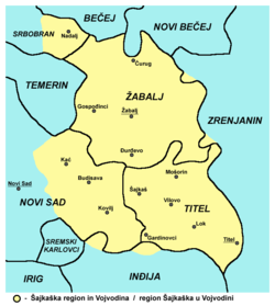
Titel (Serbian Cyrillic: Тител) is a town and municipality located in the South Bačka District of the autonomous province of Vojvodina, Serbia. The town of Titel has a population of 5,247, while the population of the municipality of Titel is 15,738. It is located in southeastern part of the geographical region of Bačka, known as Šajkaška.
Name
In Serbian, the town is known as Titel (Тител), in Hungarian as Titel, in German as Titel (and sometimes Theisshügel), and in Latin as Titulium.
History
The Titel Plateau is an elevated region between the Danube and Tisza rivers, close to the confluence; about 16 by 7 kilometres (9.9 by 4.3 miles); roughly 80 square kilometres (31 square miles). It has an ellipsoid form and is characterized by steep slopes at the margins. It has a substantial loess cover and is often called the Titel Loess Plateau; the loess on the plateau is considered to contain the most detailed terrestrial palaeoclimate records in Europe, with a thick and apparently continuous record extending to the middle and late Early Pleistocene.[3] It represents a major archaeological site at the Danube-Tisza confluence with prehistoric and ancient findings.[4]
Early medieval sources are scarce. Slavs are mentioned in the area in the late 7th and early 8th century, while Magyars (Hungarians) settled the Pannonian Plain in 896, already in the next century holding the Tisa-Danube confluence. Grand Prince Árpád (r. 895–907) is believed to have defeated the Bulgars (Salan) at Titel. Titel was an important strategical location, and was included in the Bács County. Ladislaus I of Hungary (r. 1077–95) and his brother Lampert founded an Augustinian monastery here. On 17 October 1389 a Clement was inscribed at the Vienna University, who in Titel taught reading and cantillation. In 1439 Albert II's army awaited in Titel military aid from the county to help Đurađ Branković defend Smederevo, but the aid never arrived.[5]
From 1526, the town was part of the Ottoman Empire. According to the first Ottoman census from 1546, the town had 87 houses, of which most were Serb, three were Croat, one Hungarian, and one Vlach. The duke of the town was Vuk Radić. That census recorded that five of the citizens were immigrants, meaning that others lived there before Ottomans conquered the town.
In the outset of the Ottoman rule, the town had one Orthodox and one Catholic church. In the first quarter of the 17th century, the town had three mosques, two tekkes and three medreses.
From 1699, the town was part of the Habsburg Monarchy. It was included in the Habsburg Military Frontier. Between 1750 and 1763, the town was under civil administration (in the Batsch-Bodrog County of the Habsburg Kingdom of Hungary), until it was returned to the jurisdiction of the Military Frontier (Šajkaš Battalion).
In 1848 and 1849, Titel was part of Serbian Vojvodina, a Serb autonomous region within the Habsburg Empire. Between 1849 and 1872, it was again part of the Military Frontier, and after 1872, it came under civil administration as a part of the Bács-Bodrog County within the Habsburg Kingdom of Hungary (part of Austria-Hungary).
After 1918, the town became part of the Kingdom of Serbs, Croats and Slovenes and subsequent South Slavic states. During the World War II Hungarian occupation, in a 1942 raid, 51 inhabitants of the town were murdered, of whom 45 were men, 1 child, and 5 old people. By nationality, victims included 49 Serbs, and 1 Jew.
Inhabited places
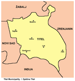
Titel municipality encompasses the town of Titel, and the following villages:
Ethnic groups (2011 census)
The total population of the Titel municipality was 15,738, including:[6]
- 13,615 Serbs (86.51%)
- 822 Hungarians (5.22%)
- 264 Romani (1.68%)
- 1037 other and undeclared.
All settlements in the municipality have an ethnic Serb majority.
Historical population of the town
- 1961: 5,717
- 1971: 5,957
- 1981: 6,227
- 1991: 6,007
Politics
Seats in the municipal parliament won in the 2004 local elections: [1]
- Democratic Party (8)
- Serbian Radical Party (7)
- Socialist Party of Serbia (3)
- Democratic Party of Serbia (2)
- Citizens' Association - Zdenko Babić (2)
- Strength of Serbia Movement (2)
- Serbian Renewal Movement (1)
Notable people
- Svetozar Miletić (1826–1901), advocate, politician, mayor of Novi Sad, the political leader of Serbs in Vojvodina. He was born in the village Mošorin in Titel municipality.
- Mileva Marić (1875–1948), Serbian mathematician, and Albert Einstein's first wife. She was born in Titel.
- Isidora Sekulić (1877–1958), writer. She was born in the village of Mošorin in the Titel municipality.
- Dušan Popov, Serb Double Agent, on whom author Ian Fleming based his character James Bond.
- Dragomir Lalin (1924-2013), was born in Titel. He was a Serbian dissident, under the regime of Josip Broz Tito. Dragomir Lalin was the founder of Milan Vidak wire factory and Garant auto engine parts factory in Futog.
Gallery
-
Aerial view
-
Orthodox Church in Titel
-
Catholic Church in Titel
-
Abandoned church in Titel
See also
- Šajkaška
- South Bačka District
- List of places in Serbia
- List of cities, towns and villages in Vojvodina
- Municipalities of Serbia
References
- ^ "Municipalities of Serbia, 2006". Statistical Office of Serbia. Retrieved 2010-11-28.
- ^ "2011 Census of Population, Households and Dwellings in the Republic of Serbia: Comparative Overview of the Number of Population in 1948, 1953, 1961, 1971, 1981, 1991, 2002 and 2011, Data by settlements" (PDF). Statistical Office of Republic Of Serbia, Belgrade. 2014. ISBN 978-86-6161-109-4. Retrieved 2014-06-27.
- ^ Belij,S. et al 2009. Geomorphological geoheritage sites of the Titel Loess Plateau. LoessFest'09 Novi Sad abstracts
- ^ http://spomenicikulture.mi.sanu.ac.rs/spomenik.php?id=696.
{{cite web}}: Missing or empty|title=(help) - ^ Republika. Vol. 10. Udruženje za jugoslovensku demokratsku inicijativu. 1998. p. 16.
- ^ "Population by ethnicity – Titel". Statistical Office of the Republic of Serbia (SORS). Retrieved 23 February 2013.
Sources
- Marko Jovanov, Devet vekova od pomena imena Titela, Titelski letopis, Titel, 2001
External links
- Official presentation of Titel municipality
- Official presentation of Titel Local Community
- Ravnica magazine - Titel Current Local News


