Logar Province: Difference between revisions
User Ketabtoon again have used sources that did not even mentioned a single word about the numbers of the ethnicities of Logar. Admins, please take self a look. Ketabtoon vandalizes and falsyfies sour |
|||
| Line 88: | Line 88: | ||
*[http://www.nps.edu/Programs/CCS/Docs/PDF%20Maps/NewTribal/Logar.pdf Tribal Map of Logar province on nps.edu] |
*[http://www.nps.edu/Programs/CCS/Docs/PDF%20Maps/NewTribal/Logar.pdf Tribal Map of Logar province on nps.edu] |
||
*[http://medlem.spray.se/afghan/ Afghan Sweden Online ] |
*[http://medlem.spray.se/afghan/ Afghan Sweden Online ] |
||
*[http://www.mrrd.gov.af/nabdp/Provincial%20Profiles/Logar%20PDP%20Provincial%20profile.pdf Logar provincial profile] |
|||
{{Provinces of Afghanistan}} |
{{Provinces of Afghanistan}} |
||
{{Districts of Logar}} |
{{Districts of Logar}} |
||
Revision as of 17:39, 9 August 2010
Logar (Pashto: لوګر, Persian: لوگَر) is one of the 34 provinces of Afghanistan. The word of Logar is built from two Pashto words: Loy (لوى "great") and Ghar (غر "mountain")[1]. It is located in the eastern zone, southeast of Kabul, and the geography of the province centers on the large Logar River which enters the province through the west and leaves to the north. Its capital is Pul-i-Alam. Logar has a mixed Pashtun and Tajik populaiton.
Politics
Logar is a generally religiously conservative province, although not to the extent of its southern neighbours. The province's political history is a microcosm of Afghanistan's recent turbulent past. During the period immediately prior to the US invasion of 2001, portions of the province were controlled by both the Taliban and the Northern Alliance. During the Jihad against Soviet occupation in the 1980s, Baraki Barak, Khushi, Charkh and Pule Alam districts were controlled by Jamiat e-Islami. Logar was known among Afghans as باب الجهاد' Bab al-Jihad', or 'the Gates of Jihad' because it became a fierce theatre of war between Mujahideen groups and the Soviet army and it was the main supply route of Mujahideen coming from south and Pakistan and going towards Northern and Central Afghanistan. It is said that the largest single convoy of the Soviets, consisting of more than 350 tanks, trucks, Oil Tankers and other vehicles, was attacked and destroyed in Logar province in a combined operation of different Mujahideen factions.[citation needed]
Geography

Logar can be generally described as a relatively flat river valley in the north and central regions, surrounded by rugged mountains to the east, south, and southwest. The district of Azra, in the east, consists almost entirely of mountains, while travel to the Paktia Province to the south is limited to the Tera Pass, a 2896 m high road that was recently completed as part of the international reconstruction effort in Afghanistan.
Although the government of Afghanistan recognizes the Azra district as being in Logar, many widely-accepted maps include it in the Paktia province to the south.
Capital

Logar's capital is the city of Pul-i-Alam, located in the district of the same name. It sits on the main road running from Kabul south to Gardez and Khowst province, which borders Pakistan.
Pul-i-Alam has seen a significant amount of reconstruction since the fall of the Taliban. The main road to Kabul was completed in 2006, significantly reducing travel time to the national capital. Additional projects include numerous schools, radio stations, government facilities, and a major Afghan National Police base situated just south of the city.
Like most Afghan cities, there is little municipal planning or services. Electricity is provided by diesel generators, and wells are the primary source of drinking water.
Education
The overall literacy rate in Logar province is 21%, however, while nearly one-third (31%) of men are literate this is true for just under one-tenth (9%) of women. There around 168 primary and secondary schools in the province catering for 81.538 students. There are nearly 2.082 teachers working in schools in the Logar province. [2]
Demographics
The population of Logar is mixed. Till today, there was no provincial census. In Logar live Pashtuns, Tajiks, Hazaras, some Sikhs and Jat people.
Districts

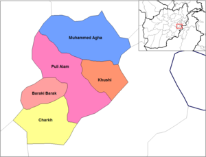
Until 2005 the district was administratively subdivided into five districts. In that year the province gained Azra District from neighbouring Paktia Province; also part of Charkh District was split off into the new district of Kharwar.
| District | Capital | Population[3] | Area[4] | Notes |
|---|---|---|---|---|
| Azra | 14,550 | Shifted from Paktia Province in 2005 | ||
| Baraki Barak | 78,063 | Includes the road linking Pul-i-Alam with Highway 1 to the west | ||
| Charkh | 40,492 | Sub-divided in 2005 | ||
| Kharwar | 26,607 | Created in 2005 within Charkh District | ||
| Khoshi | 15,127 | Home to one of the few Shiite enclaves in southeast Afghanistan | ||
| Mohammad Agha | 58,979 | The northern portion of Mohammad Agha is contiguous with the southern 'suburbs' of Kabul | ||
| Pul-i-Alam | 88,886 | Includes the capital city |
Sport
Cricket is growing in popularity in Logar Province. The province is represented in domestic cricket competitions by the Logar Province cricket team. The national team contains several players from the province.
References
- ^ http://www.logarweb.com/index.php?option=com_content&view=article&id=92
- ^ Cite error: The named reference
mrrdwas invoked but never defined (see the help page). - ^ http://www.mrrd.gov.af/nabdp/Provincial%20Profiles/Logar%20PDP%20Provincial%20profile.pdf Logar Provincial Profile - MRRD
- ^ Afghanistan Geographic & Thematic Layers
