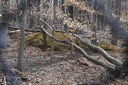
"A" Fort and Battery Hill Redoubt-Camp Early
Appearance
"A" Fort and Battery Hill Redoubt-Camp Early | |
 Traces of Confederate redoubts and trenches are visible | |
| Location | Balmoral Greens Ave., 1 mile (1.6 km) south of the junction with Compton Rd., near Manassas Park, Virginia |
|---|---|
| Coordinates | 38°47′22″N 77°25′40″W / 38.78944°N 77.42778°W |
| Area | 25 acres (10 ha) |
| Built | 1862 |
| NRHP reference No. | 98001315[1] |
| VLR No. | 029-5006 |
| Significant dates | |
| Added to NRHP | October 30, 1998 |
| Designated VLR | June 17, 1998[2] |
"A" Fort and Battery Hill Redoubt-Camp Early, also known as Measles Fort, is a historic American Civil War military facility and redoubt located near Manassas Park, Prince William County, Virginia.
It was listed on the National Register of Historic Places in 1998.[1]
References
- ^ a b "National Register Information System – "A" Fort and Battery Hill Redoubt--Camp Early (#98001315)". National Register of Historic Places. National Park Service. July 9, 2010.
- ^ "Virginia Landmarks Register". Virginia Department of Historic Resources. Archived from the original on 21 September 2013. Retrieved 5 June 2013.
Categories:
- Forts on the National Register of Historic Places in Virginia
- Government buildings completed in 1862
- National Register of Historic Places in Fairfax County, Virginia
- Forts in Virginia
- 1862 establishments in Virginia
- American Civil War on the National Register of Historic Places
- Northern Virginia Registered Historic Place stubs
- Fairfax County, Virginia geography stubs


