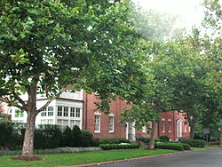
Robert E. Lee Boyhood Home
Appearance
Robert E. Lee Boyhood Home | |
 Robert E. Lee Boyhood Home, seen from the street | |
| Location | 607 Oronoco St., Alexandria, Virginia |
|---|---|
| Coordinates | 38°48′35″N 77°2′44″W / 38.80972°N 77.04556°W |
| Area | less than one acre |
| Built | 1795 |
| Architectural style | Federal |
| NRHP reference No. | 86001228[1] |
| VLR No. | 100-0082 |
| Significant dates | |
| Added to NRHP | June 05, 1986 |
| Designated VLR | December 17, 1985[2] |
The Robert E. Lee Boyhood Home is an historic house at 607 Oronoco Street, Alexandria, Virginia. It served in the early 1800s as the home of Anne Hill Carter Lee and her family, including the eponymous Robert. It should not be confused with the Lee-Fendall House, which is located at 614 Oronoco St.
History
It was the home of William Fitzhugh, and George Washington dined there. Marquis de Lafayette visited in 1824.
It was named a Virginia Historic Landmarks in 1968. It was added to the National Register of Historic Places in 1986. In 2000, it was sold to Mark Kington.[3]
References
- ^ "National Register Information System". National Register of Historic Places. National Park Service. March 13, 2009.
- ^ "Virginia Landmarks Register". Virginia Department of Historic Resources. Retrieved 2013-05-12.
- ^ "Robert E. Lee's Childhood Home Is Sold". The New York Times. 12 March 2000. Retrieved 15 December 2015.
External links
![]() Media related to Robert E. Lee Boyhood Home at Wikimedia Commons
Media related to Robert E. Lee Boyhood Home at Wikimedia Commons
- Potts-Fitzhugh House, 607 Oronoco Street, Alexandria, Independent City, VA at the Historic American Buildings Survey (HABS)
- http://www.alexandriacitywebsite.com/phototour/103.html
- http://www.the-visitor-center.com/pages/Robert-E-Lee-Boyhood-Home/slides/robert-e-lee-boyhood-home-005.htm
- http://www.waymarking.com/waymarks/WMXHZ_Lees_Boyhood_Home
38°48.578′N 77°02.716′W / 38.809633°N 77.045267°W
Categories:
- Houses on the National Register of Historic Places in Virginia
- Federal architecture in Virginia
- Houses completed in 1795
- Houses in Alexandria, Virginia
- National Register of Historic Places in Alexandria, Virginia
- Historic American Buildings Survey in Virginia
- Lee family residences
- Fitzhugh family residences
- Northern Virginia Registered Historic Place stubs


