Rajajinagar
This article needs additional citations for verification. (May 2016) |
Rajajinagar | |
|---|---|
Neighbourhood | |
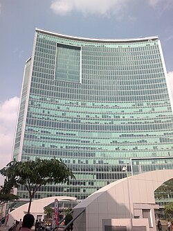
 WTC,Rajajinagar, Bengaluru | |
| Coordinates: 12°58′N 77°34′E / 12.97°N 77.57°E | |
| Country | India |
| State | Karnataka |
| Metro | Bangalore |
| Languages | |
| • Official | Kannada |
| Time zone | UTC+5:30 (IST) |
| PIN | |
| Vehicle registration | KA-02 |
Rajajinagar is a residential locality and business hub in the west of Bangalore. It's one of the zones of BBMP. It is bordered by Basaveshwaranagar, Malleshwaram, Mahalakshmipuram alias West of Chord road 2nd stage, Mahalakshmi Layout, Vijayanagar and Rajajinagar Industrial Suburb. It serves as a centre place to all in Bangalore. 70th Birthday to Rajajinagara!
Inaugurated by Maharaja's of Mysore Jayachamaraja Wadiyar, Rajajinagar Pillar on 03/07/1949. 70th birthday to Rajajinagara
Named after statesman C Rajagopalachari, a plaque in the Rajajinagar pillar indicates that 1,000 acres of land given for the locality was divided into industrial and housing areas. The former consisted of 140 acres for textiles, 220 acres for machinery, 100 acres for chemical plants and 40 acres for the food sector. About 4,000 housing plots were created in the remaining 500 acres. Rajajinagar was built at an estimated cost of Rs 50 lakh.
External links
Bengaluru's residential area Rajajinagar was initially planned as an industrial suburb
This section is empty. You can help by adding to it. (April 2014) |

