
Troy
.jpg)  Top: Walls of Late Bronze Age TroyBottom: Sanctuary from Greek / Roman Troy | |
 Shown within Marmara  Troy (Turkey)  Troy (Europe) | |
| Location | Hisarlik, Çanakkale Province, Turkey |
|---|---|
| Region | Troad |
| Coordinates | 39°57′27″N 26°14′20″E / 39.95750°N 26.23889°E |
| Type | Ancient city |
| Part of | Historical National Park of Troia |
Troy (Greek: Τροία and Latin: Troia, Hittite: 𒋫𒊒𒄿𒊭 Truwiša) or Ilion (Greek: Ίλιον and Latin: Ilium, Hittite: 𒃾𒇻𒊭 Wiluša) was an ancient city located at Hisarlik in present-day Turkey, 30 kilometres (19 mi) south-west of Çanakkale and about 6 kilometres (4 mi) miles east of the Aegean Sea. It is known as the setting for the Greek myth of the Trojan War.
In Ancient Greek literature, Troy is portrayed as a powerful kingdom of the Heroic Age, a mythic era when monsters roamed the earth and gods interacted directly with humans. The city was said to have ruled the Troad until the Trojan War led to its complete destruction at the hands of the Greeks. The story of its destruction was one of the cornerstones of Greek mythology and literature, featuring prominently in the Iliad and the Odyssey, and referenced in numerous other poems and plays. Its legacy played a large role in Greek society, with many prominent families claiming descent from those who had fought there. In the Archaic era, a new city was built at the site where legendary Troy was believed to have stood. In the Classical era, this city became a tourist destination, where visitors would leave offerings to the legendary heroes.
Until the late 19th century, scholars regarded the Trojan War as entirely legendary. However, starting in 1871, Heinrich Schliemann and Frank Calvert excavated the site of the classical era city, under whose ruins they found the remains of numerous earlier settlements. Several of these layers resemble literary depictions of Troy, leading some scholars to conclude that there is a kernel of truth to the legends. Subsequent excavations by others have added to the modern understanding of the site, though the exact relationship between myth and reality remains unclear.
The archaeological site of Troy consists of nine major layers, the earliest dating from the Early Bronze Age, the latest from the Byzantine era. Each of these layers has sublayers for a total of 46 strata. The mythic city is typically identified with one of the Late Bronze Age layers, such as Troy VI, Troy VIIa, or Troy VIIb. The archaeological site is open to the public as a tourist destination, and was added to the UNESCO World Heritage list in 1998.
Name
In Classical Greek, the city was referred to as both Troia (Τροία) and Ilion (Ἴλιον) or Ilios (Ἴλιος). Metrical evidence from the Iliad and the Odyssey suggests that the latter was originally pronounced Wilios. These names may date back to the Bronze Age, as suggested by Hittite records which reference a city in northwest Anatolia called 𒌷𒃾𒇻𒊭 Wilusa or 𒋫𒊒𒄿𒊭 Truwisa;[1][a][2][3][4] in Greek myth, these names were held to originate from the names of the kingdom's founders, Tros and his son Ilus.[5][6]
In Latin, the city was referred to as Troia or Ilium.
Legendary Troy

The main literary work set at Troy is the Iliad, an Archaic-era epic poem which tells the story of the final year of the Trojan War. The Iliad portrays Troy as the capital of a rich and powerful kingdom. In the poem, the city appears to be a major regional power capable of summoning numerous allies to defend it.[b]
The city itself is built on a steep hill, protected by enormous sloping stone walls, rectangular towers, and massive gates whose wooden doors can be bolted shut. The city's streets are broad and well-planned. At the top of the hill is the Temple of Athena as well as King Priam's palace, an enormous structure with numerous rooms around an inner courtyard.[8](pp 59–61)[9]
In the Iliad, the Achaeans set up their camp near the mouth of the Scamander river,[10] where they beached their ships. The city itself stood on a hill across the plain of Scamander, where much of the fighting takes place.
Besides the Iliad, there are references to Troy in the other major work attributed to Homer, the Odyssey, as well as in other ancient Greek literature (such as Aeschylus's Oresteia). The Homeric legend of Troy was elaborated by the Roman poet Virgil in his Aeneid. The fall of Troy with the story of the Trojan Horse and the sacrifice of Polyxena, Priam's youngest daughter, is the subject of a later Greek epic by Quintus Smyrnaeus ("Quintus of Smyrna").
The Greeks and Romans took for a fact the historicity of the Trojan War and the identity of Homeric Troy with a site in Anatolia on a peninsula called the Troad (Biga Peninsula). Alexander the Great, for example, visited the site in 334 BC and there made sacrifices at tombs associated with the Homeric heroes Achilles and Patroclus.
Archaeological layers

The archaeological site of Troy consists of the hill of Hisarlik and the fields below it to the south. The hill is a tell, composed of strata containing the remains left behind by more than three millennia of human occupation. The primary divisions among layers are designated with Roman numerals, Troy I representing the oldest layer and Troy IX representing the most recent. Sublayers are distinguished with lowercase letters (e.g. VIIa and VIIb) and further subdivisions with numbers (e.g. VIIb1 and VIIb2). An additional major layer known as Troy 0 predates the layers which were initially given Roman numeral designations.
The layers have been given relative dates by comparing artifacts found in them to those found at other sites. However, precise absolute dates are not always possible due to limitations in the accuracy of C14 dating.[12]
Layer Start
BCEEnd
BCEPeriod Troy 0 c. 3600–3500 3000 Western Anatolian LSA and EB 1 (early) Troy I 3000 2550 Western Anatolian EB 1 (late) Troy II 2500 2300 Western Anatolian EB 2 Troy III 2300 2200 Western Anatolian EB 3 (early) Troy IV 2200 2000 Western Anatolian EB 3 (middle) Troy V 2000 1750 Western Anatolian EB 3 (late) Troy VI 1750 1300 West. Anat. MBA (Troy VI, early)
West. Anat. LBA (Troy VI middle and late)Troy VIIa 1300 1180 Western Anatolian LBA Troy VIIb 1180 950 Western Anatolian LBA – Dark Age Troy VIII 950 85 Classical and Hellenistic Troy Troy IX 85 500CE Roman Troy
Troy 0
Troy 0 is a layer discovered later than others, predating what had previously been the earliest at the site. Remains of the layer, first identified in 2019, are not very substantial and its exact dating remains unclear, although Troy 0 was likely no older than c. 3600–3500 BC.[13] Traces of burns, pottery and wooden beams were found in a layer below the Troy I layer, confirming the existence of the Troy 0 layer.
Troy I
.jpg)
Troy I was a small village founded around 3000 BC. In this era, the site was adjacent to a shallow bay which gradually silted up over the subsequent millennia. The village consisted of stone and mudbrick houses which were attached to one another and surrounded by stone walls. Finds from this layer include dark colored handmade pottery and artifacts made of copper. It had cultural similarities to Aegean sites such as Poliochni and Thermi, as well as to Anatolian sites such as Bademağacı.[14]
Troy II
Troy II was built around 2550 BC. It was twice the size of the preceding city, featuring both a citadel and a lower town. The citadel contained large megaron-style buildings around a courtyard which was likely used for public events such as audiences or religious ceremonies. It was protected by massive stone walls which were topped with mudbrick superstructures. Houses in the lower town were protected by a wooden palisade. Finds from this layer include wheel-made pottery, and numerous items made from precious metals which attest to economic and cultural connections with regions as far as the Balkans and Afghanistan. Troy II was destroyed twice. After the first destruction, the citadel was rebuilt with a dense cluster of small houses. The second destruction took place around 2300 BC, as part of a crisis that affected other sites in the Eastern Mediterranean and the Middle East.[14][15]
Troy II is notable for having been misidentified as Homeric Troy, during initial excavations, because of its massive architecture, treasure hoards, and catastrophic destruction. In particular Schliemann saw Homer's description of Troy's Scaean Gate reflected in Troy II's imposing western gate. However, later excavations demonstrated that the site was a thousand years too old to have coexisted with Mycenaean Greeks.[14][15][16][17]
-
 Southwest gate of Troy II.
 -
 Side view of ramp.
 -
 Troy II walls
 -
 Troy II


,_Turkey_(7446526244).jpg)
.jpg)
Troy III–V

Troy continued to be occupied between 2300 BC and 1750 BC. However, little is known about these several layers due to Schliemann's reckless excavation practices. In order to fully excavate the citadel of Troy II, he destroyed most remains from this period without first documenting them. These settlements appear to have been smaller and poorer than previous ones, though this interpretation could be merely the result of gaps in the surviving evidence. The settlements included a dense residential neighborhood in the citadel. Walls from Troy II may have been reused as part of Troy III. By the period of Troy V, the city had once again expanded outside the citadel to the west. Troy IV sees the introduction of domed ovens. In Troy V, artifacts include Anatolian-style "red-cross bowls" as well as imported Minoan objects.[14]
Troy VI–VII
Troy VI–VII was a major Late Bronze Age city consisting of a steep fortified citadel and a sprawling lower town below it. It was a thriving coastal city with a considerable population, equal in size to second-tier Hittite settlements. It had a distinct Northwest Anatolian culture and extensive foreign contacts, including with Mycenaean Greece, and its position at the mouth of the Dardanelles has been argued to have given it the function of regional capital, its status protected by treaties.[18]
Aspects of its architecture are consistent with the Iliad's description of mythic Troy, and several of its sublayers (VIh and VIIa) show potential signs of violent destruction. Thus, these sublayers are among the candidates for a potential historical setting of those myths.[8](p 59)
Troy VI and VII were given separate labels by early excavators, but current research has shown that the first several sublayers of Troy VII were in fact continuations of the earlier city. Although some scholars have proposed revising the nomenclature to reflect this consensus, the original terms are typically used to avoid confusion.[19][20][8](p 198)
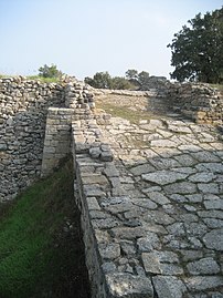
Troy VI
Troy VI existed from around 1750 BC to 1300 BC. Its citadel was divided into a series of rising terraces, of which only the outermost is reasonably well-preserved. On this terrace, archaeologists have found the remains of freestanding multistory houses where Trojan elites would have lived. These houses lacked ground-floor windows, and their stone exterior walls mirrored the architecture of the citadel fortifications. However, they otherwise display an eclectic mix of architectural styles, some following the classic megaron design, others even having irregular floorplans. Some of these houses show potential Aegean influence, one in particular resembling the megaron at Midea in the Argolid. Archaeologists believe there may have been a royal palace on the highest terrace, but most Bronze Age remains from the top of the hill were cleared away by classical era building projects.[8](pp 58–59)[20]
,_Turkey_(7446656654).jpg)
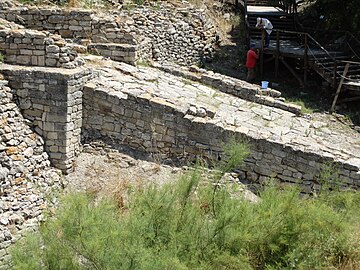
The citadel was enclosed by massive walls. Present-day visitors can see the limestone base of these walls, which are five metres (16 ft) thick and eight metres (26 ft) tall. However, during the Bronze Age they would have been overlaid with wood and mudbrick superstructures, reaching a height over nine metres (30 ft). The walls were built in a "sawtooth" style commonly found at Mycenaean citadels, divided into seven metres (23 ft)-ten metres (33 ft) segments which joined with one another at an angle. The walls also have a notable slope, similar to those at other sites including Hattusa. These walls were watched over by several rectangular watchtowers, which would also have provided a clear view of Trojan plain and the sea beyond it. The citadel was accessed by five gates, which led into paved and drained cobblestone streets. Some of these gates featured enormous pillars which serve no structural purpose and have been interpreted as religious symbols.[8](pp 58–59)[20][21]
The lower town was built to the south of the citadel, covering an area of roughly 30 hectares. Remains of a dense neighborhood have been found just outside the citadel walls, and traces of other buildings and Late Bronze Age pottery have been found further away. Little of it has been excavated, and few remains are likely to exist; buildings in the lower city are likely to have been made of wood and other perishable materials, and much of the area was built over in the classical and Roman era. The extent of the lower town is evidenced by a defensive ditch cut down to the bedrock and postholes which attest to wooden ramparts or walls which would have once been the outer defense of the city.[20][22]
The lower city was only discovered in the late 1980s, earlier excavators having assumed that Troy VI occupied only the hill of Hisarlik. Its discovery led to a dramatic reassessment of Troy VI, showing that it was over 16 times larger than had been assumed, and thus a major city with a large population rather than a mere aristocratic residence.[20][22][8](pp 61–64)
The material culture of Troy VI appears to belong to a distinct Northwest Anatolian cultural group, with influences from the Anatolia, the Aegean, and the Balkans. The primary local pottery styles were wheel-made West Anatolian Gray Ware and Tan ware, local offshoots of an earlier Middle Helladic tradition. Foreign pottery found at the site includes Minoan, Mycenaean, Cypriot, and Levantine items. Local potters also made their own imitations of foreign styles, including Gray Ware and Tan Ware pots made in Mycenaean-style shapes. Although the city appears to have been within the Hittite sphere of influence, no Hittite artifacts have been found in Troy VI. Also notably absent are sculptures and wall paintings, otherwise common features of Bronze Age cities. Troy VI is also notable for its architectural innovations as well as its cultural developments, which included the first evidence of horses at the site.[20][22] The language spoken in Troy VI is unknown. One candidate is Luwian, an Anatolian language believed to have been spoken in the general area. Potential evidence comes from a biconvex seal inscribed with the name of a person using Luwian hieroglyphs. However, available evidence is not sufficient to establish that Luwian was actually spoken by the city's population, and a number of alternatives have been proposed.[8](pp 117–122)[23][24]
Troy VI was destroyed around 1300 BC, corresponding with the sublayer known as Troy VIh. Evidence of Troy VIh's destruction includes collapsed masonry, and subsidence in the southeast of the citadel, which led its initial excavators to conclude that it was destroyed by an earthquake. However, alternative hypotheses include an internal uprising as well as a foreign attack.[20][8](pp 64–66)
-
 Troy VI East Gate
 -
 Tower at the East Gate Complex
 -
 East Gate cul de sac (Troy IX walls on the right)
 -
 Wall segment near the East Gate
 -
 Side view of wall
 -
 South Gate
 -
 Non-structural pillar at the South Gate


,_Turkey_(7446473680).jpg)

.jpg)

Troy VIIa
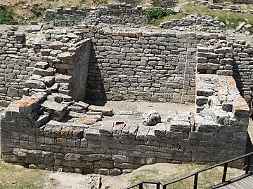
Troy VIIa was the final layer of the Late Bronze Age city. It was built soon after the destruction of Troy VI, seemingly by its previous inhabitants. The builders reused many of the earlier city's surviving structures, notably its citadel wall, which they renovated with additional stone towers and mudbrick breastworks. Numerous small houses were added inside the citadel, filling in formerly open areas. New houses were also built in the lower city, whose area appears to have been greater in Troy VIIa than in Troy VI. In many of these houses, archaeologists found enormous storage jars called pithoi buried in the ground. Troy VIIa seems to have been built by survivors of Troy VI's destruction, as evidenced by continuity in material culture. However, the character of the city appears to have changed, the citadel growing crowded and foreign imports declining.[20][8](p 59)
The city was destroyed around 1180 BC, roughly contemporary with the Late Bronze Age collapse but subsequent to the destruction of the Mycenaean palaces. The destruction layer shows evidence of enemy attack, including scorch marks.[20][14][8](p 59)
Troy VIIb
,_Turkey_(7446237818).jpg)
After the destruction of Troy VIIa around 1180 BC, the city was rebuilt as Troy VIIb. Older structures were again reused, including Troy VI's citadel walls. Its first phase, Troy VIIb1, is largely a continuation of Troy VIIa. Residents continued using wheel-made Grey Ware pottery alongside a new handmade style sometimes known as "barbarian ware". Imported Mycenaean-style pottery attests to some continuing foreign trade.[20][14][8](pp 66–67)
One of the most striking finds from Troy VIIb1 is a hieroglyphic Luwian seal giving the names of a woman and a man who worked as a scribe. The seal is important since it is the only example of preclassical writing found at the site, and provides potential evidence that Troy VIIb1 had a Luwian-speaking population. However, the find is puzzling since palace bureaucracies had largely disappeared by this era. Proposed explanations include the possibility that it belonged to an itinerant freelance scribe and alternatively that it dates from an earlier era than its find context would suggest.[20][14][8](p 118)
Troy VIIb2 is marked by cultural changes including walls made of upright stones and a handmade knobbed pottery style known as Buckelkeramik. These practices, which existed alongside older local traditions, have been argued to reflect immigrant populations arriving from southwest Europe. Pottery finds from this layer also include imported Protogeometric pottery, showing that Troy was occupied continuously well into the Iron Age, contrary to later legend.[20][14][8](pp 66–67)
Troy VIIb was destroyed by fire around 950 BC. However, some houses in the citadel were left intact and the site continued to be occupied, if only sparsely.[20][14]
Troy VIII–IX
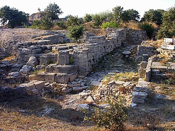
Troy VIII was founded during the Greek Dark Ages and lasted until the Roman era. Though the site had never been entirely abandoned, its redevelopment as a major city was spurred by Greek immigrants who began building around 700 BC. During the Archaic period, the city's defenses once again included the reused citadel wall of Troy VI. Later on, the walls became tourist attraction and sites of worship. Other remains of the Bronze Age city were destroyed by the Greeks' building projects, notably the peak of the citadel where the Troy VI palace is likely to have stood. By the classical era, the city had numerous temples, a theater, among other public buildings, and was once again expanding to the south of the citadel. Troy VIII was destroyed in 85 BC, and subsequently rebuilt as Troy IX. A series of earthquakes devastated the city around 500 AD, though finds from the Late Byzantine era attest to continued habitation at a small scale.[20][14]
-
 Troy VIII Temple of Athena, built over the ruins of the Bronze Age palatial complex
 -
 Troy IX Odeon
 -
 Troy IX Roman bath
,_Turkey_(7446501008).jpg)
,_Turkey.jpg)
,_Turkey_(7446699076).jpg)
Excavation history
The search for Troy

With the rise of critical history, Troy and the Trojan War were largely consigned to legend.[c] Those who departed from this general view became the first archaeologists at Troy.[d]
Early modern travellers in the 16th and 17th centuries, including Pierre Belon and Pietro Della Valle, had identified Troy with Alexandria Troas, a ruined Hellenistic town approximately 20 kilometres (12 mi) south of Hisarlik.[27] In the late 18th century, Jean Baptiste LeChevalier identified a location near the village of Pınarbaşı, Ezine, a mound approximately 5 kilometres (3.1 mi) south of the currently accepted location. Published in his Voyage de la Troade, it was the most commonly proposed location for almost a century.[28]
In 1822, the Scottish journalist Charles Maclaren was the first to identify with confidence the position of the city as it is now known.[29][30] In the second half of the 19th century archaeological excavation of the site believed to have been Homeric Troy began. The Hisarlik mound was about 200 meters long and somewhat less than 150 meters wide. It rose 31.2 meters above the plain and 38.5 meters above sea level.
Frank Calvert
The first excavation at Hisarlik, a small sounding, was conducted in 1865 by Frank Calvert, a Turkish Levantine man of English descent who owned a farm nearby. Calvert made extensive surveys of the site, identifying it with classical-era Troy.[31] This identification helped him convince Heinrich Schliemann that Troy was there, and to partner with him in its further excavation.[e][33]
Heinrich Schliemann
_b_713.jpg)
In 1868, German businessman Heinrich Schliemann visited Calvert, and secured permission to excavate Hisarlik. Schliemann believed that the literary events of the works of Homer could be verified archaeologically, and he decided to use his wealth to locate it.
As with Calvert and others, in April 1870 Schliemann began by excavating a trench across the mound of Hisarlik to the depth of the settlements, today called "Schliemann's Trench."[34] In 1871–1873 and 1878–1879, 1882 and 1890 (the later two joined by Wilhelm Dörpfeld), he discovered the ruins of a series of ancient cities dating from the Bronze Age to the Roman period.[35] Schliemann was planning for another excavation season in 1891 when he died in December 1890. He proposed that the second layer, Troy II, corresponded to the city of legend, though later research has shown that it predated the Mycenaean era by several hundred years. Some of the most notable artifacts found by Schliemann are known as Priam's Treasure, after the legendary Trojan king. Many of these ended up in the Istanbul Archaeology Museum. Almost all the precious metal objects that went to Berlin were confiscated by the Soviet Union in 1945 and are now in Pushkin Museum in Moscow. Even in his own time Schliemann's legacy was controversial because of his excavation methods which included removing features he considered insignificant without first studying and documenting them.[34]

.jpg)
Modern excavations
Wilhelm Dörpfeld
Wilhelm Dörpfeld (1893–1894) began excavating the site alongside Schliemann and later inherited management of the site and published his own independent work.[36] His chief contributions were to the study of Troy VI and VII, which Schliemann had overlooked due to his fixation on Troy II. Dörpfeld's interest in these layers was triggered by the need to close a hole in the initial excavators' chronology known as "Calvert's Thousand Year Gap".[37] During his excavation, Dörpfeld came across a section of the Troy VI wall which was weaker than the rest. Since the mythic city had likewise had a weak section of its walls, Dörpfeld became convinced that this layer corresponded to Homeric Troy.[38] Schliemann himself privately agreed that Troy VI was more likely to be the Homeric city, but he never published anything stating so.[39]
University of Cincinnati
Carl Blegen
Carl Blegen, professor at the University of Cincinnati, managed the site 1932–38. Wilhelm Dörpfeld collaborated with Blegen.[40] These archaeologists, though following Schliemann's lead, added a professional approach not available to Schliemann. He showed that there were at least nine cities. In his research, Blegen came to a conclusion that Troy's nine levels could be further divided into forty-six sublevels,[41] which he published in his main report.[42]
Korfmann
In 1988, excavations were resumed by a team from the University of Tübingen and the University of Cincinnati under the direction of Professor Manfred Korfmann, with Professor Brian Rose overseeing Post-Bronze Age (Greek, Roman, Byzantine) excavation along the coast of the Aegean Sea at the Bay of Troy. Possible evidence of a battle was found in the form of bronze arrowheads and fire-damaged human remains buried in layers dated to the early 12th century BC. The question of Troy's status in the Bronze-Age world has been the subject of a sometimes acerbic debate between Korfmann and the Tübingen historian Frank Kolb in 2001–2002.
Korfmann proposed that the location of the city indicated a commercially oriented economy that would have been at the center of a vibrant trade between the Black Sea, Aegean, Anatolian and Eastern Mediterranean regions. Kolb disputed this thesis, calling it "unfounded" in a 2004 paper. He argued that archaeological evidence shows that economic trade during the Late Bronze Age was quite limited in the Aegean region compared with later periods in antiquity. On the other hand, the Eastern Mediterranean economy was more active during this time, allowing for commercial cities to develop only in the Levant. Kolb also noted the lack of evidence for trade with the Hittite Empire.[43]
One of the major discoveries of these excavations was the Troy VI–VII lower city. This discovery led to a major reinterpretation of the site, which had previously been regarded as a small aristocratic residence rather than a major settlement.
Recent developments
In summer 2006, the excavations continued under the direction of Korfmann's colleague Ernst Pernicka, with a new digging permit.[44]
In 2013, an international team made up of cross-disciplinary experts led by William Aylward, an archaeologist at the University of Wisconsin-Madison, was to carry out new excavations. This activity was to be conducted under the auspices of Çanakkale Onsekiz Mart University and was to use the new technique of "molecular archaeology".[45] A few days before the Wisconsin team was to leave, Turkey cancelled about 100 excavation permits, including Wisconsin's.[46]
In March 2014, it was announced that a new excavation would take place to be sponsored by a private company and carried out by Çanakkale Onsekiz Mart University. This will be the first Turkish team to excavate and is planned as a 12 month excavation led by associate professor Rüstem Aslan. The University's rector stated that "Pieces unearthed in Troy will contribute to Çanakkale's culture and tourism. Maybe it will become one of Turkey's most important frequented historical places."[47]
Historical Troy
Troy I–V predate writing and thus study of them falls into the category of prehistoric archaeology. However, Troy emerges into protohistory in the Late Bronze Age, as records mentioning the city begin to appear at other sites. Troy VIII and Troy IX are dated to the historical period and thus are part of history proper.
Troy VI–VII in Hittite records
Troy VI–VII is thought to correspond to the placenames Wilusa and Taruisa known from Hittite records. These correspondences were first proposed in 1924 by E. Forrer, who also suggested that the name Ahhiyawa corresponds to the Homeric term for the Greeks, Achaeans. These proposals were primarily motivated by linguistic similarities, since "Taruisa" is a plausible match for the Greek name "Troia" and "Wilusa" likewise for the Greek "Wilios" (later "Ilios"). Subsequent research on Hittite geography has made these identifications more secure, though not all scholars regard them as firmly established.[48](pp 1–6)[8](pp 86, 181–182)
Wilusa first appears in Hittite records around 1400 BC, when it was one of the twenty-two states of the Assuwa Confederation which unsuccessfully attempted to oppose the Hittite Empire. Circumstantial evidence raises the possibility that the rebellion was supported by the Ahhiyawa.[20][8](p 59)[49][50] By the late 1300s BC, Wilusa had become politically aligned with the Hittites. Texts from this period mention two kings named Kukkunni and Alaksandu who maintained peaceful relations with the Hittites even as other states in the area did not. Wilusan soldiers may have served in the Hittite army during the Battle of Kadesh. A bit later, Wilusa seems to have experienced the political turmoil suffered by many of its neighbors. References in the Manapa-Tarhunta letter and Tawagalawa letter suggest that a Wilusan king either rebelled or was deposed. This turmoil may have been related to the exploits of Piyamaradu, a Western Anatolian warlord who toppled other pro-Hittite rulers while acting on behalf the Ahhiyawa. However, Piyamaradu is never explicitly identified as the culprit and certain features of the text suggest that he was not.[8](pp 107–111, 182–185)[48](pp 133–134, 174–177) The final reference to Wilusa in the historical record appears in the Milawata letter, in which the Hittite king Tudhaliya IV expresses his intention to reinstall a deposed Wilusan king named Walmu.[8](pp 112, 183)[48](pp 278–279, 123, 131–133)
In popular writing, these anecdotes have been interpreted as evidence for a historical kernel in myths of the Trojan War. However, scholars have not found historical evidence for any particular event from the legends, and the Hittite documents do not suggest that Wilusa-Troy was ever attacked by Greeks-Ahhiyawa themselves. Noted Hittiteologist T. Bryce cautions that our current understanding of Wilusa's history does not provide evidence for there having been an actual Trojan War since "the less material one has, the more easily it can be manipulated to fit whatever conclusion one wishes to come up with".[8](pp 183–184, 186)
Classical and Hellenistic Troy (Troy VIII)
In 480 BC, the Persian king Xerxes sacrificed 1,000 cattle at the sanctuary of Athena Ilias while marching through the Hellespontine region towards Greece.[51] Following the Persian defeat in 480–479, Ilion and its territory became part of the continental possessions of Mytilene and remained under Mytilenaean control until the unsuccessful Mytilenean revolt in 428–427. Athens liberated the so-called Actaean cities including Ilion and enrolled these communities in the Delian League. Athenian influence in the Hellespont waned following the oligarchic coup of 411, and in that year the Spartan general Mindaros emulated Xerxes by likewise sacrificing to Athena Ilias. From c. 410–399, Ilion was within the sphere of influence of the local dynasts at Lampsacus (Zenis, his wife Mania, and the usurper Meidias) who administered the region on behalf of the Persian satrap Pharnabazus.
In 399, the Spartan general Dercylidas expelled the Greek garrison at Ilion who were controlling the city on behalf of the Lampsacene dynasts during a campaign which rolled back Persian influence throughout the Troad. Ilion remained outside the control of the Persian satrapal administration at Dascylium until the Peace of Antalcidas in 387–386. In this period of renewed Persian control c. 387–367, a statue of Ariobarzanes, the satrap of Hellespontine Phrygia, was erected in front of the temple of Athena Ilias.[52] In 360–359 the city was briefly controlled by Charidemus of Oreus, a Euboean mercenary leader who occasionally worked for the Athenians.[53] In 359, he was expelled by the Athenian Menelaos son of Arrabaios, whom the Ilians honoured with a grant of proxeny—this is recorded in the earliest civic decree to survive from Ilion.[54] In May 334 Alexander the Great crossed the Hellespont and came to the city, where he visited the temple of Athena Ilias, made sacrifices at the tombs of the Homeric heroes, and made the city free and exempt from taxes.[55] According to the so-called 'Last Plans' of Alexander which became known after his death in June 323, he had planned to rebuild the temple of Athena Ilias on a scale that would have surpassed every other temple in the known world.[56]
Antigonus Monophthalmus took control of the Troad in 311 and created the new city of Antigoneia Troas which was a synoikism of the cities of Skepsis, Kebren, Neandreia, Hamaxitos, Larisa, and Kolonai. In c. 311–306 the koinon of Athena Ilias was founded from the remaining cities in the Troad and along the Asian coast of the Dardanelles and soon after succeeded in securing a guarantee from Antigonus that he would respect their autonomy and freedom (he had not respected the autonomy of the cities which were synoikized to create Antigoneia).[57] The koinon continued to function until at least the 1st century AD and primarily consisted of cities from the Troad, although for a time in the second half of the 3rd century it also included Myrlea and Chalcedon from the eastern Propontis.[58] The governing body of the koinon was the synedrion on which each city was represented by two delegates. The day-to-day running of the synedrion, especially in relation to its finances, was left to a college of five agonothetai, on which no city ever had more than one representative. This system of equal (rather than proportional) representation ensured that no one city could politically dominate the koinon.[59] The primary purpose of the koinon was to organize the annual Panathenaia festival which was held at the sanctuary of Athena Ilias. The festival brought huge numbers of pilgrims to Ilion for the duration of the festival as well as creating an enormous market (the panegyris) which attracted traders from across the region.[60] In addition, the koinon financed new building projects at Ilion, for example a new theatre c. 306 and the expansion of the sanctuary and temple of Athena Ilias in the 3rd century, in order to make the city a suitable venue for such a large festival.[61]
In the period 302–281, Ilion and the Troad were part of the kingdom of Lysimachus, who during this time helped Ilion synoikize several nearby communities, thus expanding the city's population and territory.[f] Lysimachus was defeated at the Battle of Corupedium in February 281 by Seleucus I Nikator, thus handing the Seleucid kingdom control of Asia Minor, and in August or September 281 when Seleucus passed through the Troad on his way to Lysimachia in the nearby Thracian Chersonese Ilion passed a decree in honour of him, indicating the city's new loyalties.[66] In September Seleucus was assassinated at Lysimachia by Ptolemy Keraunos, making his successor, Antiochus I Soter, the new king. In 280 or soon after Ilion passed a long decree lavishly honouring Antiochus in order to cement their relationship with him.[g] During this period Ilion still lacked proper city walls except for the crumbling Troy VI fortifications around the citadel, and in 278 during the Gallic invasion the city was easily sacked.[68] Ilion enjoyed a close relationship with Antiochus for the rest of his reign: for example, in 274 Antiochus granted land to his friend Aristodikides of Assos which for tax purposes was to be attached to the territory of Ilion, and c. 275–269 Ilion passed a decree in honour of Metrodoros of Amphipolis who had successfully treated the king for a wound he received in battle.[69]
Roman Troy (Troy IX)
A new city called Ilium (from Greek Ilion) was founded on the site in the reign of the Roman emperor Augustus. It flourished until the establishment of Constantinople, which became a bishopric in the Roman province Hellespontus (civil Diocese of Asia), but declined gradually in the Byzantine era.
The city was destroyed by Sulla's rival, the Roman general Fimbria, in 85 BC following an eleven-day siege.[70] Later that year when Sulla had defeated Fimbria, he bestowed benefactions on Ilion for its loyalty which helped rebuilding the city. Ilion reciprocated this act of generosity by instituting a new civic calendar which took 85 BC as its first year.[71] However, the city remained in financial distress for several decades despite its favoured status with Rome. In the 80s BC, Roman publicani illegally levied taxes on the sacred estates of Athena Ilias, and the city was required to call on L. Julius Caesar for restitution; while in 80 BC, the city suffered an attack by pirates.[72] In 77 BC the costs of running the annual festival of the koinon of Athena Ilias became too pressing for both Ilion and the other members of the koinon and L. Julius Caesar was once again required to arbitrate, this time reforming the festival so that it would be less of a financial burden.[73] In 74 BC the Ilians once again demonstrated their loyalty to Rome by siding with the Roman general Lucullus against Mithridates VI.[74] Following the final defeat of Mithridates in 63–62, Pompey rewarded the city's loyalty by becoming the benefactor of Ilion and patron of Athena Ilias.[75]
In 48 BC, Gaius Julius Caesar likewise bestowed benefactions on the city, recalling the city's loyalty during the Mithridatic Wars, the city's connection with his cousin Lucius, and the family's claim that they were ultimately descended from Venus through the Trojan prince Aeneas and therefore shared kinship with the Ilians.[76] In 20 BC, the emperor Augustus (Gaius Octavian Julius Caesar Augustus) visited Ilion and stayed in the house of a leading citizen, Melanippides son of Euthydikos.[77] As a result of his visit, he also financed the restoration and rebuilding of the sanctuary of Athena Ilias, the bouleuterion (council house) and the theatre. Soon after work on the theatre was completed in 12–11 BC, Melanippides dedicated a statue of Augustus in the theatre to record this benefaction.[78]
Christian bishopric
From the 4th century AD until the Byzantine era, perhaps as late as the 10th century, Ilion was the seat of a Christian bishop.
Site conservation
Troy Historical National Park

The Turkish government created the Historical National Park at Troy on September 30, 1996. It contains 136 square kilometres (53 sq mi) to include Troy and its vicinity, centered on Troy.[79] The purpose of the park is to protect the historical sites and monuments within it, as well as the environment of the region. In 1998 the park was accepted as a UNESCO World Heritage Site.
In 2015 a Term Development Revision Plan was applied to the park. Its intent was to develop the park into a major tourist site.[80] Plans included marketing research to determine the features most of interest to the public, the training of park personnel in tourism management, and the construction of campsites and facilities for those making day trips. These latter were concentrated in the village of Tevfikiye, which shares Troy Ridge with Troy.
_(8709942456).jpg)
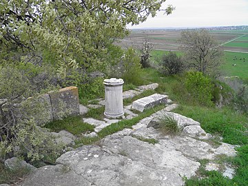
Public access to the ancient site is along the road from the vicinity of the museum in Tevfikiye to the east side of Hisarlik. Some parking is available. Typically visitors come by bus, which disembarks its passengers into a large plaza ornamented with flowers and trees and some objects from the excavation. In its square is a large wooden horse monument, with a ladder and internal chambers for use of the public. Bordering the square is the gate to the site. The public passes through turnstiles. Admission is usually not free. Within the site, the visitors tour the features on dirt roads or for access to more precipitous features on railed boardwalks. There are many overlooks with multilingual boards explaining the feature. Most are outdoors, but a permanent canopy covers the site of an early megaron and wall.
UNESCO World Heritage Site
The archaeological site of Troy was added to the UNESCO World Heritage list in 1998 in recognition of its historical, cultural, and scientific significance.[81]
Troy Museum


In 2018 the Troy Museum (Turkish Troya Müzesi) was opened at Tevfikiye village 800 metres (870 yd) east of the excavation. A design contest for the architecture had been won by Yalin Mimarlik in 2011. The cube-shaped building with extensive underground galleries holds more than 40,000 portable artifacts, 2000 of which are on display. Artifacts were moved here from a few other former museums in the region. The range is the entire prehistoric Troad. Displays are multi-lingual. In many cases the original contexts are reproduced.
See also
Footnotes
- ^ "Troy or Ilios (or Wilios) is most probably identical with Wilusa or Truwisa ... mentioned in the Hittite sources[1]
- ^
"And Troy prevails by armies not her own".[7](line 160)
"Assemble all the united bands of Troy; / In just array let every leader call / The foreign troops: this day demands them all."[7](lines 974–976) - ^
George Grote in particular affirmed that it was
- "... in the eyes of modern inquiry essentially a legend and nothing more. ... If we are asked whether it be not a legend embodying portions of historical matter ... our answer must be, that as the possibility of it cannot be denied, so neither can the reality of it be affirmed."[25]
- ^ "Calvert had introduced Schliemann to the theory that Troy lay at Hisarlik."[26]
- ^ "... by his generosity and constant assistance to Schliemann, enabled him to transform himself with such spectacular success from a businessman into an archaeologist."[32]
- ^ In a description of the region, Strabo reports that
- "[Lysimachus] adds to this circle the cities of antiquity already destroyed".
- [Λυσίμαχος] συνῴκισέ τε εἰς αὐτὴν τὰς κύκλῳ πόλεις ἀρχαίας ἤδη κεκακωμένας.[62]
Birytis and Gentinos are not securely located, but recent excavations at Sigeion appear to independently confirm Strabo's account by indicating an abandonment date soon after c. 300.[64] This may have been punishment for Sigeion resisting Lysimachus in 302.[65] - "[Lysimachus] adds to this circle the cities of antiquity already destroyed".
- ^ A minority of scholars instead attempt to date this inscription to the reign of Antiochus III (222–187 BC).[67]
References
- ^ a b Korfmann, Manfred O. (2007). Winkler, Martin M (ed.). Troy: From Homer's Iliad to Hollywood epic. Oxford, England: Blackwell Publishing Limited. p. 25. ISBN 978-1-4051-3183-4.
- ^ Burney, Charles (2004). "Wilusa". Historical dictionary of the Hittites. Metuchen, N.J: Scarecrow Press. p. 311. ISBN 978-0-8108-4936-5.
- ^ Beekes, R.S.P. (2009). Etymological Dictionary of Greek. Brill. p. 588.
- ^ Said, Suzanne; Webb, Ruth (2011). Homer and the Odyssey. Oxford University Press. p. 77.
- ^ Diodorus Siculus. Bibliotheca historica. 4.75.3.
- ^ Virgil. Aeneid. 6.637-678.
- ^ a b "Book II". Iliad. Translated by Pope, A.
- ^ a b c d e f g h i j k l m n o p q r Bryce, T. (2005). The Trojans and their Neighbours. Taylor & Francis. ISBN 978-0-415-34959-8.
- ^ Smith, William, ed. (2020) [1854]. "Ilium". Dictionary of Greek and Roman Geography. Perseus Digital Library.
- ^ Cenker, Işil Cerem; Thys-Şenocak, Lucienne (2008). Shopes, Linda; Hamilton, Paula (eds.). Oral History and Public Memories. Philadelphia, PA: Temple University Press. p. 76. ISBN 978-1-59213-141-9.
- ^ This "Archeological plan of the Hisarlik citadel" was created by user Bibi Saint-Pol and contributed to Commons in 2007.
- ^ Yakar, Jak (1979). "Troy and Anatolia early Bronze Age chronology". Anatolian Studies. 29: 52. doi:10.2307/3642730. JSTOR 3642730. S2CID 162340023.
- ^ "Ancient city of Troy likely founded 600 years earlier than thought". Daily Sabah History. Istanbul. 9 January 2019.
- ^ a b c d e f g h i j Jablonka, Peter (2012). "Troy". In Cline, Eric (ed.). The Oxford Handbook of the Bronze Age Aegean. Oxford University Press. pp. 849–861. doi:10.1093/oxfordhb/9780199873609.013.0063. ISBN 978-0199873609.
- ^ a b Neer, Richard T. (2012). Greek Art and Archaeology. New York, NY: Thames & Hudson. p. 21. ISBN 9780500288771.
- ^ Schliemann 1881, pp. 75, 277
- ^ Schliemann, Heinrich (1968). Troy and its Remains. Benjamin Blom.
- ^ Latacz 2004, p. 48
- ^ Korfmann 2013, p. 60
- ^ a b c d e f g h i j k l m n o Jablonka, Peter (2011). "Troy in regional and international context". In Steadman, Sharon; McMahon, Gregory (eds.). The Oxford Handbook of Ancient Anatolia. Oxford University Press. doi:10.1093/oxfordhb/9780195376142.013.0032.
- ^ Knight, W.F.J. (1934). "The pillars at the south gate of Troy VI". The Journal of Hellenic Studies. 54 (2): 210. doi:10.2307/626868. ISSN 0075-4269. JSTOR 626868. S2CID 162416526.
- ^ a b c Korfmann 2003, pp. 29–30
- ^ Watkins, C. (1986) [October 1984]. "The language of the Trojans". In Mellink, Machteld J. (ed.). Troy and the Trojan War. Troy and the Trojan War: A symposium held at Bryn Mawr College. Bryn Mawr Commentaries. Bryn Mawr, PA: Bryn Mawr College.
- ^ Yakubovich, Ilya (2008). Sociolinguistics of the Luvian language (PDF) (PhD thesis). University of Chicago. section 3.6.
- ^ Grote, George (1869). A History of Greece from the Earliest Period to the Close of the Generation Contemporary with Alexander the Great. Vol. 1. London, UK: J. Murray. p. 312.
- ^ Allen 1995, p. 4
- ^ Schliemann 1881, p. 184.
- ^ Schliemann 1881, pp. 184–191.
- ^ MacLaren, Charles (1822). A Dissertation On the Topography of the Plain of Troy. Bibliobazaar. ISBN 978-1-146-73161-4. Retrieved 28 December 2014.
Including an examination of the opinions of Demetrius, Chevalier, Dr. Clarke, and Major Rennell.
- ^ Schliemann 1881, p. 189.
- ^ Wood 1985, pp. 42–44
- ^ Robinson 1994, p. 153
- ^ Allen 1995, p. 380
- ^ a b [1]C. Schuchhardt, "Schliemans Excavations: An archaeological and historical study", MacMillan and Co, London, 1891
- ^ Luce, J.. "FOUR. TROY, HOMER, AND THE ARCHAEOLOGISTS". Celebrating Homer's Landscapes: Troy and Ithaca Revisited, New Haven: Yale University Press, 2022, pp. 81–110
- ^ Dörpfeld, Wilhelm (1902). Troja und Ilion. Beck & Barth.
- ^ Allen 1995, p. 142.
- ^ Wood 1985, p. 89
- ^ Allen 1995, p. 143
- ^ Blegen, Carl W. “Excavations at Troy 1932.” American Journal of Archaeology, vol. 36, no. 4, 1932, pp. 431–51
- ^ Allen 1995, p. 259
- ^ Blegen, Carl W. (1950). Troy: Excavations conducted by the University of Cincinnati, 1932–1938 (PDF). Princeton University Press.
- ^ Kolb, F. (2004). "Troy VI: A trading center and commercial city?". Forum Article. American Journal of Archaeology. 8 (4): 577–613. doi:10.3764/aja.108.4.577. JSTOR 40025731. S2CID 163779042.
- ^ "Project Troia". University of Tübingen / University of Cincinnati. Archived from the original on 26 May 2014. Retrieved 6 March 2014.
- ^ Devitt, Terry (15 October 2012). "UW-Madison archaeologists to mount new expedition to Troy". news.wisc.edu (Press release). Madison, WI: University of Wisconsin.
- ^ Simmons, Dan (22 July 2013). "UW-Madison archaeology trip to Troy postponed until next summer". Wisconsin State Journal. Retrieved 6 May 2014.
- ^ Çanakkale (13 March 2014). "New term excavations start at city of Troy with Turkish team". Hurriyet daily News. Dogan News Agency. Retrieved 28 December 2014.
- ^ a b c Beckman, Gary; Bryce, Trevor; Cline, Eric (2012). The Ahhiyawa Texts. Brill. ISBN 978-1589832688.
- ^ Cline, Eric (2014). 1177 BC: The Year Civilization Collapsed. Princeton University Press. pp. 33–35. ISBN 978-0691168388.
- ^ Beckman, Gary; Bryce, Trevor; Cline, Eric (2012). "Epilogue: Mycenaean-Hittite Interconnections in the Late Bronze Age Revisited". The Ahhiyawa Texts. Brill. ISBN 978-1589832688.
- ^ Herodotus. Histories. 7.43.
- ^ Diodorus Siculus. Bibliotheca historica. 17.17.6.
- ^ Demosthenes. [no title cited]. 23.154–157;
Aeneas Tacticus. Περὶ τοῦ πῶς χρὴ πολιορκουμένους ἀντέχειν [How to Survive a Siege] (in Greek). 24.3–14. - ^ Inschriften von Ilion 23.
- ^ Arrian. Anabasis. 1.11–12.
Diodorus Siculus. Bibliotheca historica. 17.17–18.
Plutarch. Life of Alexander. 15.
Marcus Junianus Justinus Frontinus. Historia Philippicae (et Totius Mundi). 9.5.12.
Strabo. Geographica. 13.1.26, 32. - ^ Diodorus Siculus. Bibliotheca historica. 18.4.5.
- ^ Inschriften von Ilion 1.
- ^ Regarding Myrlea and Calchedon: Inschriften von Ilion 5–6.
- ^ Knoepfler, D. (2010). "Les agonothètes de la Confédération d'Athéna Ilias: une interpretation nouvelle des données épigraphiques et ses conséquences pour la chronologie des émissions monétaires du Koinon". Studi Ellenistici (in French). 24: 33–62.
- ^ Robert, L. (1966). Panegyris. Monnaies antiques en Troade. Paris, FR. pp. 18–46.
{{cite book}}: CS1 maint: location missing publisher (link) - ^ Re. theatre:
- Inschriften von Ilion 1.
- Rose, C.B. (2003). "The temple of Athena at Ilion". Studia Troica. 13: 27–88.
- Hertel, D. (2004). "Zum Heiligtum der Athena Ilias von Troia IX und zur frühhellenistischen Stadtanlage von Ilion". Arch.Anz. (in German): 177–205.
- ^ Strabo. Geographica. 13.1.26.
- ^ Cook, J.M. (1973). The Troad. Oxford. p. 364.
- ^ Schäfer, Th. (2009). Kazı Sonuçları Toplantısı. 32.2: 410–412;
Schäfer, Th. (2012). Kazı Sonuçları Toplantısı. 33.2: 248–249. - ^ Diodorus Siculus. Bibliotheca historica. 20.107.4.
- ^ Inschriften von Ilion 31.
- ^ Inschriften von Ilion 32.
- ^ Strabo. Geographica. 13.1.27.
- ^ Inschriften von Ilion 33 (Aristodikides), 34 (Metrodoros).
- ^ Strabo. Geographica. 13.1.27.
Livy. Periochae. 83. - ^ Inschriften von Ilion 10.2–3.
- ^ Inchriften von Ilion 71 (publicani), 73 (pirates).
- ^ Inschriften von Ilion 10.
- ^ Plutarch. Lucullus. 10.3, 12.2.
- ^ Supplementum Epigraphicum Graecum 46.1565.
- ^ Lucan. Pharsalia. 9.964–999.
Suetonius. Divus Julius. 79.3. - ^ Dio Cassius. Ῥωμαϊκὴ Ἱστορία [Roman History] (in Greek). 54.7.
Inschriften von Ilion 83. - ^ Inschriften von Ilion 83.
- ^ "The Historical National Park of Troy". Ministry of Culture and Tourism. 3 August 2019. Retrieved 1 February 2020.
- ^ "Troy National Park to be renovated". Daily Sabah. 30 October 2015.
- ^ "Archaeological Site of Troy". UNESCO World Heritage Centre. Retrieved 13 December 2019.
Sources
- Allen, Susan Heuck (July 1995). ""Finding the walls of Troy": Frank Calvert, excavator". American Journal of Archaeology. 99 (3): 379–407. doi:10.2307/506941. JSTOR 506941. S2CID 191391207.
- Allen, Susan Heuck (1999). "Finding the walls of Troy": Frank Calvert and Heinrich Schliemann at Hisarlik. Berkeley, CA: University of California Press. ISBN 978-0-520-20868-1.
- Bauer, Susan Wise (2007). "The battle for Troy". The History of the Ancient World: From the Earliest Accounts to the Fall of Rome. Norton. pp. 253–58. ISBN 9780393070897.
- Blegen, C.W. (1995) [1963]. Troy and the Trojans. New York, NY: Barnes & Noble Books.
- Carter, Jane Burr; Morris, Sarah P., eds. (1995). The Ages of Homer. Austin: University of Texas Press. ISBN 978-0-292-71208-9.
- Efkleidou, Kalliope (2004). Slavery and Dependent Personnel in the Linear B Archives of Mainland Greece (M.A. thesis). Cincinnati, OH: University of Cincinnati.
- Kayan, İlhan (2003). "Chapter 25 – Geoarchaeological interpretations of the 'Troian Bay'". In Wagner, Günther A.; Pernicka, Ernst; Uerpmann, Hans-Peter (eds.). Troia and the Troad – Scientific Approaches. Natural Science in Archaeology. Berlin, DE: Springer. ISBN 9783642078323.
- Korfmann, Manfred (2003). Troia in Light of New Research (PDF). Reden an der Universität Trier, Dies academicus (English ed.). Tübingen: Institute for Pre- and Protohistory and Archaeology of the Middle Ages, Tübingen University.
- Korfmann, Manfred (2013). Troia/Wilusa Guidebook. Çanakkale-Tübingen Troia Vakh (Foundation) Publication Series 1 (Enlarged and revised ed.). Istanbul: Biltur Basim Yayin ve Hizmet A.
- Latacz, Joachim (2004). Troy and Homer: Towards a Solution of an Old Mystery. Oxford: Oxford University Press. ISBN 978-0-19-926308-0.
- Robinson, Marcelle (1994). "Pioneer, scholar, and victim: An appreciation of Frank Calvert (1828-1908)". Anatolian Studies. 44: 153–168. doi:10.2307/3642989. JSTOR 3642989. S2CID 162321475.
- Schliemann, Heinrich (1881). Ilios: The city and country of the Trojans. New York, NY: Harper & Brothers.
- Watkins, Calvert (1986) [October 1984]. "The language of the Trojans". In Mellink, Machteld J. (ed.). Troy and the Trojan War. Troy and the Trojan War: A symposium held at Bryn Mawr College. Bryn Mawr, PA: Bryn Mawr College.
- Wood, Michael (1985). In Search of the Trojan War (1st ed.). BBC Books. ISBN 978-0563201618.
Additional sources
General
- Troia Projekt and CERHAS (2013). "Welcome to Troy". Troy. University of Cincinnati. Archived from the original on 14 May 2008. Retrieved 8 August 2013.
- Easton, D.F.; Hawkins, J.D.; Sherratt, A.G.; Sherratt, E.S. (2002). "Troy in Recent Perspective". Anatolian Studies. 52: 75–109. doi:10.2307/3643078. JSTOR 3643078.
Archaeological
- [2]Schliemann, Heinrich. Ilios: The City and Country of the Trojans: the Results of Researches and Discoveries on the Site of Troy and Throughout the Troad in the Years 1871-72-73-78-79: Including an Autobiography of the Author. J. Murray, 1880
- Institut für Ur; Frühgeschichte und Archäologie des Mittelalters, Universität Tübingen; Department of Classics, University of Cincinnati (2010). "Troia and the Troad – Archaeology of a Region: The new excavations at Troy". Project Troia. Institut für Ur - u. Frühgeschichte. Archived from the original on 19 May 2005. Retrieved 8 August 2013.
- Troia Project (2004). "Reconstructions". Troia VR. University of Tübingen. Archived from the original on 30 August 2013. Retrieved 8 August 2013.
- Heath, Sebastian; Tekkök, Billur, eds. (2007–2009). "Greek, Roman, and Byzantine pottery at Ilion (Troia)". Classics Department. University of Cincinnati. Retrieved 10 August 2013.
- Heath, Sebastian; Mannsperger, Dietrich; Rose, C. Brian; Wallrodt, John (2013). "Coins from Ilion (Troia)". Classics Department. University of Cincinnati. Retrieved 10 August 2013.
- Rutter, Jeremy B. (2013). "Welcome". Aegean Prehistoric Archaeology. Dartmouth College. Retrieved 10 August 2013.
Geographical
- Thomas, Neil (2003). "Geology corresponds with Homer's description of ancient Troy" (Press release). University of Delaware. Retrieved 10 August 2013 – via UDaily Archive.
Concerning ecclesiastical history
- Pius Bonifacius Gams (1931). Series episcoporum Ecclesiae Catholicae (in Latin). Leipzig. p. 445.
{{cite book}}: CS1 maint: location missing publisher (link) - Lequien, Michel (1740). Oriens christianus in quatuor Patriarchatus digestus (in Latin). Vol. I. Paris, FR. coll. 775–778.
Concerning legend
- Shepard, Alan; Powell, Stephen D., eds. (2004). Fantasies of Troy: Classical tales and the social imaginary in Medieval and early modern Europe. Toronto, Canada: Centre for Reformation and Renaissance Studies.
External links
 Definitions from Wiktionary
 Media from Commons
 Texts from Wikisource
 Travel information from Wikivoyage
 Data from Wikidata
- "Uncovering Troy". Archaeological Institute of America. Retrieved 24 January 2020.
- Miszczak, Izabela (23 March 2016). "Troy". Turkish Archaeological News.
- Miszczak, Izabela (13 December 2019). "Troy Museum". Turkish Archaeological News.
- "Hellenistic inscriptions of Ilion, in English translation". attalus.org. Retrieved 3 September 2022.
- The Many Myths of the Man Who ‘Discovered’—and Nearly Destroyed—Troy - Smithsonian Magazine - Meilan Solly - May 17, 2022

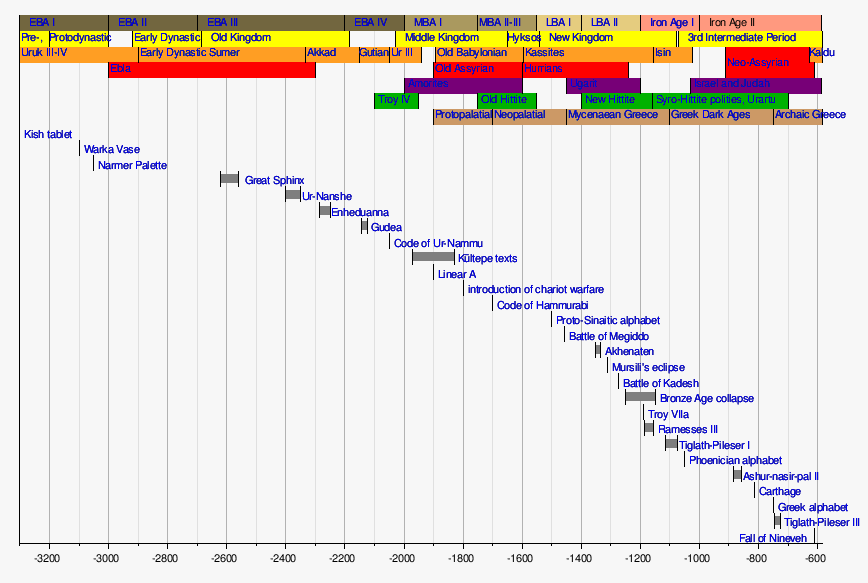
Timeline of the Ancient Near East | |
|---|---|
 | |
| Aegean | |
|---|---|
| Black Sea | |
| Central Anatolia | |
| East Anatolia | |
| Marmara | |
| Mediterranean | |
| Southeastern Anatolia | |
| Multiple regions | |
| Bronze Age | |
|---|---|
| Iron Age | |
| Classical Age | |
| International | |
|---|---|
| National | |
| Geographic | |
| Other | |
- World Heritage Sites in Turkey
- Troy
- Ancient Greek geography
- Ancient Greek archaeological sites in Turkey
- Archaeological sites in the Marmara Region
- Destroyed cities
- Former populated places in Turkey
- Geography of Çanakkale Province
- History of Çanakkale Province
- Locations in Greek mythology
- National parks of Turkey
- Populated places established in the 3rd millennium BC
- Tourist attractions in Çanakkale Province
- 30th-century BC establishments
- Ezine District
- Razed cities
- Late Bronze Age collapse
- Former kingdoms