
Seoul
Template:Infobox Korean settlement Seoul [sʌ.ul] is the capital of South Korea. As a Special City, it is administered directly by the national government. With over ten million people, Seoul is South Korea's largest city and one of the most populous cities in the world.
The city is located on the basin of the Han River in the country's northwest. The North Korean border is about 50 km to the north.
Seoul first appears in history in 18 BCE, when the Baekje kingdom established its capital Wiryeseong in what is now around Songpa-gu, southeastern Seoul. Modern Seoul descends from the Goryeo-era city called Namgyeong, which then became the capital of Korea during the Joseon dynasty.
The Seoul National Capital Area - which includes the major port city of Incheon and many satellite towns in Gyeonggi-do - has almost 23 million inhabitants, making it the second most populous metropolitan area in the world. Almost half of South Korea's population lives in the Seoul National Capital Area, and nearly one quarter in Seoul itself, making it the country's political, cultural, and economic centre.
In recent years, the metropolitan government has undertaken major environmental projects, including the restoration of Cheonggyecheon.
Name
The city has been known in the past by the successive names Wirye-seong (위례성; 慰禮城, Baekje era), Namgyeong (남경; 南京, Goryeo era), Hanseong (한성; 漢城, Joseon era) or Hanyang (한양; 漢陽). Its current name, Seoul derives from the ancient Korean word Seorabeol (서라벌; 徐羅伐) or Seobeol (서벌; 徐伐), meaning "capital city", which originally referred to Gyeongju, the capital of Silla, then called Geumseong (금성; 金星).
Unlike most place names in Korea, "Seoul" has no corresponding hanja (Chinese characters used in the Korean language). The Chinese name for Seoul is 首爾 ("Shǒu'ěr" in Chinese pronunciation).
History


The history of Seoul can be traced back as far as 18 BC, when it was established as a settlement in Baekje. It's believed that the Wiryeseong site is in the boundaries of modern day Seoul. It has thereafter been the capital of the Joseon Dynasty. In the Japanese colonization period in the early 20th century, many historical and traditional parts of Seoul were changed. The city was almost entirely destroyed in the Korean War, but an aggressive economic policy in the 1960s and 1970s helped to rebuild the city very rapidly. In the 1990s, some important historical buildings were restored, including Gyeongbokgung, one of the royal palace of the Joseon dynasty.
Geography
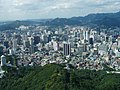
Seoul is in northwest South Korea. Seoul proper comprises 605.39 km² of area, roughly bisected into northern and southern halves by the Han River. The Han River and its surrounding area played an important role in Korean history. The Three Kingdoms of Korea strove to take control of this land, where the river was used as a trade route to China (via the Yellow Sea). However, the river is no longer actively used for navigation, because its estuary is located at the borders of the two Koreas, barred for entrance by any civilian. The city is bordered by eight mountains, as well as the more level lands of the Han River plain and western areas.
Climate
In common with the rest of South Korea, Seoul has a monsoon-influenced humid continental climate (Koppen Dwa), despite the fact that South Korea is surrounded on three sides by water.[1] Summers are generally hot and humid, with monsoons taking place from June until September. August, the hottest month, has an average temperature of 72 °F to 86 °F (22°C to 30°C) with higher temperatures possible. Winters are often very cold when compared to places of a similar latitude, with an average January temperature of 19 °F to 33 °F (-7°C to 1°C). Winters are generally much drier than summers, although on average there are 28 days of snow in Seoul each year.
Cityscape
The traditional heart of Seoul is the old Joseon Dynasty city, which is now the downtown area, where most palaces, government offices, corporate headquarters, hotels, and traditional markets are located. This area occupies the valley of Cheonggyecheon, a stream that runs from west to east through the valley before emptying into the Han River. For many years, the stream had been covered by concrete, but was recently restored through an urban revival project. To the north of downtown is Bukhan Mountain, and to the south is the smaller Namsan.
Further south are the old suburbs of Yongsan-gu and Mapo-gu, and the Han River. Across the Han River are the newer and wealthier areas of Gangnam-gu,Seocho-gu and surrounding neighborhoods. The World Trade Center of Korea is located in Gangnam-gu and this is where many expositions and conferences are held. Also in Gangnam-gu is the COEX Mall, a large indoor shopping and entertainment complex. Bamseom is an island in the middle of the Han River near Yeouido, downstream from Gangnam-gu, and is home to the National Assembly, major broadcasting studios, and a number of large office buildings, as well as the Korea Finance Building and the world's largest Pentecostal church. The Olympic Stadium, Olympic Park, and Lotte World are located in Songpa-gu, on the south side of the Han River, upstream from Gangnam-gu. South of the sprawling Gangnam area are Namhan Mountain,Cheonggye Mountain and Gwanak Mountain.

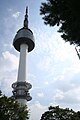
Major modern landmarks include the Korea Finance Building, N Seoul Tower, the World Trade Center, the 63 Building and the six-skyscraper residence Tower Palace. These and various high-rise office buildings, like the Seoul Star Tower and Jongno Tower, dominate the city's skyline. Due to its high density, Seoul has been equipped with a grand appearance of skyscrapers and the city council is now planning on building a series of high-rises, including 580-metre business center in Sangam Digital Media City district and an 800-metre Lotte World 2 Tower in the Jamsil (pronounced "Jam-shil") district of Songpa-gu and Gangdong-gu.
Urban and civil planning was a key concept when Seoul was first designed to serve as a capital in the late 14th century. The Royal Palaces of the Joseon Dynasty still remain in Seoul, with the main palace, Gyeongbokgung currently being restored to its original form. Today, there are eight major subway lines stretching for more than 250 kilometers, with a ninth and tenth line being planned, and also some other miscellaneous lines.
The most historically significant street in Seoul is Jongno, meaning "Bell Street," on which one can find Bosingak, a pavillion containing a large bell. The bell signaled the different times of the day and therefore controlled the four major gates to the city. The only time it is normally rung nowadays is at midnight on New Year's Eve, when it is rung thirty-three times. It was, however, rung on the day that President Kim Dae-jung took office.
Seoul's most important streetcar line ran along Jongno until it was replaced by Line 1 of the subway system in the early 1970s. Other notable streets in downtown Seoul include Euljiro (을지로; 乙支路), Teheranno (테헤란路, Tehran Street), Sejongno (세종로; 世宗路), Chungmuro (충무로; 忠武路), Yulgongno (율곡로; 栗谷路), and Toegyero (퇴계로; 退溪路).
Administrative divisions

Seoul is divided into 25 gu (구; 區) (district), which are sub-divided into 522 dong (동; 洞), which are sub-divided into 13,787 tong (통; 統), which are further divided into 102,796 ban in total.
Demographics
Nearly all of Seoul's residents are Korean, with some small Chinese and Japanese minorities. A rapidly growing population of international residents now represent about 2% of the total population [2]. Seoul’s population surpassed 10,421,000 as of the end of 2007 and the number of foreigners was 229,000, constituting 2.2 percent of the population. [1]
The crime rate in Seoul is very low. Two major religions in Seoul are Buddhism and Christianity. Other religions include Shamanism and Confucianism, the latter seen more as a pervasive social philosophy rather than a religion.
Economy
As headquarters for some of the world’s largest corporations, such as Samsung, LG Group, Hyundai, Kia Motors,and Daewoo Corporation, the service sector in Seoul has thrived, benefiting the national economy and development. South Korea derives 63.2% of its GDP from the service sector, above the average for the upper income nations (World Bank 2004). The major exports are electronics, automobiles, and machinery. This economic development has also helped keep unemployment at around 3.4% and ensured that the informal economy of Seoul is negligible. Foreign direct investment is also high at around $2 billion [3]; however, South Korea was expected to be threatened with a slowing economy which could hurt it and its development. As one of the "Four Asian Tigers", it experienced rapid growth in the 1990s. Nonetheless, the CIA fact book denotes that South Korea has shown a moderate economic growth between 2003 and 2006 by 4-5% on average. The constriction of consumer consumption has restricted South Korea's economic growth, but consumption has begun to increase again gradually. So far, the economy in South Korea has cruised smoothly, and its prospect is also quite positive.
Financial hub
Seoul plans to be a major financial hub of Northeast Asia. After the 1988 Summer Olympics and the 2002 FIFA World Cup, Seoul became a global city. Major banks have branches in Seoul: Mizuho Financial Group, Citigroup, HSBC. In Seoul is the headquarters of one of the biggest exchange banks, Korea Exchange Bank.
Education
There are a large number of universities in Seoul. Most of the country's most prestigious universities are located in Seoul, including the so-called "SKY" schools: Seoul National University, Korea University, and Yonsei University. Seoul is now planning to build 2 new universities in the city.
Culture

,_Changdeokgung_-_Seoul,_Korea.JPG)


Historical structures and museums
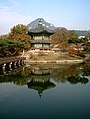
The Joseon Dynasty built "Five Grand Palaces" in Seoul:
- Changdeokgung (창덕궁; 昌德宮)
- Changgyeonggung (창경궁; (昌慶宮)
- Deoksugung (덕수궁; 德壽宮)
- Gyeongbokgung (경복궁; 景福宮)
- Gyeonghuigung (경희궁; 慶熙宮)
Museums
- National Museum of Korea(국립중앙박물관; 國立中央博物館)
- National Folk Museum(국립민속박물관; 國立民俗博物館)
- War Memorial(전쟁기념관; 戰爭紀念館)
Outside the metropolitan area:
- Namhansanseong(남한산성; 南漢山城)
- Bukhansanseong(북한산성; 北漢山城)
- Namsan Park(남산공원; 南山公園)
Temples and shrines
- Jongmyo(종묘; 宗廟)
- Dongmyo(동묘; 東廟)
- Munmyo(문묘; 文廟)
- Jogyesa(조계사; 曹溪寺)
- Hwagyesa(화계사; 華溪寺)
- Bongeunsa (봉은사; 奉恩寺)
Parks and outdoor attractions
Seoul's air pollution levels are now on par with those of Tokyo and significantly lower than those of Beijing.[4] Seoul's metropolitan area accommodates six major parks, including Seoul Forest, which opened in mid-2005. The Seoul National Capital Area also contains a green belt aimed to prevent the city from sprawling out over the neighboring Gyeonggi Province. These areas are frequently sought after by people resting on the weekend and during vacations.
In addition, Seoul is also home to an indoor amusement park, Lotte World. Other recreation centres include the former Olympic and World Cup stadiums and the City Hall's public lawn.
Sports
Seoul hosted the 1988 Olympic Games and Paralympic Games. It also served as one of the host cities of the 2002 FIFA World Cup. Seoul World Cup Stadium hosted the opening ceremony and first game of the tournament.
Taekwondo is Korea's national sport and Seoul is the location of the Kukkiwon, also known as the World Taekwondo Federation (WTF), the world headquarters of taekwondo.
The city is home to two baseball teams in the KBO: the Doosan Bears and the LG Twins & two basketball teams in the KBL: the Seoul Samsung Thunders and Seoul SK Knights.
There is one professional football club in Seoul, FC Seoul, which plays in the K-League. Two K3 League teams are based in the capital, Seoul United and Eungpyeong Chung-goo FC.
This section needs expansion. You can help by making an edit requestadding to it . |
Transportation
Seoul's transportation boom dates back to the era of the Korean Empire, when the first streetcar lines were laid and a railroad linking Seoul and Incheon was completed. Today, as a result of the diversification of Seoul's transportation network, it has become a great transportation hub for Asia.
Seoul hosts more than three million registered vehicles and widespread traffic congestion is common.
Airports
There are two airports that serve Seoul. Gimpo International Airport, formerly in Gimpo but annexed to Seoul in 1963, was the only airport for Seoul from its original construction during the Korean War. Multiple airports were built in and around Seoul immediately before, during, and after the war. The most famous was on Yeouido, which once served as the country’s gateway to the world.
Upon opening in March 2001, Incheon International Airport on Yeongjong island in Incheon changed the role of Gimpo Airport significantly. Incheon is now responsible for almost all international flights and some domestic flights, while Gimpo serves only domestic flights with the exception of flights to Haneda Airport in Tokyo and Hongqiao Airport in Shanghai. This has led to a significant drop in flights from Gimpo Airport.
Meanwhile, Incheon International Airport has become, along with Hong Kong and Singapore, a major transportation centre for East Asia. The 2005 AETRA passenger survey, jointly administered by the IATA and Airports Council International, voted it the best airport in the world.[5] It was named by Skytrax as the world's 5th best airport for 2006.[6]
Incheon and Gimpo are linked to Seoul by highways, and Gimpo is also linked by subway (line #5). The Incheon International Airport Railroad, a rail line connecting Incheon Airport to Gimpo Airport opened in March 2007, but the line to Seoul Station in central Seoul will take at least a year more to open. Shuttle buses transfer passengers between Incheon and Gimpo airports.
Bus
Seoul's bus system is operated by the Seoul Metropolitan Government, with four primary bus configurations available servicing most of the city.

Seoul has many big intercity/express bus terminals. These buses are connecting Seoul and cities all around Korea. Major bus terminals are
- Seoul Express Bus Terminal in Seocho-gu
- Central City in Seocho-gu
- Seoul Nambu Terminal, also in Seocho-gu
- Dongseoul Bus Terminal in Gwangjin-gu
- Sangbong Terminal in Jungnang-gu
Subway
Seoul has eight subway lines that interlink every district of the city with one another and with the surrounding area. The majority of the population now uses the public transportation system due to its convenience and low cost. With more than 8 million passengers a day, Seoul has one of the busiest subway systems in the world. In addition, in order to cope with all of these transportation modes, Seoul's metropolitan government employs several mathematicians to coordinate the subway, bus, and traffic schedules into one timetable. The 10 lines are run by Korail, Seoul Metro and SMRT.
Train

Seoul is connected to every major city in Korea by railroad. Seoul is also linked to most major Korean cities by the KTX bullet train which features a normal operation speed of more than 300 km/h, making commuting between cities extremely convenient for commuters and tourists. Major railroad stations include:
- Seoul Station, Jung-gu - Gyeongbu line (KTX/Saemaul/Mugunghwa-ho), Gyeongui line (Saemaul/Commuter)
- Yongsan Station, Yongsan-gu - Honam line (KTX/Saemaul/Mugunghwa), Jeolla/Janghang lines (Saemaul/Mugunghwa)
- Yeongdeungpo Station, Yeongdeungpo-gu - Gyeongbu/Honam/Janghang lines (Saemaul/Mugunghwa)
- Cheongnyangni Station, Dongdaemun-gu - Gyeongchun/Jungang/Yeongdong/Taebaek lines (Mugunghwa)
Sister cities
Seoul has many sister cities. The year each relationship was formed is shown in parentheses below.
|
|
Gallery
This section contains an unencyclopedic or excessive gallery of images. |
-
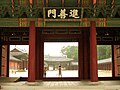
 Royal palace entrance
 -
-
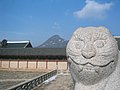 Haetae statue in Gyeongbokgung
 -
 Deoksugung, a place to see both the old and new of Seoul
 -
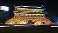 Namdaemun at night
 -
 Seoul Olympic Park, Songpa-gu
 -
-
Cheonggyecheon in Seoul
-
 63 Building in Yeouido, once the tallest building in Korea
 -
 The underside of N Seoul Tower
 -
 Northern area of Seoul
 -
Seoul at night
-
Avenue Sejong at night
-
 Namdaemun Market scene
 -
 Korea's famous 'flower-dance'
 -
 Jongno Street
 -
 Hyangwonjeong (in Gyeongbokgung)
 -
Seoul Olympic Stadium
-
 A train in AREX Incheon International Airport station heading for Gimpo International Airport.


See also
- List of Korea-related topics
- List of cities in South Korea
- Names of Asian cities in different languages
- Seoul National Capital Area
References
- ^ http://www.bbc.co.uk/weather/world/country_guides/results.shtml?tt=TT002800 BBC Weather - Country Guide
- ^ Park, Chung-a (2007-07-24). "Foreign Population in Seoul Stands at 175,000". Korea Times. Retrieved 2008-01-06.
- ^ World Bank reports, 2004
- ^ http://www.iges.or.jp/en/ue/activity/mega-city/article/htm/far41.htm - Environment Report
- ^ "Airport Service Excellence Awards for 2005". ACI. 2006-03-07. Retrieved 2006-08-25.
- ^ "Airport of the Year 2006". World Airport Awards. Skytrax. Retrieved 2007-02-25.
External links
Official sites
Tourism and living information
- Template:Wikitravel
- Go Seoul City: Comprehensive guide to the city
- Highlights of Seoul: by Korean National Tourism Organization
- AroundSeoul.com: Seoul Nightlife & Entertainment Guide
Maps and images
- Seoul Map Browser (from Seoul Metropolitan Government web site)
- Seoul Buildings Photos
- Photos of Seoul
- Seoul subway map (pdf in zip format)
Others
| Districts |
|  | ||||
|---|---|---|---|---|---|---|
| Business districts |
| |||||
| Districts |
| | ||||
|---|---|---|---|---|---|---|
| Business districts |
| |||||
| |
[c1] Cancelled due to World War I; [c2] Cancelled due to World War II; [c3] Postponed to 2021 due to the COVID-19 pandemic |
37°32′60″N 126°58′60″E / 37.55000°N 126.98333°E Coordinates: latitude seconds >= 60
Coordinates: longitude seconds >= 60
{{#coordinates:}}: invalid latitude