
Bluegrass region
38°00′N 84°30′W / 38.0°N 84.5°W


The Bluegrass Region is a region in the United States, mostly in northern Kentucky, containing a majority of the state's population. The region is centered on Template:USCity, and includes Template:USCity and Template:USCity, as it extends into southwestern Ohio and southeastern Indiana. The Inner Bluegrass Region (shown in light green on the accompanying map) includes the counties of Franklin, Scott, Harrison, Woodford, Fayette, Bourbon, and Jessamine.
The region gets its name from bluegrass, the common name for grass of the genus Poa, which is a favored lawn and pasture grass in the eastern United States from Tennessee northward.
The Bluegrass region is characterized by underlying fossiliferous limestone, dolostone, and shale of the Ordovician geological age. Hills are generally rolling, and the soil is highly fertile for growing pasture. Since antebellum years, the Bluegrass Region has been a center for breeding quality livestock, especially Thoroughbred race horses.
The area is becoming increasingly developed with residential and commercial properties, particularly around Lexington. Farms are losing ground to development and slowly disappearing. In 2006, The World Monuments Fund included the Bluegrass Region on its global list of 100 most endangered sites.
The Kentucky Bluegrass is bounded on the east by the Cumberland Plateau, with the Pottsville Escarpment forming the boundary. On the south and west, it borders the Pennyroyal Plateau, (also called the Pennyrile), with Muldraugh Hill, another escarpment, forming the boundary. Much of the region is drained by the Kentucky River and its tributaries. The river cuts a deep canyon called the Kentucky River Palisades through the region, preserving meanders that indicate that the river was once a mature low valley that was suddenly uplifted. Particularly near the Kentucky River, the region exhibits Karst topography, with sinkholes, caves, and disappearing streams that drain underground to the river.
Although Bluegrass music is popular throughout the region, the genre is actually indirectly named for the state rather than the region.[1]
The overall climate for this region of the United States is a humid subtropical climate. It is located within the Upland South region of the United States.
Gallery
-
 Bluegrass and rock fence of local limestone in central Kentucky.
 -
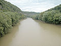 Kentucky River in the Bluegrass region.


References
- ^ Bill Monroe, considered the "Father of bluegrass music", named his band the Blue Grass Boys after his home state. He was from Rosine in western Kentucky. The music takes its name from that band, and hence from the state's nickname rather than the region.
External links
- Bluegrass Heritage Museum
- Local Directory for Frankfort, the State Capital
- Slayman, Andrew (Spring 2007). "A Race Against Time for Kentucky's Bluegrass Country". World Monuments Fund. Retrieved 2009-11-07.